This item has been sold, but you can get on the Waitlist to be notified if another example becomes available, or purchase a digital scan.
1675 Eberhard Werner Happel Map of the World (First Plate) w/currents
World-happel-1675$1,750.00

Title
Die Ebbe und Fluth auff einer flachen Landt-Karten fürgestelt.
1675 (undated) 8 x 11.25 in (20.32 x 28.575 cm) 1 : 90000000
1675 (undated) 8 x 11.25 in (20.32 x 28.575 cm) 1 : 90000000
Description
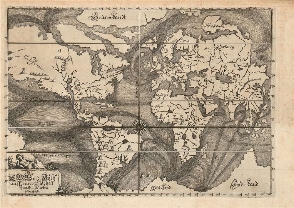
This is the rare, 1675 first plate of Eberhard Werner Happel's map of the world. This striking, unique engraving was 'identified as the earliest attempt to trace 'the more important ocean currents of the world' (The World Encompassed). Happel intended this map to illustrate not only the existence of ocean currents, but their causes: underground oceans, rivers, and volcanic activity, surely, were the cause of the baffling movements of the world's waters. To this end the map also illustrates no fewer than eighteen dramatically engraved volcanoes, at least twenty-four whirlpools, and four speculative subterranean connections between major bodies of water via eight titanic maelstroms.
Kirtcher quotes the Jesuit priest Peter Paez in describing such features,
1687 and 1708 examples of Happel's Mundus Mirabilis are well-represented in institutional collections. The separate map is catalogued only four institutional collections: Princeton, the British Library, the National Maritime Museum and the Bayerische Staatsbibliothek. Of these, those held by the BL and the NMM are the 1675 plate; the BSB has theirs dated 1687 but we have not examined it. Princeton's example is date 1675 but corresponds to plate 2.
Happel and Kircher
Happel's map was intended to illustrate his theory - derived from that of the German Jesuit polymath Athanasius Kircher - that the globe was honeycombed with subterranean rivers and seas which connected the oceans and rivers on the surface. While Kircher provided maps and diagrams illustrating his ideas in his 1665 Mundus Subterraneus, Happel here expands upon Kircher's theories significantly. The currents here are both more pronounced, more extensive, and more specific. Beyond those currents defined by Kircher, Happel expands the reach into the Pacific, as well as to the high Arctic and Antarctic zones. There are multiple recognizable currents, including the equatorial currents, the north Atlantic drift, and the gulf stream.Happel's Geographical Sources
The model of the world Happel employs would not have been considered state-of-the-art in 1675: it appears, unaccountably, to copy the basic outline of the 1622 Dirck Lons world map (perhaps via the intermediary of Jansson's 1626 and 1632 map.) The Lons would is odd map to copy, but the distinctive, peninsular form given to Nova Zembla and the unique, rectilinear truncation of northeastern Asia makes the connection clear. It may be that the selection of so forbiddingly obscure a source was a deliberate effort to create an illusion of originality.Kircher's Hydro-Volcanic System
Inspired by two weeks of earthquakes in Calabria in 1638, and the volcanic eruption of Vesuvius in 1637, Kircher postulated subterranean seas that created currents, earthquakes, and tides by entering and exiting through an extensive network of tunnels and abysses. This map, more than any other, fully illustrates these theories.Kirtcher quotes the Jesuit priest Peter Paez in describing such features,
On the 21st April in the year 1618, being there with the King and his army, I ascended the place and observed everything with great attention: I discovered first two round fountain each bout four palms in diameter, and saw with the greatest delight what neither Cyrus, the King of the Persians, or Cambysis, nor Alexander the Great, nor the famous Julius Caesar could ever discover. The two openings of these fountains have no issue in the plain on top of the mountain but flow from the root of it. The second fountain lies about a stone-cast west from the first: the inhabitants say that this whole mountain is full of water and add that the whole plain about the fountain is floating and unsteady, a certain mark that there is water concealed under it.Kircher's ideas may seem quaint to us today, but he was an excellent observer and a great reasoner. His work with currents in particular is revolutionary and among the first serious scientific studies of this phenomenon. He was also correct in surmising the superheated nature of the Earth's core. While his network of underground lakes and rivers connecting to giant reservoirs under mountain rangers was incorrect, his theory did correctly recognize that Earthquakes were caused by the movement of great plates of Earth. And, while his assessment regarding the source of the ocean currents was incorrect, his identification of current patters was often accurate.
Publication History and Census
This map was engraved for inclusion in Happel's E. G. Happelii grössester Denkwürdigkeiten der Welt oder so genandte Relationes Curiosae. We know of only one state of this map (as pictured in Shirley), and the book is catalogued in OCLC in six examples. Shirley states 'The same map later appeared in Happel's Mundus Mirabilis of 1687 and again in 1708.' This is not correct, and has led to much confusion in cataloguing. The very similar map appearing in this later work is re-engraved to a new plate. The second plate is distinguishable by numerous typographical changes and differences in hachure, but is most easily identified by the presence of an engraved page number in the upper right, lacking in the 1675 first plate.1687 and 1708 examples of Happel's Mundus Mirabilis are well-represented in institutional collections. The separate map is catalogued only four institutional collections: Princeton, the British Library, the National Maritime Museum and the Bayerische Staatsbibliothek. Of these, those held by the BL and the NMM are the 1675 plate; the BSB has theirs dated 1687 but we have not examined it. Princeton's example is date 1675 but corresponds to plate 2.
CartographerS
Eberhard Werner Happel (August 12, 1647 - May 15, 1690 ) was a German author, novelist, journalist and polymath. Though little is known of his education and apprenticeship, he was a prolific author whose works shared freely the qualities of both fiction and nonfiction. He was adept at the inclusion and elucidation of contemporary knowledge in his many works, thus providing his readers with novel scientific and political ideas in the context of his novels. More by this mapmaker...
Athanasius Kircher (c. 1601 - 1680) was a 17th century German Jesuit scholar and one of the most respected and remarkable men of his time. A master of languages, mathematics, science, geography, physics and oriental studies, many consider Kircher to be 'the last true Renaissance man.' Kircher attained almost global fame in his lifetime for his numerous scholarly publications. Indeed, Kircher was the first documented scholar able to fully support himself on his own work, which, in his case, included some forty volumes on diverse fields. As a Catholic in Germany, Kircher was frequently at odds with the rising powers of Protestantism. Consequently, in 1628 he joined the priesthood and after extensive world travels eventually settled in Rome. There he was employed as a Professor of Mathematics and Oriental Languages at the Collegio Romano. Inspired by the eruption of Vesuvius in 1637 and the two weeks of earthquakes that shook Calabria in 1638, Kircher turned his considerable intellect to the natural world. Kircher's research into Geography and Oceanography culminated in the postulation that tides and currents were caused by water moving to and from a great subterranean ocean. Kircher published his geographic work in the important 1664 Mundus Subterraneus, which in addition to several world and oceanic charts, included a fascinating map of Atlantis. Kircher is nonetheless, not unimpeachable. One anecdote tells how a rival scholar presented Kircher with a manufactured gibberish manuscript he claimed to be an recently discovered ancient Egyptian text in need of translation. Kircher produced the translation instantly. In addition to his significance as a scholar, Kircher is best known for his invention of the Magic Lantern, precursor to modern cinema. He also founded the Museum Kircherianum in Rome. Learn More...
Condition
Very good. Left margin close but complete; few minor marginal mends. Else excellent with a sharp strike.
References
OCLC 558062289. Shirley, Rodney W., The Mapping of the World: Early Printed World Maps 1472-1700, 468. Baltimore Museum of Art, The World Encompassed: an Exhibition of the History of Maps Held at the Baltimore Museum of Art, Oct. 7 to Nov. 23, 1952, 198.