
This item below is out of stock, but another example (left) is available. To view the available item, click "Details."
Details
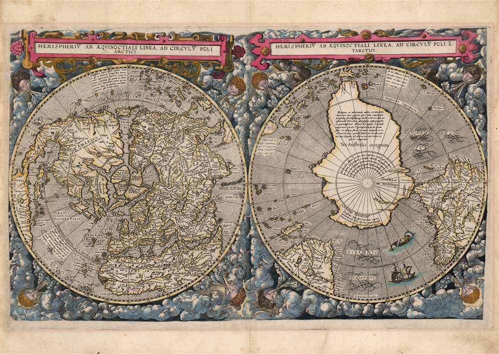
1593 Cornelis De Jode Double Hemisphere Polar Projection World
$62,500.00
1593 Cornelis De Jode Double Hemisphere Polar Projection World
World-jode-1593$45,000.00

Title
Hemispheriū Ab Aequinoctli Linea, Ad Circulū Poli Arctici / Hemispheriū Ad Circulū Poli Ātarctici.
1593 (undated) 12.5 x 20.25 in (31.75 x 51.435 cm) 133000000
1593 (undated) 12.5 x 20.25 in (31.75 x 51.435 cm) 133000000
Description
This is a beautiful example of Cornelis De Jode's 1593 double-polar projection map of the world. It is among the most striking early world maps, and among the earliest to introduce the double hemispheric polar projection. Moreover, as a competitor to Ortelius' cartography, it is the sole obtainable map to preserve the innovative Guillaume Postel / Antwerp Unicum cartography. The map is moreover exceedingly rare, having been published in only a single edition.
De Jode's map includes several recognizable place names in the southeast: including Florida and Cape Canaveral. De Jode's spelling of this place, Cagnaveral, as well as its delineation, are drawn from the Ortelius' 1564 cordiform.
The southern hemisphere is dominated by a massive Terra Australis Incognita, extending northwards from the pole to absorb both Tierra del Fuego and New Guinea. Whereas Postel divided his southern hemisphere into two separate insets subordinate to his northern hemisphere, De Jode presents the hemispheres equally. The latter approach allows for a focused presentation of the speculative southern continent. A note on the coast nearest Africa suggests that the Portuguese had, from a promontory on the Cape of Good Hope, reported seeing a land mass to the south, but that nobody had actually found it. In addition to the place name 'Ter. Australis incognita,' De Jode employs the term 'Chasdia'. This too is drawn from Postel, appearing both in his book, Cosmographicae, and on his map.
The Sources
To differentiate his map from his competitor Ortelius' Mercator-derived maps, De Jode drew on an array of sources: predominantly the 1581 world map of Guillaume Postel, and an anonymous, c. 1587 globe known as the Antwerp Unicum. To these, De Jode applied his own geographical innovations to produce a remarkable fresh work. Postel's work and the Unicum each survive in only a single confirmed example, making this De Jode map the only acquirable work to preserve their content.Postel
Guillaume Postel (1510 - 1581) was a French scholar and mystic whose wide-ranging output included a world map (Polo Aptata Nova Charta Universi) whose polar projection was the primary influence on the present composition. A woodcut on six sheets, this map was executed by Jean de Gourmont in 1581 and survives in a sole example at the Service Historique de la Marine. Postel's geography drew heavily on the 1564 Gerard de Jode / Abraham Ortelius cordiform world map. Postel's theories on the hypothetical southern continent and his interpretations of the Arctic thus figured prominently in this, the younger De Jode's 1593 map.The Antwerp Unicum
The Antwerp Unicum, so-called because of its city of composition, the absence of other surviving examples, and its anonymous maker. The Unicum consists of a full set of terrestrial globe gores, which Shirley dates c. 1587 and scholar Marcel Destombes argues were engraved in Antwerp on behalf of the De Jodes. The Unicum is assiduous in citing its sources, which include Ortelius, Thevet, and Postel.A Closer Look
Double-hemisphere projections were atypical in the 16th century, and this map, employing dual polar projections, is both unique and among the earliest to adopt this convention. The hemispheres are framed with turbulent clouds, in which eight wind-heads puff furiously. The map's title is presented at top in a pair of elegant, strapwork cartouches - the cartouche for the southern hemisphere is supported by faun-like gargoyles. Both hemispheres' oceans are neatly stippled, and the calligraphic engraving is of highest quality with text blocks are sharp and legible. The southern Atlantic sports both a sea monster and a pair of sailing ships.The Arctic Islands
In composing this map, De Jode likely had access to both Postel's map and the Antwerp Unicum, as it contains elements unique to each. Scrutiny of the map's presentation of Mercator's four Arctic landmasses will show, for example, that the Arctic landmass directly north of Scandinavia is conflated with the island of Nova Zembla. This appears on both precursor maps. But on the De Jode, the island falling to the east of this 'Nova Zembla' is connected to the Siberian mainland. (Despite being referred to in text as 'the best island in the whole north.') The Postel map here illustrated a conglomeration of ice floes and described an ice bridge between the mainland and the island. The Unicum shows a misinterpretation of these ice floes as an isthmus, and it is this depiction - not that of the Postel - that De Jode follows. Curiously, an ice bridge did occasionally form in this region, linking the Siberian mainland with the Lyakhovsky Islands (New Siberian Archipelago) - known for its rich deposits of fossilized mammoth ivory. Although occasionally visited by trappers and fortune hunters during winter freezes, these islands were not documented until the late 18th century.American Eastern Seaboard
On the other hand, the De Jode North American east coast includes elements drawn from the Postel that are not shared with the Antwerp Unicum, most notably the deep bay along the eastern seaboard. Postel drew this feature from the 1564 Ortelius wall map, although both maps offer different toponomy: the peninsula here is marked 'C. de S. Helena,' and at the extremity of the bay is the legendary city-of-gold of Norumbega. A rough, early Saint Lawrence can be discerned, derived ultimately from the reports of Cartier, and is most recognizable for the naming of Hochelaga (Montreal). A sketchy river system leading inland from Hochelaga, suggests at what may be an early, embryonic attempt at the Great Lakes.De Jode's map includes several recognizable place names in the southeast: including Florida and Cape Canaveral. De Jode's spelling of this place, Cagnaveral, as well as its delineation, are drawn from the Ortelius' 1564 cordiform.
Japan and the West Coast
The positioning of Japan close to the American west coast, the multitude of Spice Islands, and the delineation of the Caribbean are drawn from Postel. The map includes several annotations pertinent to Japan. One describes its antipodean position in relation to Flanders - 'when it is midday here, in Japan it is the middle of the night.' A further Latin text in the South Atlantic describes the 1582-1584 Tenshō Embassy - a Japanese scholarly and diplomatic visit to the Vatican of Pope Gregory XIII (he was the first Pope to receive such). These notes are absent on both the Postel and the Antwerp Unicum. Their inclusion here emphasized the contemporary relevance of De Jode's map. Japan does not appear in a dedicated atlas map until 1595, so even the tentative detail here represents a significant advance.The Southern Hemisphere
The Southern Hemisphere presented here is somewhat unique to De Jode. South America's detail largely conforms with Gerard De Jode's 1578 Americae Peruvi Aque Ita ut Postremum Detecta Traditur Recens Delineatio. It additionally references Postel's terminology Residuum Atlantidis meridiana Peru Pars (Residuum Peru Americae).The southern hemisphere is dominated by a massive Terra Australis Incognita, extending northwards from the pole to absorb both Tierra del Fuego and New Guinea. Whereas Postel divided his southern hemisphere into two separate insets subordinate to his northern hemisphere, De Jode presents the hemispheres equally. The latter approach allows for a focused presentation of the speculative southern continent. A note on the coast nearest Africa suggests that the Portuguese had, from a promontory on the Cape of Good Hope, reported seeing a land mass to the south, but that nobody had actually found it. In addition to the place name 'Ter. Australis incognita,' De Jode employs the term 'Chasdia'. This too is drawn from Postel, appearing both in his book, Cosmographicae, and on his map.
A War of Maps
This map appeared only in the second and final 1593 edition of Gerard and Cornelis De Jode’s Speculum Orbis Terrarum. It is one of the maps added by Cornelis in to make the Speculum more competitive with Ortelius' Theatrum Orbis Terrarum, as well as current with late 16th century cartographical advances. Nonetheless, the Speculum was unable to break Ortelius' lock on the market and was printed in only one edition. After Cornelis’ death in 1600, the plates were purchased by Jan Baptist Vrients, then publishing Ortelius’ atlas, and suppressed (likely destroyed). There were no later printings of De Jode’s maps.An Attractively Colored Example
Examples of this and De Jode's other maps are known both with and without color. We do not believe the present coloring to be recent, and it may be old. The palette conforms to another example held at the National Library of Australia, particularly as regards the reds, the coloring of clouds, and ocean highlighting below sea monsters.Publication History and Census
This map was engraved after the 1587 prototype, with a multitude of improvements in topology and legibility. It was prepared for Cornelis De Jode's 1593 Speculum Orbis Terrarum. It appears in a single state with no further editions. We are aware of one separate example of the map in the National Library of Australia. Perhaps twenty-two examples of the 1593 Speculum are listed in OCLC.CartographerS
Cornelis de Jode (1568 – October 17, 1600) was an Antwerp cartographer, engraver and publisher, He was the son and heir of Gerard de Jode, also a cartographer and publisher. Cornelis studied science at Academy of Douai, but it can be understood that his main education in the trade was at the hands of his father. On his father's death in 1591, Cornelis de Jode took over the work on his father's atlas, Speculum Orbis Terrarum. This had enjoyed publication in a single edition of 1578, overshadowed by the competition posed by Abraham Ortelius' (1527 - 1598) Theatrum Orbis Terrrum. Cornelis published a second edition, to which he added many updated maps to bring the work up to date with its competition. Despite the improvements brought to the atlas, both aesthetic and geographic, De Jode was unable to break Ortelius' grip on the market and there were no further editions of the atlas. After his death, the engraving plates were sold to Ortelius' executor Johannes Baptista Vrients (1552 - 1612), who was continuing to publish the Theatrum. Vrients would utilize several decorative plates from the Speculum, but the complete work and its maps were not published again - likely they were destroyed by Vrients to keep them from competing with his editions of the i>Theatrum. More by this mapmaker...
Gerard De Jode (1516/17 - February 5, 1591) was a Dutch publisher, engraver and cartographer active in Antwerp in the mid-to-late 16th century. De Jode was born in Nijmegen. Following a period as an apprentice and journeyman, (about which nothing comes down to us), he was admitted as a free master to Antwerp's artists' Guild of Saint Luke in 1547. He received the right to publish in that city in 1551. Henceforth he worked as a publisher and printseller in that city - although records also refer to him as a bookseller, art seller, map painter, engraver, and plate printer. He became one of Antwerp's most successful and prolific printers: he built up a large and varied stock of more than 1,200 prints and maps, and in addition to his own children maintained a shop and was taking on apprentices as early as 1549. De Jode's shop was home to many of Antwerp's best engravers, including the famous Van Doetecum brothers.
His publication in 1579 of the Thesaurus sacrarumhistoriarum veteris testamenti set the standard for over a century of Biblical illustration. His cartographic work began with the printing of other mapmakers' work (for example Gastaldi's map of the world in 1555, Jacob van Deventer's map of Brabant in 1558, and Ortelius' eight sheet map of the world in 1564.) He is best known for his 1578 atlas Speculum Orbis Terrarum. Despite the excellence of this work, it performed poorly due to the overwhelming competition posed by Abraham Ortelius' Theatrum Orbis Terrarum, which had already been eight years in publication. Between the Theatrum's popularity (and Ortelius' superior political connections, employed successfully in a vigorous defense of his license and monopoly on the work) De Jode's atlas was never a strong seller. Gerard printed only one edition of the work, compared to something on the order of 40 for the Ortelius atlas. Gerard de Jode planned an enlarged edition, but died before it could be finished. His son Cornelis de Jode completed the labor, publishing the Speculum Orbis Terrae in 1593. This edition, too, of the Speculum failed to compete with Ortelius' powerhouse. On top of that, much of the De Jodes' stock was actively purchased and destroyed by Ortelius and his executors in order to remove it from the market. Thus, oneresult of De Jode's ill-starred competition with Ortelius is that while most of Ortelius' maps are relatively ubiquitous on the market, all of De Jode's maps are rare, and sought after by the discerning collector. Learn More...
Guillaume Postel (March 25, 1510 – September 6, 1581) was a French linguist, astronomer, Christian Kabbalist, diplomat, polyglot, professor, religious universalist, and writer. He was born in Normandy, educated in Paris, and during his time there met Ignatius of Loyola and many of the founders of the Society of Jesus, retaining a lifelong affiliation with them (although he did not take vows with the order.) He was an adept linguist, focusing primarily on Semitic languages as well as Greek and Latin; this facility brought him to the attention of the French court, who would tap him for diplomatic duties. He attended the 1536 embassy of Jean de La Forêt to the Ottoman sultan Suleiman the Magnificent as a translator; Postel also acquired Ottoman manuscripts for the royal library, which remain in the Bibliothèque Nationale. Postel's works range from anaylses of Hebrew characters on Roman era coins to critiques of Protestantism, descriptions of Turkish society, studies of universal traits in world religions, and arguments for the unification of all Christian sects. His interests also impinged on cartography, partly stemming from his collection of manuscripts from the Holy Land and Syria. He published a geographical work in 1557 De Universitate Liber and appears to have drawn a polar projection map, although this was not published. He expanded on his work in Cosmographicae Disciplinae Compendium. Neither of these works contained any but the smallest and most diagrammatic maps, but in Cosmographicae, Postel clearly set out his geographical ideas, including the naming of an Australian continent - Chasdia - distinctly separate from both Asia and Africa. Cosmographicae included an index of place names which would inform his 1581 world map, Polo aptata Nova Charta Universi. This map is unacquirable - it survives in only a single confirmed example - would influence several sixteenth century mapmakers, none so apparently as Cornelis de Jode in his 1593 polar projection world map.
Postel would also travel extensively in Central Europe and Italy, all the while building his manuscript collection, and translating many works. His ideas on universalism would combine with a conviction that he was experiencing prophetic visions, and that he was destined to become a unifier of all the world's religions. His publication of these ideas would put him before the Inquisition. Allies amongst his prosecutors were able to find him guilty of insanity, winning him imprisonment in preference of the execution a finding of heresy would result in. He would eventually be freed, but the 1566 exorcisms of Nicole Aubrey in Laon affected him to such a degree that he felt compelled to publish an account of it. In it, he repeated his insistence upon the interrelatedness of all parts of the universe and his own role in the unification of the world's faiths. As a result, he was returned to house arrest and spent the rest of his life confined to a monastery. Learn More...
Source
De Jode, Cornelis, Speculum Orbis Terrarum, (Antwerp: Arnold Coninx) 1593.
Gerard De Jode (1516/17 - 1591) first issued his spectacular atlas, the Speculum Orbis Terrae, in Antwerp in 1578. The atlas was intended to compete with Abraham Ortelius' Theatrum Orbis Terrarum, and as such, was a lavish production, beautifully engraved and compiled from the best cartography of the period. De Jode drew from such illustrious sources as G. Gastaldi, Pirro Ligorio, Alvaro Seco, Lieven Algoet, Heinrich Zell, Wolfgang Lazius, Augustin Hirsvogel, Sebastian Rotenhan, Aegidius Tschudi, Bartholomaeus Scultetus, and Caspar Vopel. Like due to his lack of political connects and general business acumen, De Jode's Speculum never attained the widespread popularity of Ortelius' Theatrum. When Gerard died in 1591, the firm was taken over by his son, Cornelis de Jode (1568 - 1600) and, his wife, Paschina. C. De Jode partnered with Arnold Coninx to publish a new edition of the Speculum Orbis Terrae in 1593. Cornelius died young at 32, and the De Jode stock was sold to Johannes Baptista Vrients (1552 - 1612). Vrients had earlier acquired Ortelius's map plates and was actively republishing them. He did not similarly republish the Speculum Orbis Terrae; rather, his purchase of the De Jode plates was intended to keep them off the market. Most were destroyed at his hands, resulting in them never being reprinted and being exceptionally scarce today.
Condition
Very good. Gently toned, else an excellent example with fine hand color, possibly old.
References
OCLC 793033413. Shirley, Rodney W., The Mapping of the World: Early Printed World Maps 1472-1700, 184 (also pictured on cover). Destombes, M., 'An Antwerp 'Unicum': An Unpublished Terrestrial Globe of the 16th Century in the Bibliothèque Nationale, Paris.' Imago Mundi 24 (1970): 85–84.