This item has been sold, but you can get on the Waitlist to be notified if another example becomes available, or purchase a digital scan.
1862 Lloyd Map of the World of Mercator's Projection
World-lloyd-1862$75.00

Title
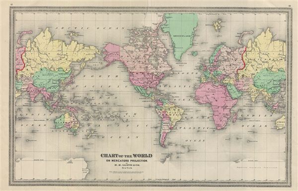
Chart of the World on Mercators Projection.
1862 (undated) 14 x 22 in (35.56 x 55.88 cm)
1862 (undated) 14 x 22 in (35.56 x 55.88 cm)
Description
This is a fine example of the 1862 H. H. Lloyd map or chart of the world on Mercator's Projection. The map is centered on the American continent and a portion of Asia is duplicated to show its connection with the United States. The Antarctic continent is shown only sketchily as 'Supposed Southern Continent,' representing the relatively primitive state of Antarctic exploration during this time. Identifies numerous cities, countries, rivers, cities, oceans, deserts, and various other topographical features. Map is hand colored to define national and regional boundaries. Prepared by H. H. Llloyd and Co., New York as plate nos. 12 and 13 for the 1862 edition of the Atlas of the United States.
Cartographer
H.H. Lloyd & Company (fl. 1860 - 1890) were 19th century American map and atlas publishers based in New York City. They should not be confused with the competing New York firm with of a similar name, J. T. Lloyd, with whom H. H. Lloyd had a ongoing conflict. The firm was founded by H. H. Lloyd and Benjamin S. Demarest in 1860. The H. H. Lloyd firm published numerous atlases, wall maps, and gazetteers before, during and after the American Civil War. These include some of the best maps of the period, many of which were used as battle plans by various Civil War generals on both sides of the conflict. From various offices around the city, the H.H. Lloyd firm worked with other prominent firms of the period including H. S. Stebbins, Warner and Beers to produce numerous state and county atlases. Around 1880 Demarest took full control of the firm, possibly suggesting that Lloyd either died or retired. Though H. H. Lloyd and Company continued to produce maps well in to the 1880s, the firm lost much of its momentum and eventually, by 1890, closed its doors. H. H. Lloyd is sometimes confused with J. T. Lloyd, another map publisher of the period who produced a small number of United States and regional maps sympathetic to the Confederacy. Both H. H. Lloyd and B. Demarest were Union supporters, Demarest having served as a Major in the Union Army. More by this mapmaker...
Source
Lloyd, H. H., Atlas of the United States, 1862.
Condition
Very good. Original centerfold visible. Minor wear along centerfold.