1696 Pierre Mortier Polar Projection Map on Two Hemispheres
World-mortier-1696$4,950.00

Title
Les Deux Poles Arctique ou Septentrional, et Antarctique ou Meridional, ou Description des Terres Arctiques et Antarctiques ; et des Pays circomvoisins jusques aux 45. Degres de Latitude.
1696 (undated) 17.25 x 20.75 in (43.815 x 52.705 cm)
1696 (undated) 17.25 x 20.75 in (43.815 x 52.705 cm)
Description
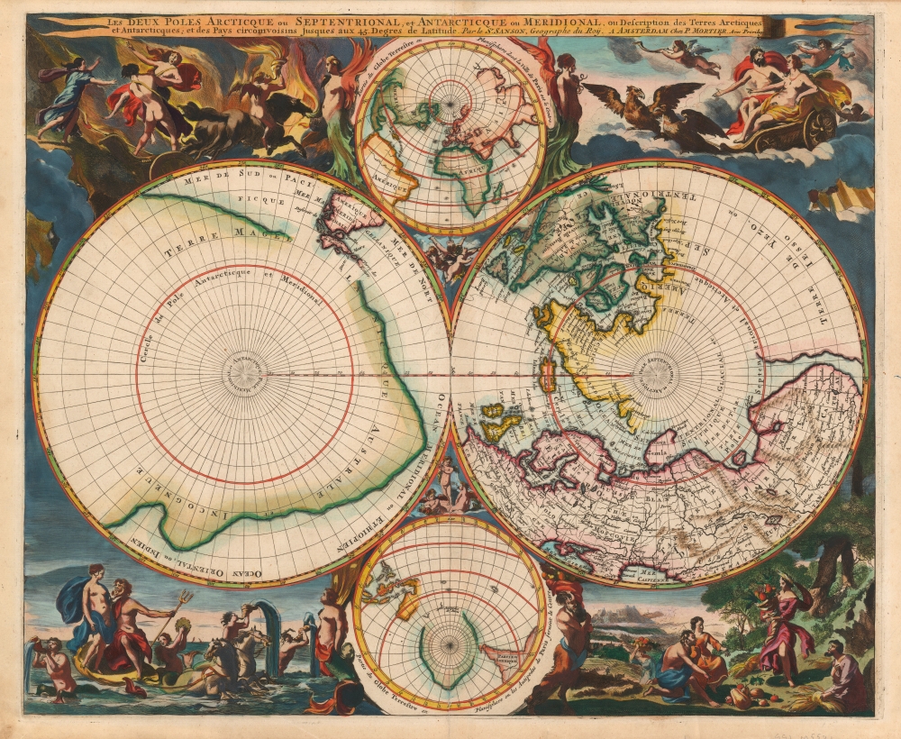
This is a beautiful example of Peter Mortier's 1696 double-hemisphere map of the northern and southern hemispheres. The primary hemispheres focus on the northern and southern thirds of the world. The secondary hemispheres show the entire world, centered respectively on Paris and its antipodes.
The northern hemisphere shows Europe north of central France and the Black Sea, Asia north of the Caspian Sea and Turkestan, and Spitzbergen and Nova Zemla are shown as partial coastlines. North America shows the Great Lakes in their unfinished, 'Sanson-type' form. The northern part of North America is shown, including the Saint Lawrence River, Newfoundland, and the Canadian Maritimes. Hudson's Bay, Button's Bay, Baffin's Bay, and the Davis Strait are all shown, with numerous openings in the coastline suggesting the possibility of a Northwest Passage. Greenland is contiguous with North America, nearly connecting with Spitzbergen. Additionally, the North American landmass reaches westward to include the speculative Terre de Yezo, ou Iesso, which contemporaneous cartographers presented as beginning as the island of Hokkaido.
The two ancillary hemispheres at top and bottom, focusing on Paris and its antipodes, did not appear on the 1657 Sanson. The 1658 Visscher (from which the decorative engraving was sourced) did have ancillary hemispheres, but their contents differed. (The Visscher map's smaller hemispheres were polar projections extending to the 50th degree of latitude.) We do not see a precise precursor to these hemispheres, although Mortier also included them in his Mappe-Monde Dressé sur les Observations de Mrs. De L'Academie Royale des Sciences, published the same year as the present work. While the geography of these projections does not match up precisely with that of the primary hemispheres - for example, they lack the massive Terre de Yezo - they do provide a global context for the main maps that might be lacking given the absence of anything between the 45th parallels. The ancillary southern hemisphere also includes a rendition of Tasman's coastlines for Australia, Tasmania, and New Zealand - albeit oddly close to the imaginary Magellanica.
The top ancillary hemisphere is flanked by angelic figures, while the bottom is flanked by a mermaid (facing the water scene) and a satyr facing the Earth vignette. The cruxes of the four hemispheres are each peopled with a trio of putti.
The Geography
The geographical content of the primary hemispheres is drawn from the 1657 map of Nicolas Sanson (whose title is shared by the present work.) These do not constitute a world map per se. The polar projections end at 45º south and north, respectively. The southern polar projection on the right is dominated by a massive southern continent, marked Terre Magellanique Australe et Incogneue (the southern and unknown land of Magellanica.)The northern hemisphere shows Europe north of central France and the Black Sea, Asia north of the Caspian Sea and Turkestan, and Spitzbergen and Nova Zemla are shown as partial coastlines. North America shows the Great Lakes in their unfinished, 'Sanson-type' form. The northern part of North America is shown, including the Saint Lawrence River, Newfoundland, and the Canadian Maritimes. Hudson's Bay, Button's Bay, Baffin's Bay, and the Davis Strait are all shown, with numerous openings in the coastline suggesting the possibility of a Northwest Passage. Greenland is contiguous with North America, nearly connecting with Spitzbergen. Additionally, the North American landmass reaches westward to include the speculative Terre de Yezo, ou Iesso, which contemporaneous cartographers presented as beginning as the island of Hokkaido.
The two ancillary hemispheres at top and bottom, focusing on Paris and its antipodes, did not appear on the 1657 Sanson. The 1658 Visscher (from which the decorative engraving was sourced) did have ancillary hemispheres, but their contents differed. (The Visscher map's smaller hemispheres were polar projections extending to the 50th degree of latitude.) We do not see a precise precursor to these hemispheres, although Mortier also included them in his Mappe-Monde Dressé sur les Observations de Mrs. De L'Academie Royale des Sciences, published the same year as the present work. While the geography of these projections does not match up precisely with that of the primary hemispheres - for example, they lack the massive Terre de Yezo - they do provide a global context for the main maps that might be lacking given the absence of anything between the 45th parallels. The ancillary southern hemisphere also includes a rendition of Tasman's coastlines for Australia, Tasmania, and New Zealand - albeit oddly close to the imaginary Magellanica.
The Allegorical Decoration
The decorative elements - up to and including the framing of the secondary hemispheres and the cartouche banner - are copied from Nicolas Visscher's 1658 Orbis Terrarum Nova et Accuratissima Tabula. Visscher's artist - the Dutch painter Nicolaes Berchem - created nuanced, layered allegorical scenes representing each of the four elements. The scene for 'Air' shows Zeus and Hera in a chariot pulled by eagles, with putti flying in attendance. For 'Earth', in a woodland scene, Demeter gifts a hungry mankind the fruits of the Earth in an overflowing cornucopia. The scene representing 'Fire' takes place in the underworld, showing the abduction of Persephone by Hades. In the aquatic scene, Poseidon woos Aphrodite in a hippocampus-drawn chariot, with mer-putti bugling wetly from conches and playing tambourines.The top ancillary hemisphere is flanked by angelic figures, while the bottom is flanked by a mermaid (facing the water scene) and a satyr facing the Earth vignette. The cruxes of the four hemispheres are each peopled with a trio of putti.
Publication History and Census
The map was engraved in 1696 for inclusion in Mortier's Atlas Nouveau. A further state, bearing the Covens and Mortier imprint, was printed in and around 1730 (Kershaw #146 dates this 1761 and names it a third state, although he does not mention the present 1696 Pierre Mortier state.) The present first state is rare, and we see only a single example cataloged in OCLC appearing in the Bayerische Staatsbibliothek.CartographerS
Pierre Mortier (January 26, 1661 - February 18, 1711) or Pieter Mortier was a cartographer, engraver, and print seller active in Amsterdam during the later 17th and early 18th centuries. Mortier, then known as Pieter, was born in Leiden. He relocated to Paris from 1681 to 1685, adopting the French name Pierre, which he retained throughout his career. While in France, he developed deep French connections by bringing sophisticated Dutch printing technology and experience to nascent French map publishers such as Guillaume De L'Isle (1675 - 1726), Alexis-Hubert Jaillot (c. 1632 - 1712), and Nicholas de Fer (1646 - 1720). Consequently, much of Mortier's business was built upon issuing embellished high quality editions of contemporary French maps - generally with the permissions of their original authors. In the greater context of global cartography, this was a significant advantage as most Dutch map publishes had, at this point, fallen into the miasma of reprinting their own outdated works. By contrast, the cartographers of France were producing the most accurate and up to date charts anywhere. Mortier's cartographic work culminated in the magnificent nautical atlas, Le Neptune Francois. He was awarded the Privilege, an early form of copyright, in 1690. Upon Pierre's death in 1711 this business was inherited by his widow. In 1721, his son Cornelius Mortier took over the day to day operation of the firm. Cornelius partnered with his brother-in-law Jean Covens to form one of history's great cartographic partnerships - Covens and Mortier - which continued to publish maps and atlases until about 1866. More by this mapmaker...
Nicolas Sanson (December 20, 1600 - July 7, 1667) and his descendants were the most influential French cartographers of the 17th century and laid the groundwork for the Golden Age of French Cartography. Sanson was born in Picardy, but his family was of Scottish Descent. He studied with the Jesuit Fathers at Amiens. Sanson started his career as a historian where, it is said, he turned to cartography as a way to illustrate his historical studies. In the course of his research some of his fine maps came to the attention of King Louis XIII who, admiring the quality of his work, appointed Sanson Geographe Ordinaire du Roi. Sanson's duties in this coveted position included advising the king on matters of geography and compiling the royal cartographic archive. In 1644, he partnered with Pierre Mariette, an established print dealer and engraver, whose business savvy and ready capital enabled Sanson to publish an enormous quantity of maps. Sanson's corpus of some three hundred maps initiated the golden age of French mapmaking and he is considered the 'Father of French Cartography.' His work is distinguished as being the first of the 'Positivist Cartographers,' a primarily French school of cartography that valued scientific observation over historical cartographic conventions. The practice result of the is less embellishment of geographical imagery, as was common in the Dutch Golden Age maps of the 16th century, in favor of conventionalized cartographic representational modes. Sanson is most admired for his construction of the magnificent atlas Cartes Generales de Toutes les Parties du Monde. Sanson's maps of North America, Amerique Septentrionale (1650), Le Nouveau Mexique et La Floride (1656), and La Canada ou Nouvelle France (1656) are exceptionally notable for their important contributions to the cartographic perceptions of the New World. Both maps utilize the discoveries of important French missionaries and are among the first published maps to show the Great Lakes in recognizable form. Sanson was also an active proponent of the insular California theory, wherein it was speculated that California was an island rather than a peninsula. After his death, Sanson's maps were frequently republished, without updates, by his sons, Guillaume (1633 - 1703) and Adrien Sanson (1639 - 1718). Even so, Sanson's true cartographic legacy as a 'positivist geographer' was carried on by others, including Alexis-Hubert Jaillot, Guillaume De L'Isle, Gilles Robert de Vaugondy, and Pierre Duval. Learn More...
Claes Jansz Visscher (1587 - 1652) established the Visscher family publishing firm, which were prominent Dutch map publishers for nearly a century. The Visscher cartographic story beings with Claes Jansz Visscher who established the firm in Amsterdam near the offices of Pieter van den Keer and Jadocus Hondius. Many hypothesize that Visscher may have been one of Hondius's pupils and, under examination, this seems logical. The first Visscher maps appear around 1620 and include numerous individual maps as well as an atlas compiled of maps by various cartographers including Visscher himself. Upon the death of Claes, the firm fell into the hands of his son Nicholas Visscher I (1618 - 1679), who in 1677 received a privilege to publish from the States of Holland and West Friesland. The firm would in turn be passed on to his son, Nicholas Visscher II (1649 - 1702). Visscher II applied for his own privilege, receiving it in 1682. Most of the maps bearing the Visscher imprint were produced by these two men. Many Visscher maps also bear the imprint Piscator (a Latinized version of Visscher) and often feature the image of an elderly fisherman - an allusion to the family name. Upon the death of Nicholas Visscher II, the business was carried on by the widowed Elizabeth Verseyl Visscher (16?? - 1726). After her death, the firm and all of its plates was liquidated to Peter Schenk. Learn More...
Source
Mortier, P., Atlas Nouveau, (Amsterdam) 1696.
Condition
Very good. Reinforced at bottom centerfold and top margin. Remains of old hinge tape on verso. Fine original color refreshed, heightened with gold.
References
OCLC 159851808. cf Shirley, Rodney W., The Mapping of the World: Early Printed World Maps 1472-1700, 406, 408. cf. Tooley, Mapping of Australia, p. 189. cf. Kershaw, Kenneth A., Early Printed Maps of Canada #146; Phillips, P. L. A List of Geographical Atlases in the Library of Congress #3448-14.