This item has been sold, but you can get on the Waitlist to be notified if another example becomes available, or purchase a digital scan.
1550 Münster Map of the World
World-munster-1550$1,875.00

Title
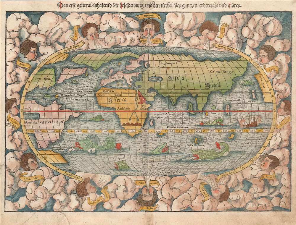
Das erst general, inhaltend die beschreibung und den circkel des gantzen erdtreichs und môres.
1550 (undated) 10.5 x 14.75 in (26.67 x 37.465 cm) 1 : 120000000
1550 (undated) 10.5 x 14.75 in (26.67 x 37.465 cm) 1 : 120000000
Description
This is the first, 1550 German edition of the second block of Sebastian Münster's map of the world, one of the most distinctive to be produced during the Age of Discovery. In the mid-sixteenth century, it was the best summation of the rapidly-expanding known world available to the literate European. The map was included in Münster's magnum opus, Cosmographia Universalis, for over forty years was the primary source for anyone who wished knowledge of the world. Consequently, this map would have had a disproportionate impact, providing the first presentation of a circumnavigable world for nearly half a century. It would not be challenged until the 1570 publication of Ortelius' Theatrum Orbis Terrarum. As important as its geographical revelations were, the map is also rich in the imagery of its era: it is bordered with billowing clouds, with wind-heads marking the cardinal directions, puffing their breezes over the waters. The oceans are prowled by eight sea monsters; a sailing ship is shown crossing the Pacific and proudly firing its cannons.
Likewise, it is one of the earliest acquirable world maps to show the continent of Africa in recognizable form. Madagascar appears in roughly the correct location. Oddly, Zanzibar appears as an island much farther out from land. Africa's interior nonetheless retains the Ptolemaic geography for the course of the Nile, and its sources in the Mountains of the Moon.
More to the point, this is the first generally accessible world map to show entirely circumnavigable globe. This map presents a world fully accessible to mariners, via the Straits of Magellan, the optimistically-sized Pacific Ocean, and the unobstructed Indian Ocean. This notion was new to Münster's readers, even thirty years after Magellan sailed.
An Impressive Array of Firsts
Along with Münster's map of America, this is the first map to name the Pacific Ocean and the Straits of Magellan. It ranks among the earliest acquirable maps to show and name Japan (Zipangri, here just off the American coast.). In conjunction with Munster's concurrently-published map of Asia, this is the first map to show Asia in a form shorn of Ptolemaic elements: there is no 'Dragon's Tail' or other element retained from Ptolemy's land bridge connecting Africa and China, and it is the first generally acquirable world map to hint at the East India. As distinct from the Ptolemaic maps of the late fifteenth and early sixteenth century, the island 'Taprobana' is shown not as Sri Lanka, but as Sumatra.Likewise, it is one of the earliest acquirable world maps to show the continent of Africa in recognizable form. Madagascar appears in roughly the correct location. Oddly, Zanzibar appears as an island much farther out from land. Africa's interior nonetheless retains the Ptolemaic geography for the course of the Nile, and its sources in the Mountains of the Moon.
More to the point, this is the first generally accessible world map to show entirely circumnavigable globe. This map presents a world fully accessible to mariners, via the Straits of Magellan, the optimistically-sized Pacific Ocean, and the unobstructed Indian Ocean. This notion was new to Münster's readers, even thirty years after Magellan sailed.
Speculative Geography
There being vast gaps in European scholars' knowledge of the Americas, Münster and any other geographers of his era had to fill in with speculation - leading to a wealth of unusual features. The wedge-like bay bisecting North America was derived from interpretations' of Verrazano's observations during his 1524 voyage. This so-called 'Sea of Verrazano' would also appear on Münster's map of America. The northern parts of the world betray gaps in European knowledge: the part of Europe associated with Scandinavia extends far to the west, absorbing Greenland. In North America, the Florida peninsula is just recognizable, although the entire region west of Verrazano's Sea is identified as 'Terra Florida.' The northeastern coast is marked only with an island named 'Corterati', probably a reference to Newfoundland after the Corte Reals. The Caribbean is represented by the two principal islands of Cuba and Hispaniola.Publication History and Census
The first iteration of this map appeared in Münster's 1540 edition of Ptolemy's Geographia, appearing in all but the 1552 edition of that work as well as the first, German editions of Münster's Cosmographia. In 1550, the woodblock for the map was re-cut, introducing compositional improvements but leaving most of the geographical features unchanged. This example appeared in the German edition of 1550, the first year this second block was in use. While this map and various editions of Cosmographia are well represented in institutional collections, this specific state of the map is not separately catalogued in OCLC.CartographerS
Sebastian Münster (January 20, 1488 - May 26, 1552), was a German cartographer, cosmographer, Hebrew scholar and humanist. He was born at Ingelheim near Mainz, the son of Andreas Munster. He completed his studies at the Eberhard-Karls-Universität Tübingen in 1518, after which he was appointed to the University of Basel in 1527. As Professor of Hebrew, he edited the Hebrew Bible, accompanied by a Latin translation. In 1540 he published a Latin edition of Ptolemy's Geographia, which presented the ancient cartographer's 2nd century geographical data supplemented systematically with maps of the modern world. This was followed by what can be considered his principal work, the Cosmographia. First issued in 1544, this was the earliest German description of the modern world. It would become the go-to book for any literate layperson who wished to know about anywhere that was further than a day's journey from home. In preparation for his work on Cosmographia, Münster reached out to humanists around Europe and especially within the Holy Roman Empire, enlisting colleagues to provide him with up-to-date maps and views of their countries and cities, with the result that the book contains a disproportionate number of maps providing the first modern depictions of the areas they depict. Münster, as a religious man, was not producing a travel guide. Just as his work in ancient languages was intended to provide his students with as direct a connection as possible to scriptural revelation, his object in producing Cosmographia was to provide the reader with a description of all of creation: a further means of gaining revelation. The book, unsurprisingly, proved popular and was reissued in numerous editions and languages including Latin, French, Italian, and Czech. The last German edition was published in 1628, long after Münster's death of the plague in 1552. Cosmographia was one of the most successful and popular books of the 16th century, passing through 24 editions between 1544 and 1628. This success was due in part to its fascinating woodcuts (some by Hans Holbein the Younger, Urs Graf, Hans Rudolph Manuel Deutsch, and David Kandel). Münster's work was highly influential in reviving classical geography in 16th century Europe, and providing the intellectual foundations for the production of later compilations of cartographic work, such as Ortelius' Theatrum Orbis Terrarum Münster's output includes a small format 1536 map of Europe; the 1532 Grynaeus map of the world is also attributed to him. His non-geographical output includes Dictionarium trilingue in Latin, Greek, and Hebrew, and his 1537 Hebrew Gospel of Matthew. Most of Munster's work was published by his stepson, Heinrich Petri (Henricus Petrus), and his son Sebastian Henric Petri. More by this mapmaker...
Heinrich Petri (1508 - 1579) and his son Sebastian Henric Petri (1545 – 1627) were printers based in Basel, Switzerland. Heinrich was the son of the printer Adam Petri and Anna Selber. After Adam died in 1527, Anna married the humanist and geographer Sebastian Münster - one of Adam's collaborators. Sebastian contracted his stepson, Henricus Petri (Petrus), to print editions of his wildly popular Cosmographia. Later Petri, brought his son, Sebastian Henric Petri, into the family business. Their firm was known as the Officina Henricpetrina. In addition to the Cosmographia, they also published a number of other seminal works including the 1566 second edition of Nicolaus Copernicus's De Revolutionibus Orbium Coelestium and Georg Joachim Rheticus's Narratio. Learn More...
Source
Münster, Sebastian Cosmographei oder beschreibung aller länder, herschafften, fürnemsten stetten, geschichten, gebreüche, hantierungen etc., (Basel: Petri) 1550.
The Cosmographia Universalis, one of the greatest geographical and historical works of the 16th century, 'taught nearly three generations of laymen most of what they knew about the world beyond their native places' (Strauss). Filled with maps, views, and rich descriptions of places throughout Europe and beyond, it was the best general source of geographical information until the advent of Ortelius' Theatrum. It was first issued by Sebastian Munster (1488 - 1552) in its 1544 German edition, and stayed in print long after its author's death in thirty five editions, and in five languages. (Of these, the 1550 and 1552 editions are widely regarded as the most complete and truest to the author's intentions: thereafter, later editors continued to add to the work's text; editions from 1588 onwards employed an entirely different set of maps produced on Ortelius' model.) Munster's goal, initially, was to rally his homeland's humanists and scholars to produce a new map of Germany in order to 'see what kind of a land our ancestors conquered for their home... bring honor to our country and place its beauties in the clear light of day.' Munster's project quickly expanded to cover the known world in its scope to produce a 'sufficiently large volume, in which I touch upon the foundation of all nations and kingdoms, their peculiarities, rivers, mountains, customs of men, royal successions, origins of the more important cities, succinct histories, religions, characteristics and fertility of lands... in Germany, however, I tarry a little longer'.
Munster's methodology in Cosmographia is notable in particular for his dedication to providing his readers with direct access to firsthand reports of his subjects wherever possible. Many of the maps were the result of his own surveys; others, the fruit of an indefatigable letter writing campaign to scholars, churchmen and princes throughout Europe, amicably badgering them for maps, views, and detailed descriptions of their lands. For lands further afield than his letters could reach, Munster relied on the best that the authorities of northern European scholarship could offer: he was well familiar with the work of Waldseemuller and other geographers of the early 16th century, and was well connected with the best geographers of his own generation. A disproportionate number of the maps of Cosmographia show contemporary geographical knowledge of the their respective areas for the very first time: The first map to show the continents of the Western Hemisphere; the first map to focus on the continent of Asia; the first modern map to name the Pacific Ocean; the first map to use a key; the first modern map of the British Isles and so on. Even in cases where earlier maps exist, Munster's works very often remain the earliest such acquirable by the collector.
Munster's methodology in Cosmographia is notable in particular for his dedication to providing his readers with direct access to firsthand reports of his subjects wherever possible. Many of the maps were the result of his own surveys; others, the fruit of an indefatigable letter writing campaign to scholars, churchmen and princes throughout Europe, amicably badgering them for maps, views, and detailed descriptions of their lands. For lands further afield than his letters could reach, Munster relied on the best that the authorities of northern European scholarship could offer: he was well familiar with the work of Waldseemuller and other geographers of the early 16th century, and was well connected with the best geographers of his own generation. A disproportionate number of the maps of Cosmographia show contemporary geographical knowledge of the their respective areas for the very first time: The first map to show the continents of the Western Hemisphere; the first map to focus on the continent of Asia; the first modern map to name the Pacific Ocean; the first map to use a key; the first modern map of the British Isles and so on. Even in cases where earlier maps exist, Munster's works very often remain the earliest such acquirable by the collector.
Condition
Very good. Mended tear to lower border with no loss; marginal mend at top centerfold with some ms. reinstatement of title. Else a bold, attractive example.
References
OCLC 634902272 (1569 issue). Shirley, Rodney W., The Mapping of the World: Early Printed World Maps 1472-1700, #92.