This item has been sold, but you can get on the Waitlist to be notified if another example becomes available, or purchase a digital scan.
1909 Osaka Mainichi Shimbun Map of the World w/flags
World-osakamainichi-1909$925.00

Title
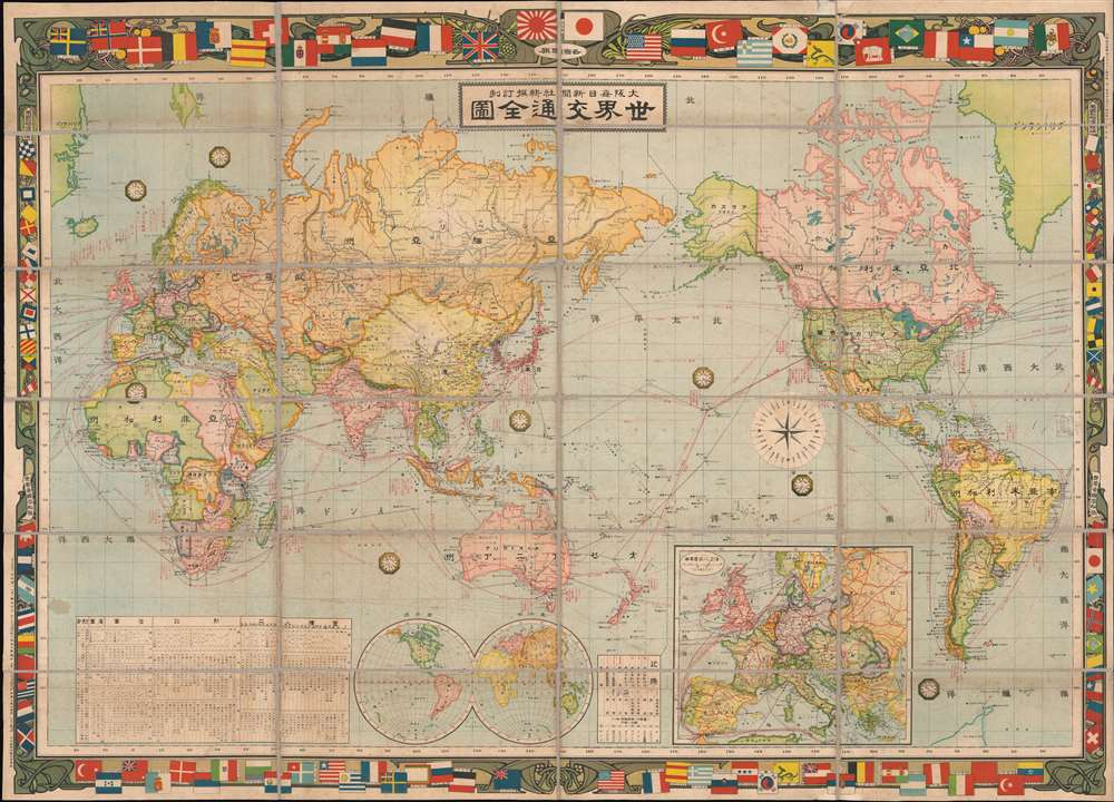
世界交通全图 / World Traffic Map. / Sekai kōtsū zenzu.
1909 (dated) 31 x 43 in (78.74 x 109.22 cm)
1909 (dated) 31 x 43 in (78.74 x 109.22 cm)
Description
An exceptional 1909 or Meiji 42 Osaka Daily News Agency map of the world on Mercator's Projection. The map embraces an art nouveau aesthetic with regard to its decorative borders, which incorporate the flags and ensigns of the world's powers, among them the Azure Dragon flag of the Qing. The whole is centered on Japan and the Pacific and includes shipping routes throughout the world. Statistical tables in the lower quadrants advance detail regarding the land, population, fiscal revenue, and armaments of each nation.
Japan defines itself on the World Stage
This map was issued during a period of relative peace followed the aggressive Japanese expansionism of the First Sino Japanese War (1894 - 1895) and the Russo-Japanese War (1904 - 1905). Japan was consolidating its new territories in Taiwan, Korea, and the Liaodong Peninsula, establishing industrial and social underpinnings as well as asserting its pollical, military, and economic place in the world. This map is meant to illustrate to the citizens of Japan, and to the world, Japan's modernization, including its adoption of master of western cartographic styles. The choice of an art nouveau border suggests affiliation with European aesthetic movements. The placement of the flags, with Japan's two flags (the Rising Sun and the Nisshōki/Hinomaru, located between the Union Jack of the United Kingdom and the United States Stars and Strips flag, placing Japan among the preeminent world powers.The Qing Azure Dragon
This map includes the rare Azure Dragon on a yellow field flag of the Qing dynasty. The Azure Dragon emblem was adopted in the late 19th century and became the first national flag of China, colloquially known as the 'Yellow Dragon Flag' (黄龙旗). The flag appeared in various shapes, but the rectangular version shown here was used from 1889, when it was selected by Empress Dowager Cixi, to 1912, when Sun Yat-sen determined it inappropriate to use the traditional imperial color to represent Qing Manchu ethnicity.Publication History and Census
This map was printed in Osaka, Japan by the Osaka Mainichi Shimbun. It was prepared by Kenzō Nakamura (中村謙三) and drafted by Gotō Shichirōemon (後藤七郎右衛門). We are aware of examples at the Library of Congress and at U.C. Berkeley.CartographerS
The Osaka Mainichi Shimbun (大阪毎日新聞; 1876 - 1942) was an Osaka based daily newspaper active in the late 19th and early 20th century. The Osaka Mainichi Shimbun (大阪毎日新聞, Osaka Daily News) was founded in 1876 as Osaka Nippo(大阪日報). In 1888 it was renamed Osaka Mainichi Shimbun. In 1911 it merged with the Tokyo Nichi Nichi Shimbun (東京日日新聞), but both companies continued to print their newspapers independently until 1943, they were consolidated under the Mainichi Shimbun (毎日新聞, Daily News) masthead. The Mainichi Shimbun is today one of Japans larges and longest lasting newspapers. More by this mapmaker...
Gotō Shichirōemon (後藤七郎右衛門, fl. c. 1886 - 1911) was a Japanese cartographer active in Osaka during the early 20th century. His later work is commonly associated with the Osaka Mainichi Shimbun. His is most likely a descendent of the great Japanese swordmaker Goto Ichijo. Learn More...
Kenzō Nakamura (中村謙三, fl. c. 1900 - 1911) was a Japanese map editor active in Osaka with the Osaka Mainichi Shimbun. Learn More...
Condition
Good. Some wear on origina fold lines. Linen refreshed. Overall toning and light soiling.
References
Library of Congress, Map Division, G3200 1909 .G6 Rolled. OCLC 21788629.