This item has been sold, but you can get on the Waitlist to be notified if another example becomes available, or purchase a digital scan.
1478 / 1507 Ptolemaic Map of the World
World-ptolemy-1507$47,500.00


Title
Untitled Map of the World.
1507 (undated) 13 x 21.5 in (33.02 x 54.61 cm)
1507 (undated) 13 x 21.5 in (33.02 x 54.61 cm)
Description
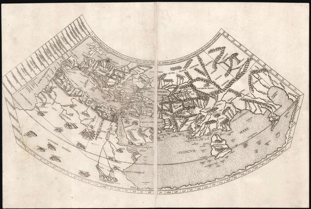
A foundational work of Renaissance cartography: this is the first, acquirable, printed map attempting a measured representation of the known world. The world map from the Rome edition of Ptolemy, in its 1478 printing it is preceded only by the unacquirable 1477 Bologna Ptolemy, the Medieval mappamundi of the Rudimentum Novitorum and the schematic 1472 Isidorus T-O map. Ptolemy's second-century innovation in representing the three-dimensional world with a grid on a projection, using mathematical methods to produce an accurate map, provided the basis of all modern cartography. Of all the early, printed versions of Ptolemy's maps, those produced for the Rome edition are considered to be the finest until Mercator's 1578 edition of the work.
Along the northern coast of the Indian Ocean can be seen the Malay Peninsula, and an oddly shrunken Indian Peninsula appears between the rivers Indus and Ganges. South and to the west of this is a massive island, Taprobana, which would be variously identified by scholars as Sri Lanka or Sumatra over the course of the sixteenth and seventeenth centuries.
The Engraver
This map, and all of those for the 1478 and 1490 editions of the Rome Ptolemy, was engraved by Konrad Sweynheim (or Schweinheim), a German printer who worked with Gutenberg in the early 1460s and who later set up the first press in Italy. Sweynheim's engravings were probably prepared prior to those of the 1477 Bologna Ptolemy and are consequently the earliest engraved copperplate maps. Moreover, the text of the printed maps was executed with the innovative use of movable type stamped directly into the copperplate, making the text both extremely uniform and legible. The work was far superior to the manuscript editions available prior to it, and indeed according to Skelton.The cleanness and precision with which geographical details are drawn; the skill with which the elements of the maps are arranged according to their significance, the sensitive use of the burin in working the plates - these qualities, in strong contrast to the careless design and crude cutting of the Bologna maps, seem to point to the hand of an experienced masterBeyond Sweynheim's superiority to his contemporary engraver, the fine detail afforded by the copperplate process allowed the maps of the Rome Ptolemy to contain more legible detail than any of the manuscript and woodcut maps produced north of the Alps in the late fifteenth and early sixteenth centuries. Nordenskiöld spotted the improvements:
They are based on the copies by Donis (Germanus) of Ptolemy's maps, but the style of the drawing is here greatly improved. Whilst, for instance, a very practical and convenient manner of indicating the mountains is used on these maps, Donis... only marked the mountain ranges by encircling lines. In uncoloured maps one was thus likely to confound mountains and seas, but this is no longer to be apprehended with the plain and handsome topographical dressing used in the maps of Schweinheim-Buckinck.
The Projection
Ptolemy's work is most important in that it distinguishes between chorography - regional mapping - and geography, which was concerned with understanding and measuring the known world, and representing those measurements graphically. Ptolemy proposed two new types of projection in order to represent the known portions of the spherical world in two dimensions. The first, conic projection, is based on a cone tangent to the Earth at the 36° parallel, showing the meridians as straight lines that tend to close towards the poles, and showing parallels as concentric arcs. The second, more complex projection modifies the conic projection by presenting the meridians as curving inwards towards the poles. The projection employed for the maps of the 1478 Ptolemy used the first, simple conic projection, as exhibited here. Sweynheim labels Ptolemy's latitudes and longitudes at the top, bottom, and right-hand borders of the map. Along the left-hand are more detailed labels of the climate zones, including the hours of daylight at the solstice at given latitudes.Ptolemy's Grid
Ptolemy's great innovation was in the idea that features of the world - cities, mountains, rivers, seas and so forth - could have their relative locations fixed by measuring the distances between them, and that these could be marked on a grid, thus providing a mathematically correct representation of the globe on a flat surface. All modern cartography developed from this understanding. Ptolemy's data, of course, was that which was available to a second-century Alexandrian: with the result that Ptolemy's work painted a picture using second century European placenames, limited by that era's European exploration and knowledge of the world, and the era's limited ability to accurately measure distances. The picture of the world thus presented is necessarily distorted, despite the utility and importance of the methodology.The Map
The Ptolemaic conic projection is a representation of only the known inhabited world, the Oikoumene. Its westernmost limit is the 'Fortunate Isles' in the Atlantic Ocean and to the east, the projection ends at China (Sinarum Regnum). The map shows from 63 degrees north, to 14 degrees south: the map thus encompasses the British Isles as the northernmost limit of Europe, while the southern limits of the map pass far beyond those areas familiar to second-century travelers, and well into the realm of speculation and legend.The Fortunate Islands
The prime meridian of our era - the longitude line we mark 'zero' - is at Greenwich, England; when the French were dominant in geography, maps placed it at Paris. The Spanish tended to place it at Tenerife. Ptolemy's prime meridian is placed among the Fortunate Isles: semi-legendary islands in the Atlantic Ocean, a sort of terrestrial paradise for Greek mythological heroes. Greek scholars - having failed to identify suitable islands corresponding to such places in the Mediterranean - placed these islands in the Atlantic. Philostratus, Plutarch, and Pliny the Elder would describe the islands in detail, and so their reports would be embraced as fact by Ptolemy. Today we recognizes that the Fortunate Isles likely represent the Azores or Canary Islands.The Indian Ocean and the Sinus Magnus
The Indian Ocean is presented as a massive, inland sea. Note that at the southern limits of eastern Africa, Ptolemy's 'Prassum Promont', the coastline turns sharply to the east and continues until it turns north, ultimately meeting the Asian coastline at China beyond the Malay Peninsula, or 'Aurea Chersonesus.' The portion of the Indian Ocean enclosed beyond the peninsula, Ptolemy termed the Great Bay, or 'Magnus Sinus.' One of the most important tasks of discovery-era mapmaking would be to reconcile Ptolemy's authoritative model with the new evidence of the shape of the world based on contemporary exploration. The Portuguese journeys around Africa proved that the land connection between China and Africa around the Indian Ocean did not exist: what, then, was the extent of the Magnus Sinus? Did land reach around it to the south from China? Was the ocean discovered by Magellan's voyage the same body of water as this? Was the mysterious coastline at the eastern limit of Ptolemy's knowledge the same as the west coast of the Americas? All European geographical thinking about the Pacific Ocean and the nature of the American discoveries began from a foundation of knowledge encapsulated in this map.Along the northern coast of the Indian Ocean can be seen the Malay Peninsula, and an oddly shrunken Indian Peninsula appears between the rivers Indus and Ganges. South and to the west of this is a massive island, Taprobana, which would be variously identified by scholars as Sri Lanka or Sumatra over the course of the sixteenth and seventeenth centuries.
Africa and The Nile
Northern Africa was nearly as well understood by Ptolemy as was Europe itself: all fell within the bounds of the Roman Empire. Beyond the great African deserts, however, lay mysteries which remained poorly illuminated well beyond the Age of Discovery. Ptolemy's sources told him of the sources of the Nile - found in the lakes of the imaginary Mountains of the Moon. This representation remained unchallenged on maps of Africa until the end of the 17th century. In the early sixteenth century, travelers' reports such as those from Leo Africanus improved on Ptolemy's model incrementally, but in large part the starting point as shown here remained authoritative well into the seventeenth century.The Mysteries of Scythia and the East
The Indies and Africa were not the only lands draped in obscurity for classical Alexandrian scholars. Beyond the Black Sea to the north and east, Ptolemy's geography grows less and less detailed. The regions of Scythia, Serica, and the Imaum mountains were - to Ptolemy's era - the domain of little-known nomadic peoples, often reputed cannibals. The Persian kingdoms of Sogdiana, Bactriana, Parthia and so on are relatively well-detailed but the Caspian, or Hyrcanian, Sea is shown distorted into an east-west oval which would not be corrected in European geography until the 18th century. Marco Polo's semilegendary reports would begin to correct elements of Ptolemy's eastern Asian geography, but not as reflected here.The Errors Are Also Important
Despite its antiquity at the time it finally made print, the Rome Ptolemy was broadly influential, most significantly perhaps in its connection to Christopher Columbus. The Italian explorer is known to have owned a copy of the 1478 Ptolemy. Among the consequences are that Columbus shared Ptolemy’s gross underestimation of the Earth’s circumference. Ptolemy's error - as expressed on this map - led Columbus to assume the great western ocean could be easily crossed. Had there been no intervening continent between Europe and the Indies, Columbus' ships would likely never have been seen again. Also, by sharing Ptolemy's disregard of Erastothenes' much more accurate measure of the globe's size, Columbus put himself at odds with the court scholars. Their argument, however, was not that they disagreed about the sphericality of the globe, but that they agreed with Erastothenes' assessment of the globe (i.e., were correct about it) and Columbus did not (i.e., was wrong).Watermarks and Dating the Rome Ptolemy
The watermarks in the paper on which these maps are printed are the only possible means for identifying specific editions, and even this has been an area of conflicting evidence. Peerlings, Laurentius, and Bovencamp in their article The Watermarks in the Rome Editions of Ptolemy's Cosmography and More make strides in resolving the issue. In their findings, the 1478 edition of the map is indicated by the presence solely of a specific 'crossbow' watermark. Later editions show an array of others: for example, the 1490 by a cardinal's hat, sometimes accompanied by sheets with a fleur de lis. A crown watermark can also be found in the 1490 edition. Several variations of a 'crossed-arrows' watermark are found starting in 1490, with a distinctive one appearing in 1507. This latter can be seen on the right-hand sheet of the present map, in the vicinity of 'India Intra Gangem.' We apply a 1507 date on the basis of this watermark.Publication History and Census
This map was first engraved for publication in the 1478 Arnold Buckinck edition of Ptolemy's Geography (which had, in the 15th century, become more widely known under the title Cosmography). Skelton estimated that the 1478 edition of the work was limited to 500 copies; subsequent editions are unlikely to have been much larger than 1000. Later editions were printed by Petrus de Turre in 1490, and by Bernardinus Venetus de Vitalibus in 1507 and 1508. We see sixteen examples of both Vitalibus editions of Ptolemy in institutional collections; McGuirk's 1989 census of the Ruysch map (the modern map accompanying this one in the 1507-1508 editions of the Rome Ptolemy) only identified 64 examples in institutional and private collections, and it is reasonable to assume that a similar number or fewer of this edition of the Ptolemaic world survive.CartographerS
Claudius Ptolemy (83 - 161 AD) is considered to be the father of cartography. A native of Alexandria living at the height of the Roman Empire, Ptolemy was renowned as a student of Astronomy and Geography. His work as an astronomer, as published in his Almagest, held considerable influence over western thought until Isaac Newton. His cartographic influence remains to this day. Ptolemy was the first to introduce projection techniques and to publish an atlas, the Geographiae. Ptolemy based his geographical and historical information on the "Geographiae" of Strabo, the cartographic materials assembled by Marinus of Tyre, and contemporary accounts provided by the many traders and navigators passing through Alexandria. Ptolemy's Geographiae was a groundbreaking achievement far in advance of any known pre-existent cartography, not for any accuracy in its data, but in his method. His projection of a conic portion of the globe on a grid, and his meticulous tabulation of the known cities and geographical features of his world, allowed scholars for the first time to produce a mathematical model of the world's surface. In this, Ptolemy's work provided the foundation for all mapmaking to follow. His errors in the estimation of the size of the globe (more than twenty percent too small) resulted in Columbus's fateful expedition to India in 1492.
Ptolemy's text was lost to Western Europe in the middle ages, but survived in the Arab world and was passed along to the Greek world. Although the original text almost certainly did not include maps, the instructions contained in the text of Ptolemy's Geographiae allowed the execution of such maps. When vellum and paper books became available, manuscript examples of Ptolemy began to include maps. The earliest known manuscript Geographias survive from the fourteenth century; of Ptolemies that have come down to us today are based upon the manuscript editions produced in the mid 15th century by Donnus Nicolaus Germanus, who provided the basis for all but one of the printed fifteenth century editions of the work. More by this mapmaker...
Konrad Sweynheim (died 1477) was a German printer and engraver. Nothing is known of his early years. It is believed that he worked with Johannes Gutenberg between 1461 and 1464 and was instrumental in the early development of printing in Europe. He, along with Arnold Pannartz, is credited with having introduced Gutenberg's invention, the mechanical movable-type printing press, to Italy. The two printers first worked in Subiaco, printing a Donatus which has not survived. The earliest surviving book printed in Italy by them was Cicero's De oratore, printed in 1465. During the course of their early works, they abandoned the German typefaces they had worked with, becoming the first to print in Roman lettering. Sweynheim and Pannartz settled in Rome in 1467, working prolifically - but unsuccessfully: nobody wanted to buy their books, until they began receiving Church assistance in the early 1470s. At this point the two parted ways, after which Sweynheym took up copperplate engraving. He engraved the maps for the superb Rome Ptolemy but did not live to see the work through to its publication. This was completed by his fellow German printer Arnold Buckinck. The Rome Ptolemy was the second to be published containing maps engraved in copper, preceded only by the Bologne Ptolemy of 1477 (though it is probable that the copperplates were completed prior to those of the 1477.) An interesting idiosyncrasy of Sweynheim's work was that the text on the maps was not engraved by hand but stamped into the printing plate with specially made letters, the oldest known use of this technique for this purpose. Learn More...
Bernardino Vitali or Bernardinus de Vitalibus (fl. 1494 to 1539) was an Albanian printer and publisher, active in Venice but also operating presses in Rome and Rimini. In the first half of the 16th century, he published more than 200 Venetian humanist works. His early life is not understood, although he is thought to have been a refugee - settling in Venice after northern Albania fell to the Ottoman Empire. His Venice print shop opened in 1494, later opening shops in Rome and Rimini. Among his publications were the 1507 and 1508 editions of the Rome Ptolemy, which contained several new maps added to those from the 1478-90 editions: most notably, the famous Ruysch world map. Learn More...
Source
Ptolemy, C., In hoc opere haec continentur Geographiae Cl. Ptolemaei a plurimis uiris utriusq[ue] linguae doctiss. eme[n]data, et cu[m] archetypo Graeco ab ipsis collata, (Rome: Vitalibus) 1507-8.
Condition
Very good. Printed to two sheets, backed and trimmed (with extremely slight loss at extreme of western border) at time of binding as indicated by edge coloring. Sheets joined for presentation.
References
OCLC: 743299316 Shirley, Rodney W., The Mapping of the World: Early Printed World Maps 1472-1700, #4. Skelton, R. A., Introduction to Facsimile edition of 1478 Rome Ptolemy, v-xiii. Suarez, T., Shedding the Veil, pp. 20-23. Peerlings, R. H. J. / Laurentius, F. / Bovenkamp, J. van den, 'The Watermarks in the Rome Editions of Ptolemy’s Cosmography and More' in Quaerendo, # 47, 2017.