1750 Schreiber Double Hemisphere Map of the World
World-schreiber-1741$750.00
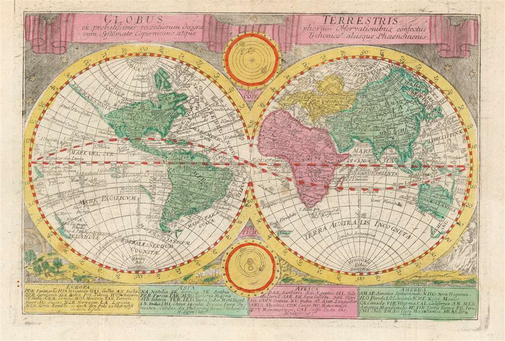

Title
Globus Terrestris: ex probatissimis recentorum Geographorum Observationibus confectus cum Systemate Copernicano atque Tychonico aliisque Phenomenis.
1741 (undated) 6.25 x 9.25 in (15.875 x 23.495 cm) 1 : 185000000
1741 (undated) 6.25 x 9.25 in (15.875 x 23.495 cm) 1 : 185000000
Description
This is the double-hemisphere world map from Johann Georg Schreiber's Atlas Selectus, a student published from around 1741 until his death. It presents the world in a pre-Cook form. Australia and New Zealand are only shown by their western coasts as per Abel Tazman, and the American Pacific Northwest is shown as an extended unexplored coastline with California attached. The northeastern coast of Asia is shown with the Anadirskoe Sea separating it from North America. These features tend to identify Homann's Planiglobii Terrestris as Schreiber's source - particularly given certain specific textual elements shared by both maps, such as the identification of an uncertain Pacific coastline as 'Terra quam credit Mendana esse Novam Guineam.' ('The land which Mendaña believed was New Guinea')
The bottom of the engraving contains a key which, for each of the four continents, deciphers the abbreviations used on the map to name regions legibly.
Decorative Elements
The map's primary hemispheres are bordered with engravings of the starry sky, and natural scenes including waterspouts, rainbows, and a volcano. There are two ancillary diagrams of the solar system, one depicting the still-controversial Copernican model (Galileo’s Dialogue and Copernican books in general would only be partially unbanned by Pope Benedict XIV in 1758) and the other depicting Brahe's compromise model which avoided Papal ire by retaining the Earth's place in the center of the universe.The bottom of the engraving contains a key which, for each of the four continents, deciphers the abbreviations used on the map to name regions legibly.
Publication History and Census
This map was engraved by Schreiber for inclusion in his Atlas Selectus. Some institutions have catalogued this book with dates as early as 1725. However, Zbigniew Paprotny (in his 2020 article in the Polish Cartographical Review) dates the first edition of the Atlas Selectus as 1741. This map appeared in every edition with no changes of substance, as late as 1790.CartographerS
Johann Georg Schreiber (December 10, 1676 - July 31, 1750) was a German engraver, cartographer, and publisher. He was the first map publisher in Saxony and produced much of his work in the city of Leipzig where he resettled and where he was at the time of his death. He was born the sixth of seven children to Hans and Anna Schreiber in Spremberg. His father was a carpenter. Details of his education are not known, but he was likely apprenticed as an engraver, since he was commissioned to draw and engrave a city plan of Bautzen in 1700. He continued to produce city views and plans, especially of Leipzig, between about 1709 and 1740. In 1741 he published his only bound work, Atlas Selectus von allen Königreichen und Ländern der Welt, editions of which continued in print well after his death in 1750. His widow continued the business with his son Johann Christian Schreiber. More by this mapmaker...
Johann Baptist Homann (March 20, 1664 - July 1, 1724) was the most prominent and prolific map publisher of the 18th century. Homann was born in Oberkammlach, a small town near Kammlach, Bavaria, Germany. As a young man, Homann studied in a Jesuit school and nursed ambitions of becoming a Dominican priest. Nonetheless, he converted to Protestantism in 1687, when he was 23. It is not clear where he mastered engraving, but we believe it may have been in Amsterdam. Homann's earliest work we have identified is about 1689, and already exhibits a high degree of mastery. Around 1691, Homann moved to Nuremberg and registered as a notary. By this time, he was already making maps, and very good ones at that. He produced a map of the environs of Nürnberg in 1691/92, which suggests he was already a master engraver. Around 1693, Homann briefly relocated to Vienna, where he lived and studied printing and copper plate engraving until 1695. Until 1702, he worked in Nuremberg in the map trade under Jacob von Sandrart (1630 - 1708) and then David Funck (1642 - 1709). Afterward, he returned to Nuremberg, where, in 1702, he founded the commercial publishing firm that would bear his name. In the next five years, Homann produced hundreds of maps and developed a distinctive style characterized by heavy, detailed engraving, elaborate allegorical cartouche work, and vivid hand color. Due to the lower cost of printing in Germany, the Homann firm could undercut the dominant French and Dutch publishing houses while matching their diversity and quality. Despite copious output, Homann did not release his first major atlas until the 33-map Neuer Atlas of 1707, followed by a 60-map edition of 1710. By 1715, Homann's rising star caught the attention of the Holy Roman Emperor Charles VI, who appointed him Imperial Cartographer. In the same year, he was also appointed a member of the Royal Academy of Sciences in Berlin. Homann's prestigious title came with several significant advantages, including access to the most up-to-date cartographic information as well as the 'Privilege'. The Privilege was a type of early copyright offered to very few by the Holy Roman Emperor. Though less sophisticated than modern copyright legislation, the Privilege offered limited protection for several years. Most all J. B. Homann maps printed between 1715 and 1730 bear the inscription 'Cum Priviligio' or some variation. Following Homann's death in 1724, the firm's map plates and management passed to his son, Johann Christoph Homann (1703 - 1730). J. C. Homann, perhaps realizing that he would not long survive his father, stipulated in his will that the company would be inherited by his two head managers, Johann Georg Ebersberger (1695 - 1760) and Johann Michael Franz (1700 - 1761), and that it would publish only under the name 'Homann Heirs'. This designation, in various forms (Homannsche Heirs, Heritiers de Homann, Lat Homannianos Herod, Homannschen Erben, etc.) appears on maps from about 1731 onwards. The firm continued to publish maps in ever-diminishing quantities until the death of its last owner, Christoph Franz Fembo (1781 - 1848). Learn More...
Source
Schreiber, J. G. Atlas selectus von allen Konigreichen und Landern der Welt Leipzig, c. 1750.
Condition
Very good. Original fold lines visible; original wash color.
References
OCLC 159805422. Rumsey 11208.004.