1660 / 1702 van Meurs / Vander Aa Map of the World
World-vanderaa-1702$1,750.00

Title
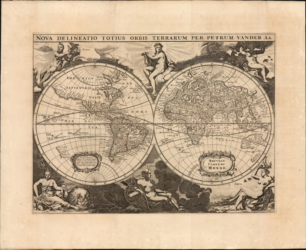
Nova Delineatio Totius Orbis Terrarum Per Petrum Vander Aa.
1702 (undated) 10 x 13.75 in (25.4 x 34.925 cm) 1 : 150000000
1702 (undated) 10 x 13.75 in (25.4 x 34.925 cm) 1 : 150000000
Description
This elegant double-hemisphere map of the world, engraved in 1660 by Jacob van Meurs, encapsulates the European understanding of the world during the second part of the 17th century. It is notable as well for its stately decorative imagery.
The southern hemisphere does not derive from Colom's map, being updated to reflect the discoveries of Abel Tasman (c. 1603 - 1661), including western Australia, Tasmania, and New Zealand. Tasman's discoveries, as evident here, were not improved upon until Captain James Cook's 1768-71 voyage. Meurs also appears to be benefiting from the work of Frederick De Wit: either from De Wit's edit of the Colom (as described by Rodney Shirley with respect to the 1655 map, #395 in The Mapping of the World) or De Wit's own 1660 Nova Totius Terrarum Orbis Tabula. Both maps include Tasman's geography, and his treatment of the New Zealand coastline is distinctive enough to rule out other possible sources.
A Closer Look
The geographical details reflect the knowledge of the mid-17th century. In North America, California is presented as an island, and the Great Lakes and the Mississippi River do not appear. Gaps in the coastlines of Hudson Bay and beyond in the Canadian Arctic offer tantalizing possibilities of a Northwest Passage. The phantom island of Frisland appears in the North Atlantic. North of Europe and Asia, Spitzbergen and a partial Nova Zembla appear, and little seems to impede a Northeast Passage. Korea appears as a peninsula; Japan is incompletely presented, with no defined northern coastline and no Ieso/Hokkaido present. These details are all consistent with Meurs' predominant source for this map, Arnold Colom's 1655 Nova Delineatio Totius Orbis Terrarum.The southern hemisphere does not derive from Colom's map, being updated to reflect the discoveries of Abel Tasman (c. 1603 - 1661), including western Australia, Tasmania, and New Zealand. Tasman's discoveries, as evident here, were not improved upon until Captain James Cook's 1768-71 voyage. Meurs also appears to be benefiting from the work of Frederick De Wit: either from De Wit's edit of the Colom (as described by Rodney Shirley with respect to the 1655 map, #395 in The Mapping of the World) or De Wit's own 1660 Nova Totius Terrarum Orbis Tabula. Both maps include Tasman's geography, and his treatment of the New Zealand coastline is distinctive enough to rule out other possible sources.
The Decorative Engraving
The very distinctive figures appearing around the hemispheres are derived from the 1655 Colom map. They are atypically simple: six statuesque figures, each alone in its realm. The corner figures represent the elements of Earth, Air, Fire, and Water. The two central figures at the top and bottom are Apollo and Diana, representing Day and Night, respectively.Publication History and Census
This map was engraved by Jacob van Meurs in 1660 for inclusion in Johann Gottfried's Historische Chronyck. When the book was republished in 1698 by Vander Aa as Historische Kronyck, it was altered to replace Meurs' imprint with Vander Aa's; the cartouche was also changed to read Niewe Werelt Caart. That second state was changed once again for the 1702 printing of Historische Kronyck, this third state's (present example) cartouche reading Nouveau Carte du Monde. The separate map appears only a handful of times in OCLC, but comes to market from time to time. Historische Kronyck is well represented in institutional collections.CartographerS
Jacob van Meurs (c. 1620 - 1680) was a Dutch engraver active in Amsterdam during the second half of the 17th century. Van Meurs is best known for his collaboration with Arnoldus Montanus in the publication of numerous engraved maps and views for Montanus' various influential histories and travel narratives. Some of his most important works include a few of the earliest known views of the Americas (including New York City), Japan, and China. More by this mapmaker...
Pieter van der Aa (1659 - 1733) was a Dutch publisher of maps and atlases active in the late 17th and early 18th centuries. Van der Aa was born in Leyden in 1659. At nine he was apprenticed to a local bookseller and, by 21, had established his own publishing, printing, and auctioneering house. In 1692 Van der Aa was appointed to be one of the High Commissioners of the Booksellers Guild. During his long and impressive career Van der Aa produced thousands of maps, including a vast 28 volume atlas containing no less than 3,000 maps. Few of Van der Aa's maps were original productions, most being copied from the work of earlier cartographers. Nonetheless, when one of Van der Aa's rare original pieces does appear, his style, with unusual projections, elegant engraving, and precise detail, is instantly recognizable and highly desirable. He also pioneered the cartographic idea of separating border artwork from the map plate itself such that every map in a collection could have a similar elaborate border without actually having to re-engrave the complex plates. This technique was used to great effect by later 18th century publishers like Brion de la Tour. Following Van der Aa's death in 1733, his much admired Nouvel Atlas was reissued by the Dutch firm of Covens & Mortier. Today Van der Aa's work is admired for its fine delicate engraving and unusual projections and is considered highly desirable among collectors. Learn More...
Source
Gottfried, J. L., Historische Kronyck, (Leyden: Van Der Aa) 1702.
Condition
Excellent. Visible folds, else fine.
References
OCLC 994031331. Shirley, R. The Mapping of the World #417.