
This item below is out of stock, but another example (left) is available. To view the available item, click "Details."
Details
1665 / 1689 Frederick de Wit Double Hemisphere Map of the World
1665 (undated) $6,000.00
1665 / 1689 Frederick de Wit Double Hemisphere Map of the World
World-wit-1665-2$3,250.00

Title
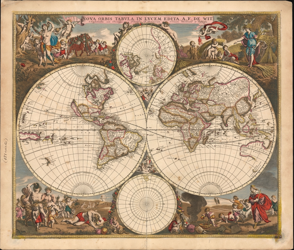
Nova Orbis Tabula In Lucem Edita, A. F. de Wit.
1665 (undated) 18.25 x 21.5 in (46.355 x 54.61 cm) 1 : 90000000
1665 (undated) 18.25 x 21.5 in (46.355 x 54.61 cm) 1 : 90000000
Description
This is a striking c. 1689 example, in original color, of Frederick De Wit's classic double hemisphere map of the world. Shirley praised it as 'one of the most attractive of its time'. It features many of the tropes of 17th-century Dutch mapmaking: Isular California, imaginary islands, etc., as well as new discoveries, such as Western Australia, and cartographic reconsiderations, among them the removal of the imaginaryTerra Australis.
New Mexico's Rio del Norte is conflated with the Colorado River, petering out to the west rather than emptying into the Gulf of Mexico. De Wit's map includes a prominent insular California, expressing an accepted geographical truth of the day. The Pacific coastline is incomplete, leaving hope for a northwest passage connecting to Hudson's Bay. Notably, the north Pacific - from De Vries' Compagnie's Landt in the west to Anian in the east - is empty, revealing the lack of data in eloquent silence.
At its first printing, the cusps of the hemispheres were left blank. In 1680, these spaces were filled up with more putti; those in the upper cusp mimic the winds, puffing away; those in the lower cusp mimic the seasons, bearing symbols identifying them with the vignettes more elaborately celebrated in the corner decoration of the map.
A Closer Look
De Wit's map presents the state of the art of Dutch mapmaking as expressed in Nicolas Visscher's 1658 map of the world, its detail drawn primarily from Joan Blaeu's Nova et Accuratissima Totius Terrarum Orbis Tabula. In both its geographical detail and the composition of its primary and subordinate hemispheres, it references Visscher.Dating
Shirley tentatively dated the first issue of this map at c. 1670, but its content - particularly compared with De Wit's other world maps - suggests it was engraved earlier, although not before 1660, as it was intended as an update to the mapmaker's 1660 world map (Shirley 421). Despite Shirley's date, it thus seems reasonable to assign it a date earlier than 1668. De Wit's map of that year exhibited geographical details that do not appear here, and it is unlikely that such improvements would be lightly abandoned. Once published, the map remained in De Wit's atlases with no cartographic changes.The South
As was typical in the second half of the 17th century, De Wit dispenses with the Terra Australis Incognita that dominated the South Pole of earlier maps, but which mariners consistently failed to find. The south polar projection is starkly empty, apart from a portion of Patagonia and a full-coastlined Tierra del Fuego. The oft-imagined southern continent is replaced in the primary hemispheres by the inclusion of Abel Tasman's discoveries of Australia and New Zealand's western coastlines in 1642 and 1644.The North
The guesswork and legend that informed the 16th-century mapping of the North have been replaced with the concrete results of exploration. Mercator's four Arctic landmasses are gone, as is the fraudulent Zeno cartography, which dominated the mapping of the North Atlantic in the first part of the 17th century. Greenland is mapped with the Davis Strait, and James' Bay is recognizably charted. The efforts of Dutch whalers are recorded in the mapping of Spitzbergen. Nova Zembla appears as an island, although its eastern shore is not yet charted. The northeastern extremes of Asia are still ill-formed, awaiting the efforts of Witsen and other mapmakers of the late 17th century.Buss Island
Although Zeno's Frisland, Icaria, and Estotiland have been removed, in the north polar projection another phantom island - Buss Island - has been added. Sailors on the 1578 third expedition of Martin Frobisher, navigating on the ship Emanuel (a class of ship known as a busse) recorded the sighting of an island in the ocean between Ireland and Zeno's fraudulent Frisland. It is thought that Frobisher's Frisland was actually southern Greenland, that what he thought was Greenland was Baffin Island, and that the location of the newly discovered Buss Island was in the wrong place (57°N rather than probably 62°N) and was furthermore an optical effect, rather than actual land. Despite this, in 1671, Thomas Shepard claimed that not only was the island real, but they also explored and mapped it. In 1745, it was proposed that the island was real but had sunk. In 1818, its existence was disproved by John Ross, who, during his first Arctic expedition, plumbed the waters of its alleged location to a depth of 180 fathoms (330 m), finding no bottom.North America
The east coast of North America is increasingly more recognizable. Cape Cod is recognizable, Virginia is named, and the barrier islands of the Carolinas are discernable. The interior is virtually unknown, although this is among the earliest world maps to have a large, distinct lake associated with the St. Lawrence River, albeit with no western shore. De Wit's use of the Blaeu cartography for the Great Lakes, in particular, gives us reason to suggest a date for this map before De Wit's 1668 world map, which shows the Great Lakes modeled after Nicolas Sanson's map of 1660. (The 1668 map's Australia and New Zealand also closely resemble that of the Sanson.)New Mexico's Rio del Norte is conflated with the Colorado River, petering out to the west rather than emptying into the Gulf of Mexico. De Wit's map includes a prominent insular California, expressing an accepted geographical truth of the day. The Pacific coastline is incomplete, leaving hope for a northwest passage connecting to Hudson's Bay. Notably, the north Pacific - from De Vries' Compagnie's Landt in the west to Anian in the east - is empty, revealing the lack of data in eloquent silence.
A Lively and Beautiful Engraving
If Visscher's 1658 map established a new standard for the decoration of maps, De Wit appears to have been equal to the challenge. As derivative as his geography may have been, the artistry of his borders and their themes were fresh and playful. While Visscher's decorative scenes depict the elements, De Wit's lively vignettes depict the seasons and cleverly insert seasonal Zodiacal symbols. Spring, for example, surrounds Venus and Cupid with a horde of putti wrangling a garlanded bull and a stubborn ram. Winter features the titular Old Man of the season. With him, the ubiquitous pudgy angels wrestle Capricorn's goat, while another displays a pair of fish (Pisces), and another fills a basin of water (Aquarius). Autumn features a riotous band of satyrs. They carry one drinker aloft while another, defeated by his wine, suffers the inevitable result of his excess sprawled on the grass. A Sagittarian centaur hunts in the background. In the crowd of putti attending the bacchanalia, one carries a huge scorpion by the tail, and another puzzles at Libra's scales. The summer harvest queen and her putto attendants are attended by a lion. The demure figure in the background is doubtless Virgo.At its first printing, the cusps of the hemispheres were left blank. In 1680, these spaces were filled up with more putti; those in the upper cusp mimic the winds, puffing away; those in the lower cusp mimic the seasons, bearing symbols identifying them with the vignettes more elaborately celebrated in the corner decoration of the map.
Publication History and Census
This map was engraved as early as 1662 for inclusion in De Wit's atlases. It remained in print without change from this first state until 1680, when the plate was reworked. That second state of the map included decoration in the cusps of the hemispheres and the border. The present example is of a third state, which includes De Wit's privilege, of which these examples must be dated to 1689 or later.CartographerS
Frederik de Wit (1629 - 1706) was a Dutch Golden Age cartographer active in the second half of the 17th and the early 18th centuries. De Wit was born of middle class Protestant stock in the western Netherlandish town of Gouda. He relocated to Amsterdam sometime before 1648, where he worked under Willem Blaeu. His first attributed engraved map, a plan of Haarlem for Antonius Sanderus' Flandria Illustrata, was issued around this time. He struck out on his own in 1654. The first chart that De Wit personally both drew and engraved was most likely his 1659 map of Denmark, REGNI DANIÆ Accuratissima delineatio Perfeckte Kaerte van ‘t CONJNCKRYCK DENEMARCKEN. His great wall map of the world and most famous work, Nova Totius Terrarum Orbis Tabula appeared one year later. Following the publication of his wall map De Wit quickly rose in prominence as a both cartographer and engraver. He married Maria van der Way in 1661 and through her became a citizen of Amsterdam in 1662. Around this time he also published his first major atlas, a composite production ranging in size from 17 to over 150 maps and charts. Other atlases and individual maps followed. In 1689 De Wit was granted a 15 year Privilege by the Dutch States General. (An early copyright that protected the recipient's rights to print and publish.) He was recognized with the honorific 'Good Citizen' in 1694. De Wit died in 1706 after which his wife Maria continued publishing his maps until about 1710. De Wit's son, Franciscus, had no interest in the map trade, instead choosing to prosper as a stockfish merchant. On her own retirement, Maria sold most De Wit maps and plates at a public auction. Most were acquired by Pieter Mortier and laid the groundwork for the 1721 rise of Covens and Mortier, the largest Dutch cartographic publishing house of the 18th century. More by this mapmaker...
Joan (Johannes) Blaeu (September 23, 1596 - December 21, 1673) was a Dutch cartographer active in the 17th century. Joan was the son of Willem Janszoon Blaeu, founder of the Blaeu firm. Like his father Willem, Johannes was born in Alkmaar, North Holland. He studied Law, attaining a doctorate, before moving to Amsterdam to join the family mapmaking business. In 1633, Willem arranged for Johannes to take over Hessel Gerritsz's position as the official chartmaker of the Dutch East India Company, although little is known of his work for that organization, which was by contract and oath secretive. What is known is his work supplying the fabulously wealthy VOC with charts was exceedingly profitable. Where other cartographers often fell into financial ruin, the Blaeu firm thrived. It was most likely those profits that allowed the firm to publish the Theatrum Orbis Terrarum, sive, Atlas Novus, their most significant and best-known publication. When Willem Blaeu died in 1638, Johannes, along with his brother Cornelius Blaeu (1616 - 1648) took over the management of the Blaeu firm. In 1662, Joan and Cornelius produced a vastly expanded and updated work, the Atlas Maior, whose handful of editions ranged from 9 to an astonishing 12 volumes. Under the brothers' capable management, the firm continued to prosper until the 1672 Great Amsterdam Fire destroyed their offices and most of their printing plates. Johannes Blaeu, witnessing the destruction of his life's work, died in despondence the following year. He is buried in the Dutch Reformist cemetery of Westerkerk. Johannes Blaeu was survived by his son, also Johannes but commonly called Joan II, who inherited the family's VOC contract, for whom he compiled maps until 1712. Learn More...
Condition
Good. Original color oxidized leading to cracking in some areas with slight loss; neatly mended centerfold split at bottom. Else a lovely copy with an attractive patina.
References
OCLC 558019304. Rumsey 12220.004 (1682, second state). Shirley, Rodney W., The Mapping of the World: Early Printed World Maps 1472-1700, #451.