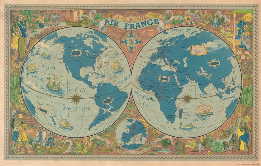
1952 Boucher Pictorial Double Hemisphere Map of the World (Unrecorded State!)
WorldAirFranceUnrecorded-boucher-1952$2,000.00


Title
Air France. Sur les Ailes d'Air France Decouvrez le Monde a Votre Tour.
1952 (dated) 24 x 37.75 in (60.96 x 95.885 cm) 1 : 29500000
1952 (dated) 24 x 37.75 in (60.96 x 95.885 cm) 1 : 29500000
Description
This is a 1952 Lucien Boucher promotional Air France map of the world, presented here in an unrecorded state, possibly in a proof state.
A Closer Look
Depicting the world in hemispheres, Boucher traces Air France's routes worldwide, with a small circular inset at bottom center focusing on Western Europe. Gold accents appear throughout, including the Suns along the Equator and in the border. The surround features illustrations of global historic events, flora, fauna, and cultures, all in a mid-century modern aesthetic.Differences in State
Color variations are the most recognizable markers of separate states. On the present example, nearly all the red in the details in the surround appear as yellow (all in printed color), including the borders for the cartouches labeling the continents. The background is also a more muted red, lending the piece a subdued air. The two pieces together (https://www.geographicus.com/P/AntiqueMap/worldairfrance-lucienboucher-1952) make a striking pair.Publication History and Census
This map was created by Lucien Boucher and printed in France by Perceval in Paris in 1952. This is the only known surviving example of this state.Cartographer
Lucien Boucher (1889 - 1971) was French cartoonist, artist, writer, and illustrator. Boucher was born in Chartres in 1889 and graduated from the École de Céramique de Sèvres. His work as a cartoonist appeared in the humorous weekly Le Rire. Starting in the 1920s he produced numerous pictorial posters inspired by the commercial promise of surrealism. Among them were a series of surrealistic planispheric and celestial maps drawn to illustrate the transportation networks of Air France. More by this mapmaker...
Condition
Good. Closed margin tears professionally repaired on verso. Closed tear extending 1 inch into printed area from left margin professionally repaired on verso.