This item has been sold, but you can get on the Waitlist to be notified if another example becomes available, or purchase a digital scan.
1832 Delamarche Map of the Ancient World: Europe, Africa, Asia
WorldAncient-delamarche-1832$50.00

Title
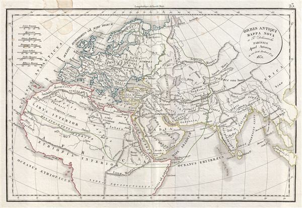
Orbis Antiqui Mappa Nova.
1832 (undated) 12 x 18 in (30.48 x 45.72 cm)
1832 (undated) 12 x 18 in (30.48 x 45.72 cm)
Description
This is a fine example of Delamarche's 1832 map of the world as known to the ancients, including europe, northern Africa and western Asian. The map shows the ancient world from the Atlantic Ocean to Burma in Asia and from the Indian Ocean to the North Sea. The map indicates the region of Sarmatia europea separated from Sarmatia Asiatica. The map also shows Scythia Intra Imaum and Scythia extra Imaum, the region of Scythia as it was known during the time of the Roman empire, divided by Mount Imaum. The map beautifully depicts the Libyan Desert and Libya Interior in Northern Africa, as well as the Arabian Desert. Various cities, towns, rivers, lakes and other topographical details are marked. This map is based upon early work by Robert Vaugondy, having been updated and corrected by his successor, Delamarche. Issued as part of Delamarche's 1832 Atlas de la Geographie.
Cartographer
Charles-François Delamarche (August 1740 - October 31, 1817) founded the important and prolific Paris-based Maison Delamarche map publishing firm in the late 18th century. A lawyer by trade, Delamarche entered the map business with the 1787 acquisition from Jean-Baptiste Fortin of Robert de Vaugondy's map plates and copyrights. Delamarche appears to have been of dubious moral character. In 1795, the widow of Didier Robert de Vaugondy, Marie Louise Rosalie Dangy, petitioned a public committee for 1500 livres, which should have been awarded to her deceased husband. However, Delamarche, proclaiming himself Vaugondy's heir, filed a simultaneous petition and walked away with the funds, most of which he was instructed to distribute to Robert de Vaugondy's widow and children. Just a few months later, however, Delamarche proclaimed Marie Dangy deceased, and it is highly unlikely that any funds found their way to Robert de Vaugondy's impoverished daughters. Nonetheless, where Robert de Vaugondy could barely make ends meet as a geographer, Delamarche prospered as a map publisher, acquiring most of the work of earlier generation cartographers Lattre, Bonne, Desnos, and Janvier, thus expanding significantly upon the Robert de Vaugondy stock. Charles Delamarche eventually passed control of the firm to his son Felix Delamarche (c. 1750 - c. 1850) and geographer Charles Dien (1809 - 1870). It was later passed on to Alexandre Delamarche, who revised and reissued several Delamarche publications in the mid-19th century. The firm continued to publish maps and globes until the middle part of the 19th century. More by this mapmaker...
Source
Delamarche, F., Atlas de la Geographie Ancienne, du moyen age, et moderne, (Paris) 1832.
Condition
Very good. Blank on verso. Original cernterfold exhibts wear and creasing. Stains in top left quadrant of the map.