This item has been sold, but you can get on the Waitlist to be notified if another example becomes available.
1936 National Geographic View from the Highest Point Above Earth (South Dakota)
WorldHighestPoint-natgeo-1936$50.00

Title
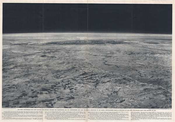
The first photograph ever made showing the division between the troposphere and the stratosphere and also the actual curvature of the Earth.
1936 (dated) 16.5 x 24 in (41.91 x 60.96 cm)
1936 (dated) 16.5 x 24 in (41.91 x 60.96 cm)
Description
This is a beautiful view issued as a supplement to the National Geographic Magazine in May, 1936. The image, taken from 72,395 feet above the surface of the Earth from a point approximately 35 miles south of Murdo, South Dakota, looks west towards the Black Hills of South Dakota, the Big Horn Mountains, and beyond. Notes rivers, mountains and some popular locations in the region.
Taken from the balloon Explorer II, the photograph was the first ever showing the division between the Troposphere and the Stratosphere and also the actual curvature of the Earth. It was also, at the time, the highest point ever reached by man. The photograph is credited to captain Albert Stevens, who along with Captain Orvil Anderson attained the height which would not be surpassed until 1956. The Stratosphere Flight was sponsored by the National Geographic Society and the U.S. Army Air Corps, on November 11, 1935. Issued as a supplement to the May, 1936 edition of the National Geographic Magazine.
Taken from the balloon Explorer II, the photograph was the first ever showing the division between the Troposphere and the Stratosphere and also the actual curvature of the Earth. It was also, at the time, the highest point ever reached by man. The photograph is credited to captain Albert Stevens, who along with Captain Orvil Anderson attained the height which would not be surpassed until 1956. The Stratosphere Flight was sponsored by the National Geographic Society and the U.S. Army Air Corps, on November 11, 1935. Issued as a supplement to the May, 1936 edition of the National Geographic Magazine.
Condition
Very good. Minor wear along original fold lines. Minor spotting.
References
OCLC: 6842435.