
This item below is out of stock, but another example (left) is available. To view the available item, click "Details."
Details
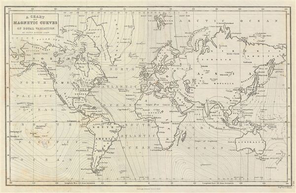
1844 Black Map or Chart of the World showing Magnetic Curves
1844 (undated) $150.00
1851 Black Map or Chart of the World's Magnetic Waves
WorldMagnetic-black-1851$75.00

Title
A Chart of Magnetic Curves of Equal Variation.
1851 (undated) 11.5 x 17 in (29.21 x 43.18 cm)
1851 (undated) 11.5 x 17 in (29.21 x 43.18 cm)
Description
This is a fine example of Adam and Charles Black's 1851 map of the world illustrating 'magnetic curves of equal variation'. The map is the product of Peter Barlow's groundbreaking research into magnetic variation. It is based on Barlow's unobtainable larger-scale chart published in 1833, A chart of magnetic curves of equal variation between the latitudes of 60°N and 55°S.
A Closer Look
The chart depicts the magnetic curves over the entire world, but does not show the isomagnetic lines over any continent except North America. It marks the northern magnetic pole at the Boothia Felix (now the Boothia Peninsula) based on the first expedition by James Clark Ross in 1831. Due to the magnetic changes in the Earth's core, the position of the magnetic pole changes over time. In 2005, it was estimated that the northern magnetic pole was positioned to the west of Ellesmere Island, Canada. It names various countries, but no boundaries are depicted.Magnetic Variation
Magnetic variation, also known as magnetic declination, has been a critical factor in navigation and cartography throughout history. This phenomenon, where the angle between geographic north and magnetic north varies over time and location, was first noted by European explorers during the Age of Discovery. In the 15th and 16th centuries, as sailors ventured further from familiar waters, the realization that compasses did not always point to true north led to significant advancements in navigation. The study of magnetic variation became crucial for accurate sea travel and mapmaking. Pioneering navigators and scientists like Christopher Columbus and Henry Gellibrand observed and documented these variations, although a comprehensive understanding of Earth's magnetic field developed much later. By the 18th and 19th centuries, with the publication of magnetic charts and the development of more precise instruments, sailors could calculate and compensate for magnetic variation, greatly improving the accuracy of long-distance sea voyages.Peter Barlow
Peter Barlow (1776 - 1862), a prominent English mathematician and physicist in the early 19th century, significantly advanced the understanding of magnetic variation, particularly in relation to its impact on naval navigation. His pivotal work focused on the challenges posed by the increasing use of iron in shipbuilding, which interfered with the accuracy of magnetic compasses. Barlow conducted extensive research on the magnetic properties of iron in ships and developed innovative methods to correct compass readings. One of his notable contributions was the introduction of 'Barlow's Plate,' a small piece of soft iron placed near the compass to counteract the ship's magnetic disturbance. This invention was crucial in reducing navigational errors caused by a ship's own magnetic fields, thereby enhancing safety and efficiency in an era marked by growing global maritime activity.Publication History and Census
The map is engraved by G. Aikman and issued as plate no. III-I in the 1851 edition of Black's General Atlas. It was issued in most editions of Black's atlas through the 1850s.Cartographer
Charles and Adam Black (fl. 1807 - present) were map and book publishers based in Edinburgh. Charles and his uncle, Adam, both of Edinburgh, Scotland, founded their publishing firm in 1807. They published a series of maps and atlases throughout the 19th century. In addition to an array of atlases, the Black firm is known for their editions of the Encyclopedia Britannica (1817 - 1826) and the first publishing of Sir Walter Scott's novels in 1854. In 1889 the A. & C. Black publishing house moved to London where it remains in operation to this day. More by this mapmaker...
Source
Black, A. and C., General Atlas Of The World, (Edinburgh) 1851.
Condition
Very good. Blank on verso. Original platemark visible.
References
Rumsey 2305.006 (1854 edition). Philips (atlases) 4334.