This item has been sold, but you can get on the Waitlist to be notified if another example becomes available, or purchase a digital scan.
1799 Cruttwell Map of the World on Mercator's Projection
WorldMercator-cruttwell-1799$225.00

Title
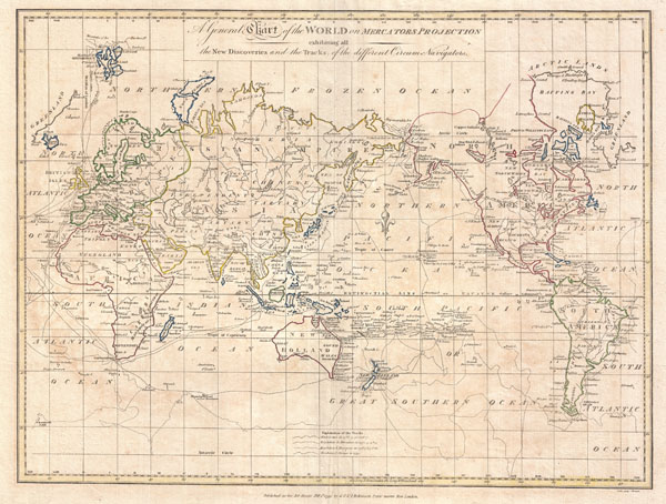
A General Chart of the World on Mercators Projection exhibiting all the New Discoveries and the Tracks of the Different Circum Navigators.
1799 (dated) 14 x 18 in (35.56 x 45.72 cm)
1799 (dated) 14 x 18 in (35.56 x 45.72 cm)
Description
A fine example of Clement Cruttwell's 1799 map of the world on Mercator's Projection. This is an elegant world map designed to illustrate the activities of important explorers of the 17th and18th centuries. The tracks of Cook, Anson, Bourgainville, Wallis, Furneaux, and others are noted. Cook's work in the late 18th century, being of extreme importance, is emphasized. Cartographically this map follows established convention but does feature the most recent discoveries of Cook and Vitus Bering in the Arctic, which are featured at top center. Inland detail is somewhat minimal and focuses on important cities and countries. There are however, a few anomalies worthy of note. Tasmania is attached to the Australian mainland. Japan is incorrectly aligned along the horizontal. The sea between Japan and Korea, the name of which is currently being disputed between Korea and Japan, is here identified as the Corean Sea. Antarctica, which has not yet been discovered when this map was drawn, is absent.
The whole exhibits delicate outline color and fine copper plate engraving in the minimalist English style prevalent in the late 18th and early 19th centuries. Drawn by G. G. and J. Robinson of Paternoster Row, London, for Clement Cruttwell's 1799 Atlas to Cruttwell's Gazetteer.
The whole exhibits delicate outline color and fine copper plate engraving in the minimalist English style prevalent in the late 18th and early 19th centuries. Drawn by G. G. and J. Robinson of Paternoster Row, London, for Clement Cruttwell's 1799 Atlas to Cruttwell's Gazetteer.
Cartographer
Clement Cruttwell (1743 - August 5, 1808) was an English book and map publisher active in Bath and London in the late 18th and early 19th century. Cruttwell was born the son of William Cruttwell, a gentleman of Wokingham, Berkshire, England. As a young man Cruttwell was educated to be an Anglican Reverend and consequently maintained a lifelong interest in religious matters. Throughout his life, he published a number of religious works and geographical gazetteers including several focused on the British Isles and one dedicated to France. Though little is known of Cruttwell today, he was highly regarded in his own time. In his obituary, a period publication, The Universal Magazine of Knowledge and Pleasure describes Cruttwell as
a gentleman whose various literary performances, for labour, extent, and utility, have rarely been equaled, and, when regarded as the productions of an unassisted valetudinarian, have perhaps never been surpassed.Cruttwell was also a known correspondent of George Washington to whom he sent his own translation of the Holy Bible, which Washington kept in his personal library until his death. More by this mapmaker...
Source
Cruttwell, C., Atlas to Cruttwell's Gazetteer, 1799.
Condition
Very good. Original centerfold. Platemark visible. Some offsetting. Moderate overall toning. Blank on verso.
References
University of Southern California, Sea of Korea Map Collection, EAMC-82.