This item has been sold, but you can get on the Waitlist to be notified if another example becomes available, or purchase a digital scan.
1861 Mitchell Map of the World on Mercator Projection
WorldMercator-mitchell-1861$100.00

Title
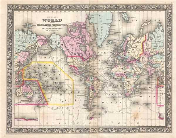
Map of the World on the Mercato Projection, Exhibiting the American Continent as its Centre.
1860 (dated) 14.75 x 18.5 in (37.465 x 46.99 cm) 1 : 100000000
1860 (dated) 14.75 x 18.5 in (37.465 x 46.99 cm) 1 : 100000000
Description
This is an 1861 Samuel Augustus Mitchell, Jr. map of the World on Mercator's projection which depicts the entire world with the American continent at its center. The routes of important explorers including Cook, the U.S. Exploring Expedition (Wilkes), the Resolution, Ross, Gore and Clark are noted. In Africa, Lake Victoria makes one of its first appearances in an American map, in the heart of Africa's 'Unexplored Territory' but is simply labeled 'Inner Sea' and is illustrated as connecting to Lake Malawi, labeled here as Lake Nyassa. Antarctica is depicted in only the most fragmentary way, referencing the world of the U. S. Exploring Expedition as well as Cook's discoveries.
Full of detail, countries throughout the world are labeled and shaded different colors to allow for easy differentiation. Though this is a map that features world exploration, the complete lack of knowledge concerning Africa and Antarctica are immediately apparent, as was alluded to above. Both of these continents exhibit large expanses of blank territory, and in the case of Antarctica, the entire coastline had not yet been explored. World capitals and other major cities are also labeled, along with some rivers and lakes. The whole is surrounded by the attractive floral border common to Mitchell atlases between 1860 and 1865. All in all, one of the most attractive American atlas maps of the world to appear in the mid-19th century.
This map was prepared by S. A. Mitchell Jr. for inclusion in the 1861 edition of Mitchell's New General Atlas. Like many American map publishers of this period, Mitchell did not regularly update his copyrights, consequently this map is dated and copyrighted to 1860: 'Entered according to Act of Congress in the Year 1860 by S. Augustus Mitchell Jr. in the Clerk's Office of the District Court of the U.S. for the Eastern District of Pennsylvania.'
Cartographer
Samuel Augustus Mitchell (March 20, 1792 - December 20, 1868) began his map publishing career in the early 1830s. Mitchell was born in Bristol, Connecticut. He relocated to Philadelphia in 1821. Having worked as a school teacher and a geographical writer, Mitchell was frustrated with the low quality and inaccuracy of school texts of the period. His first maps were an attempt to rectify this problem. In the next 20 years Mitchell would become the most prominent American map publisher of the mid-19th century. Mitchell worked with prominent engravers J. H. Young, H. S. Tanner, and H. N. Burroughs before attaining the full copyright on his maps in 1847. In 1849 Mitchell either partnered with or sold his plates to Thomas, Cowperthwait and Company who continued to publish the Mitchell's Universal Atlas. By about 1856 most of the Mitchell plates and copyrights were acquired by Charles Desilver who continued to publish the maps, many with modified borders and color schemes, until Mitchell's son, Samuel Augustus Mitchell Junior, entered the picture. In 1859, S.A. Mitchell Jr. purchased most of the plates back from Desilver and introduced his own floral motif border. From 1860 on, he published his own editions of the New General Atlas. The younger Mitchell became as prominent as his father, publishing maps and atlases until 1887, when most of the copyrights were again sold and the Mitchell firm closed its doors for the final time. More by this mapmaker...
Source
Mitchell, S. A., Mitchell's New General Atlas Containing Maps of the Various Countries of the World, Plans of Cities, Etc., embraced in Forty-Seven Quarto Maps, Forming a series of Seventy-Six Maps and Plans, together with Valuable Statistical Tables (Philadelphia: S. Augustus Mitchell, Jr.) 1861.
Mitchell's New General Atlas was published by Samuel Augustus Mitchell, Jr., the son of the prolific cartographer Samuel Augustus Mitchell. Many of the plates are derived from the his father's Mitchell's Universal Atlas, but not directly. The Mitchell's Universal Atlas was initially sold to Thomas, Cowperthwait, and Company in 1849, and again to Charles Deliver in 1856. It was Deliver who introduced the new vibrant color scheme, abandoning the older Mitchell's Universal Atlas green borders and themes for bright reds, blues, and yellows. Samuel Augustus Mitchell, Jr. acquired the Deliver plates in 1859. He added his own floral motif border, but doubled down on the vibrant color scheme, thus introducing to the American public the most vividly colored American atlas of the 19th century. In 1860, he published the first edition of his New General Atlas and, despite a slump in sales during the American Civil War, attained a level of success to rival his father. Mitchell would continue to publish the New General Atlas until 1887, when the firm formally closed.
Condition
Very good. Even overall toning. Light soiling and foxing. Blank on verso.
References
Rumsey 0565.002 (1860 edition).