This item has been sold, but you can get on the Waitlist to be notified if another example becomes available, or purchase a digital scan.
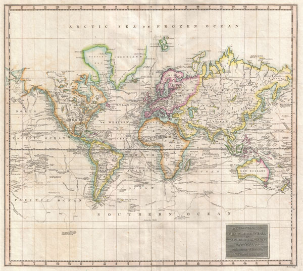
1814 Thomson Map of the World on Mercator's Projection showing Exploratory Routes
WorldMercator-thomson-1814$150.00

Title
Hydrographical Chart of the World on Wright or Mercators Projection With Tracts of the Last Circumnavigators.
1814 (undated) 18 x 20.5 in (45.72 x 52.07 cm)
1814 (undated) 18 x 20.5 in (45.72 x 52.07 cm)
Description
An excellent example of John Thomson's 1814 map of the world on Mercator's projection. Published in the 1814 edition of Thomson's General Atlas, this map was drawn to illustrate the great voyages of discovery of the late 18th century, most specifically Cook, Perouse, and Vancouver. Exploratory routes zigzag through the oceans and seas of this map, showing important land marks on the various voyages illustrated. The map identifies Cook's death in Hawaii, Vancouver's exploration of the Nootka Sound, and Perouse's navigations in Alaska. The routes of Phips around Spitzbergen and Pickersgill in the Baffin Bay are also delineated. The vastly important inland expeditions of Mackenzie (1789) and Hearne (1771) through the interior of North America are also noted. This is the first edition of Thomson's map from the 1814 edition of the General Atlas. Subsequent editions of Thomson's General Atlas were published in 1817 and 1826.
Cartographer
John Thomson (1777 - c. 1841) was a Scottish cartographer, publisher, and bookbinder active in Edinburgh during the early part of the 19th century. Thomson apprenticed under Edinburgh bookbinder Robert Alison. After his apprenticeship, he briefly went into business with Abraham Thomson. Later, the two parted ways, John Thomson segueing into maps and Abraham Thomson taking over the bookbinding portion of the business. Thomson is generally one of the leading publishers in the Edinburgh school of cartography, which flourished from roughly 1800 to 1830. Thomson and his contemporaries (Pinkerton and Cary) redefined European cartography by abandoning typical 18th-century decorative elements such as elaborate title cartouches and fantastic beasts in favor of detail and accuracy. Thomson's principle works include Thomson's New General Atlas, published from 1814 to 1821, the New Classical and Historical Atlas of 1829, and his 1830 Atlas of Scotland. The Atlas of Scotland, a work of groundbreaking detail and dedication, would eventually bankrupt the Thomson firm in 1830, at which time their plates were sequestered by the court. The firm partially recovered in the subsequent year, allowing Thomson to reclaim his printing plates in 1831, but filed again for bankruptcy in 1835, at which time most of his printing plates were sold to A. K. Johnston and Company. There is some suggestion that he continued to work as a bookbinder until 1841. Today, Thomson maps are becoming increasingly rare as they are highly admired for their impressive size, vivid hand coloration, and superb detail. More by this mapmaker...
Source
Thomson, J. A New General Atlas, (Edinburgh) 1814.
Condition
Very good condition. Original centerfold exhibits some verso repair and reinforcement. Blank on verso.