This item has been sold, but you can get on the Waitlist to be notified if another example becomes available.
1893 Rand McNally Map of the Chicago World's Fair or Columbian Exposition
WorldsColumbian-mcnally-1893$100.00

Title
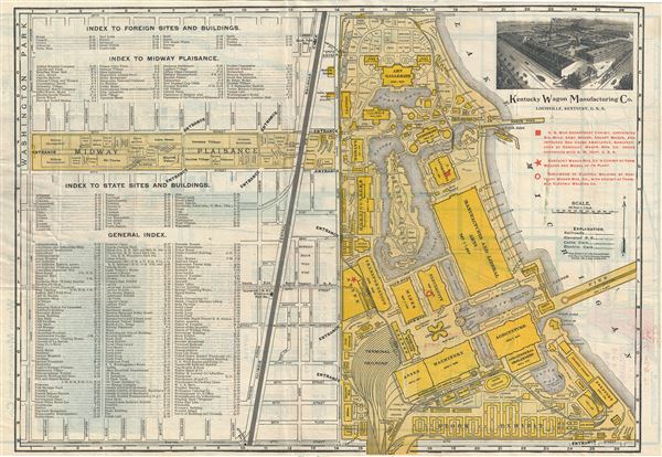
Indexed Guide Map and key to World's Fair Buildings, Grounds and Exhibits.
1893 (dated) 13.5 x 20 in (34.29 x 50.8 cm) 5.041666667
1893 (dated) 13.5 x 20 in (34.29 x 50.8 cm) 5.041666667
Description
This is a scarce map prepared in 1893 by Rand McNally and Co. for the Chicago World's Fair or, as it is better known, the 1893 Columbian Exposition. The map is printed on both sides. The primary side shows the grounds of the Columbian Exposition, now Jackson Park and Field Museum, naming all important buildings, walks, pavilions, markets, etc. Among the specific sites noted is 'Buffalo Bill's Wild West Show and the various pavilions established for manufacturing, mining, liberal arts, electricity, mining, machinery etc., as well as all exhibits and individual buildings. The left half of the map includes a general index, an index to state and foreign sites and buildings and an index to midway Plaisance. Railroad, elevated rail road, cable car and electric car routes are noted.
Verso of the map features a street plan of Chicago from Kinsey Street south as far as 67th St. and west to Canal St., with the World's Fair grounds in red and a small inset of Rand McNally's card map of Chicago. Another index listing railroads, hotels, theaters and streets north of 12th St. is included.
The 1893 Columbian Exposition or Chicago World's Fair was a pivotal moment in the history of the United States. Chicago won the right to host the World's Fair over New York, Washington D.C., and St. Louis. During its six month run, nearly 27,000,000 people attended the fair, which was roughly half the population of the United States at the time. Its numerous displays and exhibits established conventions for architecture, design, and decorative arts, in addition to initiating a new era of American industrial optimism.
The layout and design of the fair, as seen here, is the work of Daniel Burnham and Frederick Law Olmsted, the genius behind New York City's Central Park and Brooklyn's Prospect Park, among others. Most of the fair was designed in the Beaux Arts tradition, a popular movement in Paris that was quickly gaining global momentum. In the years following the fair, this influential architectural style redefined the cityscape of Chicago, Boston, New York, and many other prominent American cities.
Copyrighted 1893 by Rand McNally and Company and based on their New Indexed Standard Guide Map of the World's Columbian Exposition, this map was published and distributed with compliments from the Kentucky Wagon Manufacturing Co., manufacturers of the 'Old Hickory' and 'Tennessee' farm and freight wagons, as an promotional map. The location of their exhibit is noted in red and both sides of the map include large advertisements for the company.
Cartographer
Rand, McNally and Co. (fl. 1856 - present) is an American publisher of maps, atlases and globes. The company was founded in 1856 when William H. Rand, a native of Quincy, Massachusetts, opened a print shop in Chicago. Rand hired the recent Irish immigrant Andrew McNally to assist in the shop giving him a wage of 9 USD per week. The duo landed several important contracts, including the Tribune's (later renamed the Chicago Tribune) printing operation. In 1872, Rand McNally produced its first map, a railroad guide, using a new cost effective printing technique known as wax process engraving. As Chicago developed as a railway hub, the Rand firm, now incorporated as Rand McNally, began producing a wide array of railroad maps and guides. Over time, the firm expanded into atlases, globes, educational material, and general literature. By embracing the wax engraving process, Rand McNally was able to dominate the map and atlas market, pushing more traditional American lithographic publishers like Colton, Johnson, and Mitchell out of business. Eventually Rand McNally opened an annex office in New York City headed by Caleb S. Hammond, whose name is today synonymous with maps and atlases, and who later started his own map company, C. S. Hammond & Co. Both firms remain in business. More by this mapmaker...
Condition
Very good. Printed on both sides. Recto features map of the World's Columbian Exposition. Verso features map of Chicago, but is partially visible under archival tissue. Minor wear along original fold lines. Professionally flattened and backed with archival tissue.