This item has been sold, but you can get on the Waitlist to be notified if another example becomes available, or purchase a digital scan.
1948 Turner Map of the World on a Polar Projection
WorldToDay2nd-turner-1948$162.50

Title
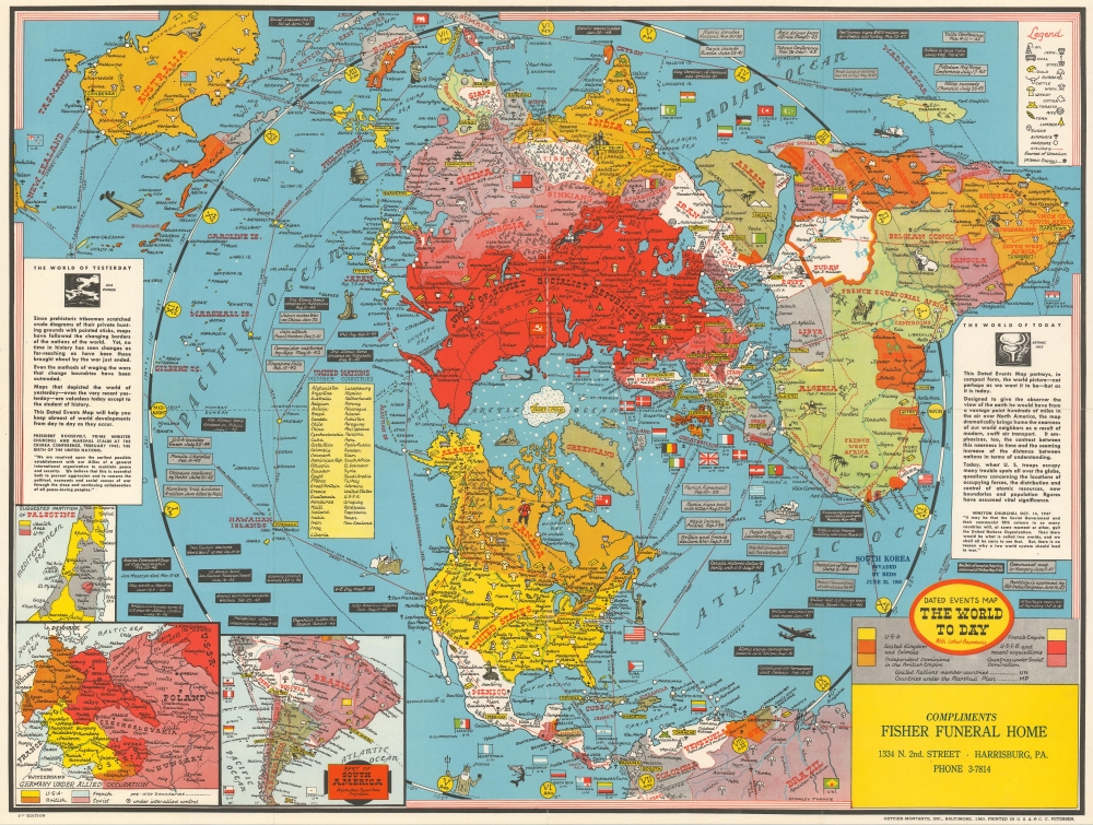
Dated Events Map The World To Day with Latest Boundaries.
1948 (undated) 20 x 26.25 in (50.8 x 66.675 cm)
1948 (undated) 20 x 26.25 in (50.8 x 66.675 cm)
Description
This is a 1948 Stanley Francis Turner map of the world on a polar projection. Completed in Turner's iconic style, the countries of the world are all labeled and many of these countries' flags are illustrated as well. World capitals are highlighted in yellow and myriad other cities throughout the world are also labeled. Africa's geography still represents the era of colonialism, with French Equatorial Africa, French West Africa, the Belgian Congo, Rhodesia, and Tanganyika all labeled. Icons mark natural resources, including oil, coal, iron, steel, and gold, along with corn, wool, lumber, and rubber. Small mushroom clouds mark 'sources of uranium'. Insets in the lower left corner detail central and eastern Europe (including the Allied occupation of Germany), the suggested partition of Palestine (with yellow shaded areas marking proposed Jewish regions), and southern South America (which was cut off by the map's projection).
Dated Events Content
Small text boxes appear all over the map that present short summaries of events from the mid-1930s through 1948. Too many individual events are noted to list them all here, however, some include the date of the 1st atomic bomb test at Los Alamos, Churchill's Fulton, Missouri speech where he coined the phrase 'iron curtain', the D-Day invasion, the atomic bombings of Hiroshima and Nagasaki, the assassination of Mahatma Gandhi, and the declaration of the state of Israel. A yellow-shaded textbox in the Pacific Ocean lists the members countries of the newly-founded United Nations and two other textboxes attempt to summarize 'The World of Yesterday' and 'The World of Today'. In 'The World of Today' text, Turner provides a short summary of this work, 'This Dated Events Map portrays, in compact form, the world picture - not perhaps as we want it to be - but as it is today.'Publication History and Census
This map was drawn by Stanley Francis Turner and published by C.C. Petersen in 1948. Many of Turner's maps were used as advertising materials for businesses across the United States. This example was 'Compliments Fisher Funeral Home' in Harrisburg, Pennsylvania. At least two editions of this map were created by Turner, with this representing the second edition. This map is uncatalogued in OCLC and is scarce on the private market.CartographerS
Stanley Francis Turner (1883 – 1953) was a visual artist and painter based in Toronto, Canada. Turner was born in Aylesbury, England. He studied art in London at the South Kensington School before migrating to Canada in 1903, where he studied at Ontario College of Art under George Reid and J. W. Beatty. Turner is best known as a painter and designer capable of working in a variety of mediums. During World War II, Turner took a contract with the Globe and Mail to illustrate pictorial maps of war events. Turner may have maintained the rights to his war maps, as he also seems to have had a contract with the advertiser and publisher, C.C. Peterson, also of Toronto, to publish and distribute his maps in the United States. Turner's maps are information dense and designed to illustrate the events of the war in an easily digestible pictorial format. Turner experimented with different ways of working with the cartographic ranging from simple Mercator projections to more contemporary equal-area projections. In 1930, Turner was elected an Associate of the Royal Canadian Academy of Arts. He died in Toronto in 1953. More by this mapmaker...
C. C. Peterson (fl. c. 1940 – 1950) was an advertising and publishing company based in Toronto Canada, but with distribution and licensing in both the United States and Canada. Peterson had contracts with the artist Stanley Francis Turner to publish pictorial 'war maps' during World War II. The company supplemented its income by selling advertisements on Turner's maps. Learn More...
Condition
Very good. Even overall toning. Light wear along original fold lines. Accompanied by original mailing envelope.