This item has been sold, but you can get on the Waitlist to be notified if another example becomes available, or purchase a digital scan.
1946 Dickerhoff Infographic Chart of the Pacific Theater during World War II
WorldWarII-dickerhoff-1946$225.00

Title
Factual Chart of World War II Asiatic-Pacific Operations. / World War II - 1941-1945 - Asiatic-P{acific Operations.
1946 (dated) 37.5 x 56 in (95.25 x 142.24 cm)
1946 (dated) 37.5 x 56 in (95.25 x 142.24 cm)
Description
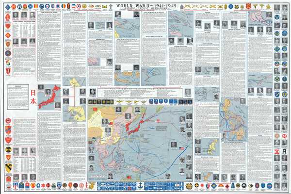
This is a 1946 Samuel Calvin Dickerhoff, Jr. infographic chart of the Asiatic – Pacific Operations during World War II. A meticulously detailed chart, it traces events Asia and the Pacific from before the Japanese attack on Pearl Harbor (which would have been nearly every American's point of reference when it came to the war in the Pacific) to the end of the war. Progressing from left to right in a series of columns, the chart begins by listing in table-form Japanese territorial gains prior to Pearl Harbor, as far back as 1861. Then, Dickerhoff includes a short history of the Japanese imperial dynasty and explanation of the Shinto religion and concludes with a table listing Japanese aggression after Pearl Harbor. Portraits of influential figures in the Japanese government, army, and navy are also included at the top and bottom of this first column.
The rest of the chart deals directly with events that either directly impacted, or occurred during, World War II. Japanese Imperialism, from the Mukden Incident in China in 1931 to December 6th (the day before the attack on Pearl Harbor) are traced. From here, Dickerhoff details each of the main engagements of the Pacific War, chronicling events in chronological order, from the fall of the Philippines and the fall of Singapore to the Battle of the Coral Sea, the Battle of Midway, and the American landings on Guadalcanal. Maps are included along with most of these operations, particularly the 'island hopping' campaigns, which include Tarawa, Eniwetok, and Saipan, Tinian, and Peleliu. Then came the climactic battles of the Pacific War, the liberation of the Philippines (which is discussed in considerable detail, along with the Battle of Leyte Gulf), Iwo Jima, and Okinawa. Specific maps of these battles include the attack on Pearl Harbor, the fall of the Philippines, the fall of Singapore, the Battle of the Coral Sea, the Battle of Midway, the American invasion of the Philippines, and the engagements on Iwo Jima and Okinawa.
A large map of the Pacific is situated along the bottom border, which provides the viewer with a fantastic overview of the incredible distances involved in fighting the Pacific War and also the different 'lines of invasion' used by both the American and the Japanese. The most intriguing part of this map, however, and perhaps the most intriguing aspect of the entire chart, is present on this map. Both Operation Olympic and Operation Coronet, the planned invasions of the Japanese home islands, are illustrated. The units involved in these operations are also noted, allowing for some understanding of just how many men were to be involved in such a massive undertaking. If this operation had taken place, both sides would have suffered an incredible number of casualties and the fighting would have been unimaginably brutal. As it stood, American air and sea power were devastating the Japanese home islands, fire-bombing cities from the air and using the navy's ship-mounted guns to barrage coastlines. It is interesting to note that Dickerhoff states in the section titled 'The End' that 'Japan was defeated before the atomic bomb or Russia's entry into the war.' This debate, whether or not the atomic bombs should have been dropped on Hiroshima and Nagasaki, will continue as long as humanity has an interest in its own history, and there will never be a consensus on which decision was the correct one.
The central informational portion is framed by the insignia of all the units that participated in the Pacific War on the top, bottom and left side, while portraits of most of the high ranking commanding officers are included along the right border.
This chart was compiled by Samuel Calvin Dickerhoff, Jr. and Paul Yoklisch and printed by the World War Chart Company. Dickerhoff also issued a similar but earlier and far rarer chart illustrating World War I.
CartographerS
Samuel Calvin Dickerhoff, Jr. (November 19, 1894 - September 5, 1974) was an American businessman and research engineer. Born in Williamsport, Maryland to Samuel C. and Emma Richter Dickerhoff, he attended Purdue University and was a member of the Sigma Alpha Epsilon Fraternity. He was affiliated with the Bethlehem Steel Corporation and then started the Automatic Nut Company in 1939. He operated this enterprise until 1962, when he sold it to Bethlehem Steel. As a research engineer, he developed and published a Steel Chart showing the operations of producing steel. He also created and published charts on the history of World War I and World War II. He married Catherine Cushwa, who survived him. More by this mapmaker...
Paul Yoklisch (1904 - 1952) was born in Pennsylvania and married mary Mavretic in 1931. He is credited as one of the creators of the Factual Chart of World War II Asiatic- Pacific Operations. His son, Robert Yoklisch, served with the U.S. Army in Korea in 1955. Learn More...
Condition
Very good. Wear along original fold lines. Accompanied by original portfolio. Blank on verso.
References
Rumsey 12192.000. OCLC 32226944.