This item has been sold, but you can get on the Waitlist to be notified if another example becomes available, or purchase a digital scan.
1917 Rand McNally Wyoming Pocket Map
Wyoming-randmcnally-1917$100.00

Title
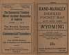
Rand-McNally Indexed Pocket Map and Auto Road Guide, Wyoming.
1917 (undated) 20.75 x 28 in (52.705 x 71.12 cm) 1 : 982080
1917 (undated) 20.75 x 28 in (52.705 x 71.12 cm) 1 : 982080
Description
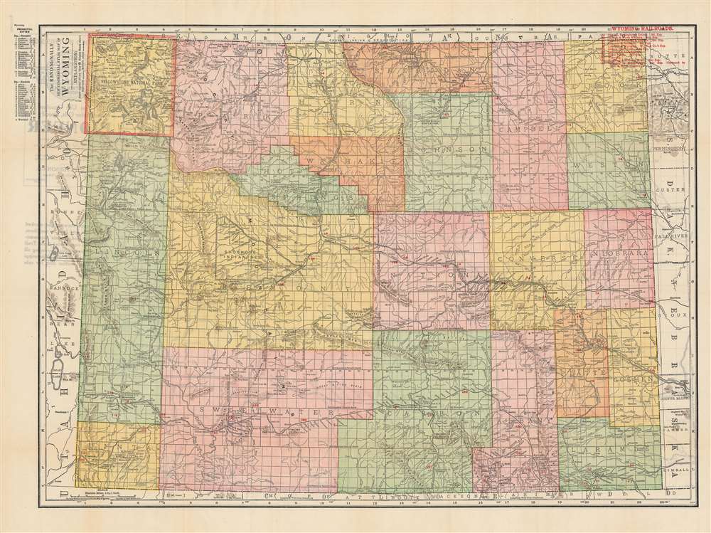
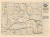
This is a c. 1917 Rand-McNally pocket map of Wyoming. It shows the state’s administrative divisions, infrastructure, and geographic features along with a grid, index, and accompanying auto map on the verso (back).
As the population figures indicate, Wyoming was sparsely populated. Still, the suitability of land for grazing livestock could lead to disputes, as with the Johnson County War of 1892. Other forms of frontier violence also occurred, most notoriously the Rock Springs Massacre of 1885 that targeted Chinese miners.
The territory noted here as ‘Shoshone Indian Res.’ is today the Wind River Indian Reservation, home to both Eastern Shoshone and Northern Arapaho peoples, though its true extent is larger than appears here, stretching into Hot Springs County near Thermopolis. The Arapaho had earlier resided further south and east but were chased out of their ancestral homeland in the Pike’s Peak Gold Rush and the Colorado War of 1864-1865. The U.S. Army resettled them at Ft. Washakie until a permanent reservation location could be agreed, but such an agreement never came, causing a dispute with the Shoshone who had already been guaranteed the surrounding territory. Some twenty years after this map’s publication, the U.S. Supreme Court acknowledged the violation of the agreement with the Shoshone, after which a land deal between the Shoshone and Arapaho was agreed and the reservation renamed to its current title. Having thus been pushed together, the two tribes have maintained a complicated relationship, with cultural and social ties growing but with both wanting to maintain a degree of sovereignty and autonomy.
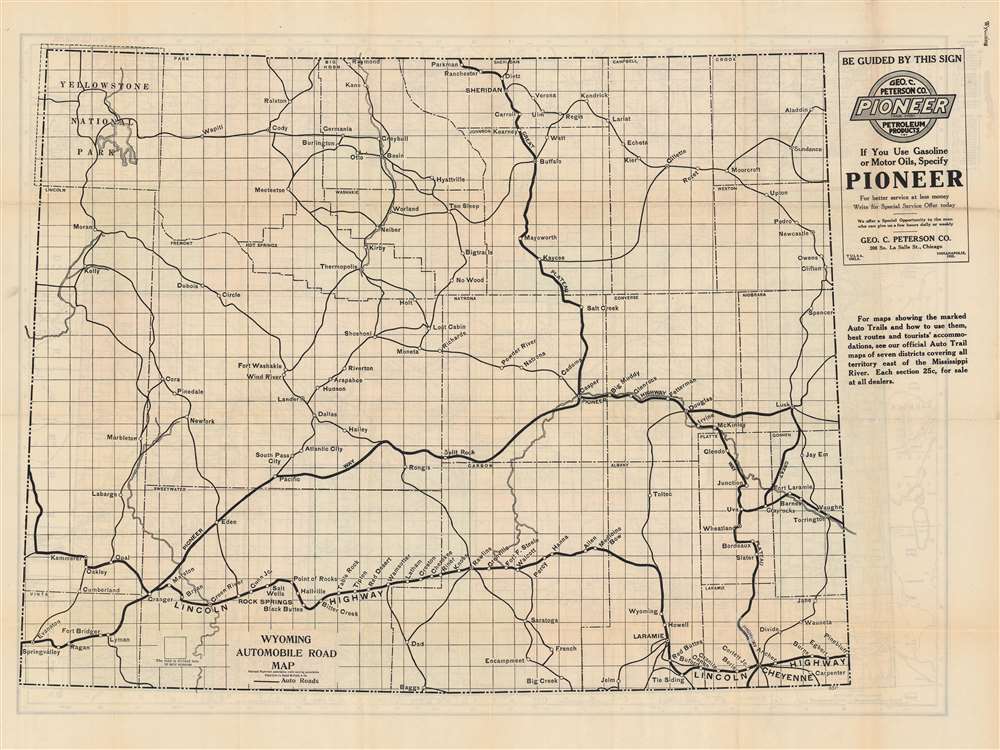
Aside from the colorful map on the front, an automobile road map appears on the verso. The Lincoln Highway route shown here as connecting Cheyenne and Laramie to Rock Springs and beyond is largely followed today by Interstate 80. Although railroads reached Yellowstone National Park in the 1880s, by the time this map was published increasing numbers of visitors used automobiles, which caused problems for the previous mode of transport within the park, horse-drawn carriages.
A Closer Look
The map covers the state of Wyoming identifying counties, rivers, topography, and railroads, which are listed in red text at upper-right. Cities and towns are listed at top-left according to their population and are given a coordinate corresponding to the numbered and lettered grid system in the margins.As the population figures indicate, Wyoming was sparsely populated. Still, the suitability of land for grazing livestock could lead to disputes, as with the Johnson County War of 1892. Other forms of frontier violence also occurred, most notoriously the Rock Springs Massacre of 1885 that targeted Chinese miners.
The territory noted here as ‘Shoshone Indian Res.’ is today the Wind River Indian Reservation, home to both Eastern Shoshone and Northern Arapaho peoples, though its true extent is larger than appears here, stretching into Hot Springs County near Thermopolis. The Arapaho had earlier resided further south and east but were chased out of their ancestral homeland in the Pike’s Peak Gold Rush and the Colorado War of 1864-1865. The U.S. Army resettled them at Ft. Washakie until a permanent reservation location could be agreed, but such an agreement never came, causing a dispute with the Shoshone who had already been guaranteed the surrounding territory. Some twenty years after this map’s publication, the U.S. Supreme Court acknowledged the violation of the agreement with the Shoshone, after which a land deal between the Shoshone and Arapaho was agreed and the reservation renamed to its current title. Having thus been pushed together, the two tribes have maintained a complicated relationship, with cultural and social ties growing but with both wanting to maintain a degree of sovereignty and autonomy.
Aside from the colorful map on the front, an automobile road map appears on the verso. The Lincoln Highway route shown here as connecting Cheyenne and Laramie to Rock Springs and beyond is largely followed today by Interstate 80. Although railroads reached Yellowstone National Park in the 1880s, by the time this map was published increasing numbers of visitors used automobiles, which caused problems for the previous mode of transport within the park, horse-drawn carriages.
Publication History and Census
This is a separate issue edition of Rand-McNally’s Commercial Atlas map of Wyoming, with the addition of the road map on the verso. The date is uncertain, but it most closely resembles the Commercial Atlas map of Wyoming issued in the 1910s. The use of the phrase ‘Indexed Pocket Map and Auto Road Guide’ in the title corresponds to Rand McNally pocket maps of other states dated to the late 1910s, while the inclusion of the Lincoln Highway on the verso suggests that it was published no later than 1926. This edition of the map is not known to exist in any institution’s holdings and is very scarce to the market.Cartographer
Rand, McNally and Co. (fl. 1856 - present) is an American publisher of maps, atlases and globes. The company was founded in 1856 when William H. Rand, a native of Quincy, Massachusetts, opened a print shop in Chicago. Rand hired the recent Irish immigrant Andrew McNally to assist in the shop giving him a wage of 9 USD per week. The duo landed several important contracts, including the Tribune's (later renamed the Chicago Tribune) printing operation. In 1872, Rand McNally produced its first map, a railroad guide, using a new cost effective printing technique known as wax process engraving. As Chicago developed as a railway hub, the Rand firm, now incorporated as Rand McNally, began producing a wide array of railroad maps and guides. Over time, the firm expanded into atlases, globes, educational material, and general literature. By embracing the wax engraving process, Rand McNally was able to dominate the map and atlas market, pushing more traditional American lithographic publishers like Colton, Johnson, and Mitchell out of business. Eventually Rand McNally opened an annex office in New York City headed by Caleb S. Hammond, whose name is today synonymous with maps and atlases, and who later started his own map company, C. S. Hammond & Co. Both firms remain in business. More by this mapmaker...
Condition
Very good.