This item has been sold, but you can get on the Waitlist to be notified if another example becomes available, or purchase a digital scan.
1886 Rand McNally Railroad Map of Wyoming and Nebraska
WyomingNebraska-randmcnally-1886$625.00


Title
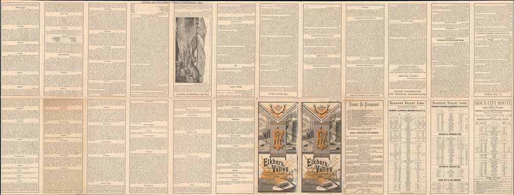
Fremont, Elkhorn and Missouri Valley R.R. and Connections, to the Free Homes for theMillion in Northwestern Nebraska and Southwestern Dakota. / The Elkhorn Valley Line to Northern Nebraska, Central Wyoming and The black Hills.
1886 (dated) 17.75 x 46.75 in (45.085 x 118.745 cm) 1 : 1140480
1886 (dated) 17.75 x 46.75 in (45.085 x 118.745 cm) 1 : 1140480
Description
This is an impressive and highly detailed 1886 Rand McNally map of Wyoming, Dakota, and Nebraska issued to promoted migration to free 'government lands' in the west. It also illustrates the route of the important Fremont, Elkhorn and Missouri Valley Railroad.
A Closer Look
Coverage extends from Yellowstone National Park (founded 1872) to Omaha, Nebraska. Although the map's focus is on the railroad line, the map is surprisingly detailed throughout, naming land agencies, mining districts, 'springs of petroleum', showing topography, and naming ranches. This striking detail stems from the maps secondary purpose, to propagandize emigration to free government lands in the west. Rich textual content on the verso explains the grant system, requirements, and processes, as well as promotes the virtue of the land and climate.Fremont, Elkhorn and Missouri Valley Railroad
'The Elkhorn', as it was colloquially known, was a Nebraska railroad founded in 1869. The railroad initially centered around a line between Omaha ad Chadron - known as the 'Cowboy Line'. It began a series of expansions through the 1880s to reach the Black Hills, Rapid City (South Dakota), Belle Fourche (South Dakota), and Caspar (Wyoming). The railroad's founders recognized the fortunes to be made transporting emigrants to the vast acreage of free government lands in Nebraska, Wyoming, and Dakota. Every man who wanted it, was entitled to 160 acres of prime farmland - a nigh irresistible offer to the eastern poor. In the late 19th century, the Chicago and North Western Railway acquired The Elkhorn, merging it fully into their system by 1903. Today most of the lines are abandoned, but segments are operated as heritage railways.Publication History and Census
This 1886 map was printed in Chicago by Rand McNally for the Fremont, Elkhorn, and Missouri Valley Railroad. Cartographically it is based upon a combination of U.S. Land Office maps and private railroad surveys. We are aware of only one other surviving example - that being located at Yale. The Yale example has different verso text, but the map is identical, suggesting multiple states.Cartographer
Rand, McNally and Co. (fl. 1856 - present) is an American publisher of maps, atlases and globes. The company was founded in 1856 when William H. Rand, a native of Quincy, Massachusetts, opened a print shop in Chicago. Rand hired the recent Irish immigrant Andrew McNally to assist in the shop giving him a wage of 9 USD per week. The duo landed several important contracts, including the Tribune's (later renamed the Chicago Tribune) printing operation. In 1872, Rand McNally produced its first map, a railroad guide, using a new cost effective printing technique known as wax process engraving. As Chicago developed as a railway hub, the Rand firm, now incorporated as Rand McNally, began producing a wide array of railroad maps and guides. Over time, the firm expanded into atlases, globes, educational material, and general literature. By embracing the wax engraving process, Rand McNally was able to dominate the map and atlas market, pushing more traditional American lithographic publishers like Colton, Johnson, and Mitchell out of business. Eventually Rand McNally opened an annex office in New York City headed by Caleb S. Hammond, whose name is today synonymous with maps and atlases, and who later started his own map company, C. S. Hammond & Co. Both firms remain in business. More by this mapmaker...
Condition
Very good. A few minor verso reinforcements and repairs on original fold lines. Right margin trimmed to neatline at time of publication.
References
Yale University Library, Zc35 886th.