This item has been sold, but you can get on the Waitlist to be notified if another example becomes available, or purchase a digital scan.
1878 Hayden Panoramas of Wind River and Teton Ranges, Wyoming
WyomingPanoramas-hayden-1878$300.00


Title
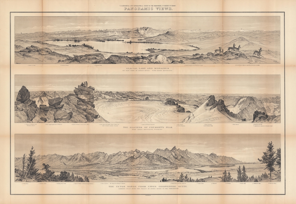
Panoramic views : Glacial lake and moraines on New Fork of Green River - Wind River Mountains ; the glaciers of Fremont's Peak, Wind River Mountains, Wyoming ; the Teton Range from upper Grosventre Butte looking west, with the valley of Snake River in the foreground.
1878 (undated) 26.25 x 35.5 in (66.675 x 90.17 cm)
1878 (undated) 26.25 x 35.5 in (66.675 x 90.17 cm)
Description
A stunning set of views drawn by William Henry Holmes, produced in 1878 by Ferdinand Vandeveer Hayden and the U.S. Geological and Geographical Survey of the Territories (USGGST), the forerunner to the U.S. Geological Survey. They display panoramas of portions of the Wind River and Teton Ranges in Wyoming.
A Closer Look
The sheet is divided into three panoramic views, which are: Glacial Lake and Moraines on New Fork of Green River, Wind River Mountains; The Glaciers of Frémont's Peak, Wind River Mountains, Wyoming; and The Teton Range from Upper Grosventre Butte Looking West, with the Valley of Snake River in the Foreground. Captions beneath each view correspond to notation relating to specific locations, geological features, and elevation. Members of the survey are illustrated atop Fremont's Peak at left in the second view, while a small herd of deer run at right in the top view.The U.S. Geological and Geographical Survey of the Territories
The U.S. Geological and Geographical Survey of the Territories (also known as the Hayden Survey) was created under the U.S. Department of the Interior in 1870, with Hayden as its director. It operated through 1879. The first year the Survey operated in Wyoming on a budget of $25,000 with twelve assistants and eight teamsters and cooks. The following year (1871), the Survey received $40,000 and employed thirty-two individuals, including artist Thomas Moran and photographer W. H. Jackson. That year they launched from Ogden, Utah (which the Union Pacific Railroad had reached) and spent the summer in what is now Yellowstone National Park. The work conducted by the survey that year played a critical role in convincing the U.S. Senate to create Yellowstone, the first U.S. National Park. The Survey worked in Colorado from 1873 through 1876 because of hostilities between white settlers and Native Americans in Wyoming. The team returned to the Yellowstone in 1877 and 1878. Then, in 1879, the Hayden Survey, along with surveys led by John Wesley Powell (the Colorado River and the Grand Canyon) and Clarence King (Fortieth Parallel Survey), were merged to create the U.S. Geological Survey.Publication History and Census
These views were drawn by William Henry Holmes, produced by the USGGST, led by Ferdinand Vandeveer Hayden, and photolithographed by Julius Bien and Company. Though originally drawn earlier, the sheet is usually dated to 1878 as it appeared in the Twelfth Annual Report of the USGGST for the year 1878 (it is also sometimes dated to 1883 as the 1878 report was not published by the Government Printing Office until 1883). It should not be confused with an 1881 set of views with the same title published in the Geological and Geographical Atlas of Colorado and portions of adjacent territory, also produced by the USGGST. Due to these discrepancies over publication date, as well as cataloging variations in the title and attribution of authorship, and the co-mingling of digital and physical copies, these views appear in multiple listings in the OCLC. All told, this sheet is independently cataloged among the holdings of eight institutions worldwide, while the entire 1878 Annual Report is more widely distributed.CartographerS
William Henry Holmes (December 1, 1846 - April 20, 1933) was an American geologist, cartographer, artist, explorer, archaeologist, scientific illustrator, anthropologist, museum curator, and mountain climber. Born on a farm near Cadiz, Ohio, and, in 1870, graduated from the McNeely Normal School in Hopedale, Ohio. Holmes briefly taught painting, drawing, geology, and natural history at the school before moving to Washington, D.C. to study art under Theodore Kaufmann in 1871. Holmes's talent for art soon garnered the attention of scientists at the Smithsonian Institution, who employed him to draw and sketch fossil shells and the shells of live mollusks. Holmes replaced Thomas Moran as the artist/topographer of the government survey of Ferdinand Vandeveer Hayden in 1872 and made his first expedition west to Yellowstone National Park. He earned a national reputation as a scientific illustrator during the 1870s and helped Hayden produce the Geological and Geographical Atlas of Colorado, And Portions of Adjacent Territory, published in 1877 and 1881. The Hayden Survey was absorbed by the U.S. Geological Survey in 1879, which allowed Holmes to leave for Munich, Germany, to further his art education under Frank Duveneck. While in Germany, he also studied 'museum making' at Dresden's Anthropology Museum under Adolphe B. Meyer. Holmes 'returned' to the U.S. Geological Survey upon his return to the United States and worked as a geologist and illustrator. In 1889 Holmes left the Geological Survey to join the Smithsonian Institution's Bureau of American Ethnology as an archaeologist. Then he worked as the curator of anthropology at the Field Columbian Museum in Chicago, Illinois from 1894 through 1897. In 1897 Holmes returned to Washington, D.C. to serve as the U.S. National Museum's head curator of anthropology. He served as chief of the Bureau of American Ethnology from 1902 through 1905 and then became the chairman of the U.S. National Museum's Division of Anthropology in 1910. He became the director of the National Gallery of Art (now the Smithsonian American Art Museum) in 1920. He retired from his position as Director of the National Gallery of Art in 1932 and moved to Royal Oak, Michigan, to live with his son. More by this mapmaker...
Ferdinand Vandeveer Hayden (September 7, 1829 - December 22, 1887) was an American geologist remembered for leading late 19th century pioneering surveying expedition in the Rocky Mountains and served as a doctor in the Union Army during the U.S. Civil War. Born in Westfield, Massachusetts, and discovered a fascination with nature and wildlife in his youth. He studied at Oberlin College and graduated in 1850, then attended the Albany Medical College and earned his degree in 1853. While at Albany, Hayden garnered the attention of Professor James Hall, then the state geologist of New York. Professor Hall convinced Hayden to join an expedition to the Nebraska Territory, where he collected fossils and studied geology. He accompanied expeditions led by Gouverneur K. Warren in 1856 and 1857 and the Raynolds Expedition of 1860 led by Captain William F. Raynolds. He served as an army surgeon during the U.S. Civil War and rose to become the chief medical officer of the Army of the Shenandoah. After the war, Hayden resumed working on geologic and geographic surveys in the Nebraska and Western Territories and was appointed geologist-in-chief of the United States Geological and Geographical Survey of the Territories in 1867. Hayden led the first federally funded geological survey into the Yellowstone Region in northwestern Wyoming in 1871 under orders from Secretary of the Interior Columbus Delano. The expedition included fifty men, including painter Thomas Moran and Civil War photographer William Henry Jackson. Hayden's report on the expedition, Preliminary Report of the United State Geological Survey of Montana and Portions of Adjacent Territories; Being a Fifth Annual Report of Progress played an instrumental role in persuading Congress to establish Yellowstone as the first U.S. National Park. Learn More...
Julius (Julien) Bien (September 27, 1826 - December 21, 1909) was a German-Jewish lithographer and engraver based in New York City. Bien was born in Naumburg, Germany. He was educated at the Academy of Fine Arts, Cassell and at Städel's Institute, Frankfurt-am-Main. Following the suppression of the anti-autocratic German Revolutions of 1848, Bien, who participated in the pan-German movement, found himself out of favor in his home country and joined the mass German immigration to the United States. Bien can be found in New York as early as 1849. He established the New York Lithographing, Engraving & Printing Company in New York that focused on the emergent chromo-lithograph process - a method of printing color using lithographic plates. His work drew the attention of the U.S. Government Printing Office which contracted him to produce countless government maps and surveys, including the Pacific Railroad Surveys, the census, numerous coast surveys, and various maps relating to the American Civil War. Bien also issued several atlases both privately and in conjunction with a relation, Joseph Bien. At the height of his career Bien was elected president of the American Lithographers Association. After his death in 1909, Bien's firm was taken over by his son who promptly ran it into insolvency. The firm was sold to Sheldon Franklin, who, as part of the deal, retained the right to publish under the Julius Bien imprint. In addition to his work as a printer, Bien was active in the New York German Jewish community. He was director of the New York Hebrew Technical Institute, the New York Hebrew Orphan Asylum, and president of the B'nai B'rith Order. Learn More...
Source
Hayden, F. V., Twelfth Annual Report of the United States Geological and Geographical Survey of the Territories: A report of progress of the exploration in Wyoming and Idaho for the year 1878, (Washington, D.C.: Government Printing Office) 1883.
Condition
Good. Verso repairs at fold lines. Light toning on fold lines. Two very small areas of infill at intersections.
References
Rumsey 5939.000. OCLC 367574836.