This item has been sold, but you can get on the Waitlist to be notified if another example becomes available, or purchase a digital scan.
1930 Auto Club Map of Yellowstone and Grand Tetons N.P. Wyoming
YellowstoneGrandTetons-autoclubsocal-1930$125.00


Title
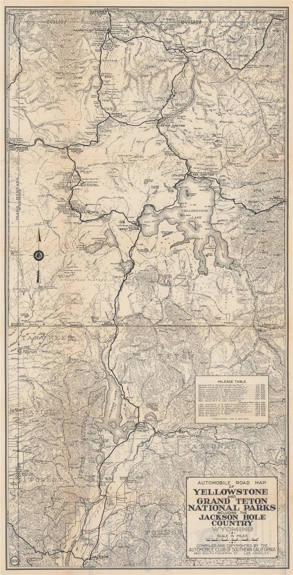
Automobile Road Map of Yellowstone and Grand Teton National Parks Including the Jackson Hole Country Wyoming.
1930 (undated) 26 x 13.25 in (66.04 x 33.655 cm) 1 : 270000
1930 (undated) 26 x 13.25 in (66.04 x 33.655 cm) 1 : 270000
Description
This is a c. 1930 Automobile Club of Southern California road map of Yellowstone and Grand Teton National Parks. Famous landmarks throughout are identified, including Old Faithful, Mammoth Hot Springs, and Yellowstone and Jackson Lakes. Ranger stations, lodges, hotels, campsites, rivers, lakes, mudkettles, mudpots, hot springs, and other features of both parks are included.
Yellowstone National Park
Yellowstone National Park, established by the U.S. Congress and signed into law by President Ulysses S. Grant on March 1, 1872, is the United States' first and most famous national park. The park occupies the northwestern corner of Wyoming but also includes parts of Montana and Idaho. Yellowstone is considered to be the world's first national park. Today a UNESCO World Heritage Site, the park is known for its incredible geothermal features, the most famous of which is the Old Faithful Geyser. Yellowstone's iconic geothermal activity is caused by a dormant supervolcano, the largest in North America, lying directly under the park. Yellowstone Lake, one of the largest high-elevation lakes on the continent, occupies the caldera's center. Yellowstone is also renowned for its wildlife, home to wolves, grizzly bear, elk, black bear, and America's largest wild bison herd. As one of the most popular National Parks in the United States, millions visit Yellowstone annually to experience its mud pots, geysers, wildlife, and striking scenery.Publication History and Census
This map was drawn by Selwyn Douglas and published by the Automobile Club of Southern California c. 1930. We note three examples cataloged in OCLC which are part of the collections at Yale University, the Yellowstone Research Library in Gardiner, Montana, and Brigham Young University.Cartographer
The Automobile Club of Southern California (1900 - Present) is an auto club based in Los Angeles, California and an affiliate of the American Automobile Association (AAA). Founded in 1900, it was one of the first auto clubs in the United States and was dedicated to proposing traffic laws, improving road conditions, and the overall improvement of driving conditions. The Auto Club began producing its own maps in 1910, when it sent out its own team of cartographers to survey the state's roads. Its main office at the corner of Figueroa Street and Adams Boulevard was completed in 1923. Numbering nearly 8 million members in its home territory alone, today it is the largest single member of the AAA federation More by this mapmaker...
Condition
Very good. Light wear along original fold lines. Small areas of infill to two fold intersections. Printing on verso.
References
OCLC 56093029.