1936 Jolly Lindgren Pictorial Map of Yellowstone Park and Jackson Hole (Silkscreened)
YellowstoneParkJacksonHoleSP-lindgren-1936$1,200.00

Title
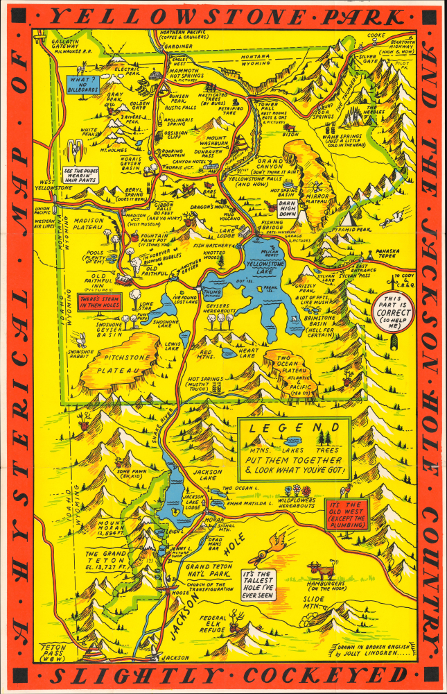
A Hysterical Map of Yellowstone Park and the Jackson Hole Country. Slightly Cockeyed.
1936 (undated) 21.5 x 13.75 in (54.61 x 34.925 cm)
1936 (undated) 21.5 x 13.75 in (54.61 x 34.925 cm)
Description
This is a hilarious c. 1936 Jolly Lindgren pictorial map of Yellowstone National Park and Jackson Hole, Wyoming - here in a hand-silkscreened exemplar. This is the second of two Yellowstone maps issued in 1936; this one is expanded to include Jackson Hole. It also stands out for its deviant red border instead of Lindgren's standard blue. Unlike most Lindgren Brothers maps, this map has no copyright or imprint.
They emerged in the Interwar Period (1918 - 1939), an era defined by the breakdown of social structure, widespread disillusionment, the Great Depression, industrialization, and breakneck technological advances. In the United States, spurred by the ease of movement brought about by the automobile, infrastructure investment by New Deal programs, escapism into nature, and affordability, a nationwide love affair with our national parks emerged and remains to this day.
The Lindgrens capitalized on this unique situation to introduce an affordable, mailable souvenir - the Hysterical Map. Both visually striking and funny, the Hysterical Map could be framed and displayed as a happy memento or folded and mailed to friends and family. The Lindgrens made maps of most of the Great National Parks, as well as other points of interest, though they kept a broad focus on the Western United States. Hysterical Maps remained in production until about 1954.
We invite readers to read our evolving cartobibliography of Lindgren Brothers maps here: Hysterical Maps of the Lindgren Brothers: A Cartobibliography
A Closer Look
Coverage embraces the Yellowstone National Park - Jackson Hole region, from Idaho to the Absaroka Range and from Montana to Jackson. Major roadways are marked in red with important locations, topography, and more illustrated pictorially. Humorous asides and illustrations are present throughout. Some of the amusing annotations include:- Old Faithful singing 'I'm Forever Blowing Bubbles'
- Fountain Paint Pot (It Stinks Too)
- Yellowstone Falls (And How)
- Wahb Springs (Just a Little Cold in the Head)
- Hamburgers (on the Hoof)
- Hot Springs (Mustn't Touch)
Lindgren - Silkscreened or Not?
In any list or collection of Lindgren Brothers Hysterical Maps, it is essential to distinguish between those that were silkscreened by hand and those that were machine printed. Often, the difference is clear even to the untrained eye; other times, it is less so - generally, when not visually clear, you can feel the 'texture' of the layered paint. Likewise, defining an 'edition' is difficult and, in some cases, impossible. The most popular Hysterical Maps, such as Yellowstone, were printed in both silkscreen and machine presses, as well as in a variety of color configurations. Likely, the 1936 issues, to follow through with our Yellowstone example, continued to be issued well after that date using a variety of printing techniques due to their extreme popularity. Even within the narrow limits of those Lindgren maps that were silkscreened, we can trace an evolution of the printing techniques as the Lindgren Brothers refined their silkscreening processes and gained access to higher-quality paints, screens, and papers. Nor is it clear that they ever fully gave up on silkscreening; some of their later maps may have been silkscreened as proofs in the initial phase of production and then transitioned to mechanical printing. Other maps give no evidence of having ever been silkscreened, though it is not unlikely that silkscreened proofs or early examples may yet emerge. For collectors interested in adding value to their collections, silkscreened examples must be considered to be of the highest rarity and the gold standard, thus receiving a correspondingly higher market consideration.Lindgren Brothers Hysterical Maps
Starting in 1932, the Lindgren Brothers of Spokane, Washington, began issuing medium-format pictorial maps, mostly of national parks, which they dubbed 'Hysterical.' The maps were undoubtedly influenced by the comparable work of American mapmakers Jo Mora and Harrison Godwin, as well as international figures such as MacDonald Gill. Lindgren maps were simply illustrated with primary colors and lighthearted content, meant to get a laugh or at least a raised eyebrow.They emerged in the Interwar Period (1918 - 1939), an era defined by the breakdown of social structure, widespread disillusionment, the Great Depression, industrialization, and breakneck technological advances. In the United States, spurred by the ease of movement brought about by the automobile, infrastructure investment by New Deal programs, escapism into nature, and affordability, a nationwide love affair with our national parks emerged and remains to this day.
The Lindgrens capitalized on this unique situation to introduce an affordable, mailable souvenir - the Hysterical Map. Both visually striking and funny, the Hysterical Map could be framed and displayed as a happy memento or folded and mailed to friends and family. The Lindgrens made maps of most of the Great National Parks, as well as other points of interest, though they kept a broad focus on the Western United States. Hysterical Maps remained in production until about 1954.
Publication History
This map was part of a series of maps drawn by Jolly Elmer Lindgren. Called 'Hysterical Maps' to differentiate their style and intention from the more common 'historical maps,' there are sister maps of many national parks as well as some universities. This was one of the Lindgren Brothers' earliest and most popular maps. The present example was printed via a silkscreen process, conforming to their earliest maps and proofs. The present silkscreened edition stands out as an exemplar and is priced accordingly.We invite readers to read our evolving cartobibliography of Lindgren Brothers maps here: Hysterical Maps of the Lindgren Brothers: A Cartobibliography
Cartographer
Lindgren Brothers (1928 – 1971) was a Spokane, Washington, based printer known for issuing humorous souvenir auto decals, maps, and posters. The firm was founded as a sign-painting company by Hjalmer 'Jolly' Lindgren (1895 - September 1952) and his brother Oscar 'Ott' Lindgren (1893 - 1967), born in Wisconsin to Swedish immigrants. Neither brother had middle names when they went off to fight in World War I (1914 - 1818), but as the government required it, they adopted Jolly and Ott, which stuck with them for life. Jolly was in charge of the art department and Ott was in charge of the business aspects of the firm. The company began as printers and sign makers, and also became innovators in silkscreen printing, and as the Great Depression deepened, Jolly began producing 'hysterical maps'. He declared at the time, ‘What this country needs now is something to put a smile on people's faces.' The maps are graphically interesting and intended, as the titles suggest, to amuse. The brothers focused on producing maps of popular tourist attractions, and the great national parks of the West were an obvious choice. They produced maps of Yellowstone, the Grand Canyon, Glacier, Zion, Bryce Canyon and others through the early 1940s. Following a hiatus during World War II (1939 - 1945), the company began producing car decals, some of which were simplified versions of the ‘hysterical maps'. The company sold more than ten million decals in a good year. In 1949, the company was renamed the Lindgren-Turner Company when their traveling salesman, Theodore 'Ted' Turner, Jr. (1902 - 1989), who had been with the firm since 1930, became a partner. Jolly died unexpectedly at 57 while visiting his daughter in Boise, Idaho. The firm continued under his brother, Oscar. William Shigeo Terao (1915 - 1990), who was hired after World War II by the Lindgrens and eventually became the firm's art director, created two more hysterical maps following Jolly's death. The company's last great success, after the decal market had become too competitive, was a sign that read 'No Trespassing, Survivors will be Prosecuted'. The signs became a massive success, eventually being sold in every Woolworth's department store nationwide - all 2,228 locations. Ott died in 1967 at the age of 74, leaving Turner as the last member of the original team. He, in turn, sold the firm to the Emblem Manufacturing Company based in Los Angeles, in February 1971 and he and his wife moved to New Mexico three years later to be closer to their daughter. Turner wrote a history of the Lindgren-Turner Company during his retirement and died at the age of 87 in 1989. More by this mapmaker...
Condition
Excellent. Previously Folded. Silkscreen Printed.
References
Rumsey 8070.000. OCLC 953572048; 1065956227.