This item has been sold, but you can get on the Waitlist to be notified if another example becomes available, or purchase a digital scan.
1868 Keio 4 Morookaya Ihei Edo Period Map of Yokohama, Japan
Yokohama-morookayaihei-1868$1,750.00

Title
Yokohama Map. / 橫濱明細全圖.
1868 (dated) 28 x 58 in (71.12 x 147.32 cm) 1 : 2000
1868 (dated) 28 x 58 in (71.12 x 147.32 cm) 1 : 2000
Description
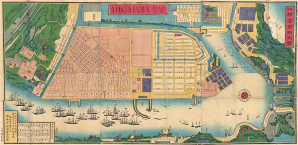
This is an extremely rare large format Yokohama-e style (ukiyo-e) map of Yokohama, Japan, issued in 1868 (Keiō 4) published by Morookaya Ihei (師岡屋伊兵衛). The map is oriented the southwest with north in at the bottom right. It features a variety of perspectives including center weighted Uki-e surround imagery and a strict cadastral survey for the main city grid. Foreign trade vessels ply the seas in the foreground.
Yokohama opened to foreign trade in 1859 and by the time this map was issued had become a bustling international port. The map identifies American, Dutch, English, French, Italian, Prussian, Swiss and Japanese offices. In the waters ships from a multitude of countries are noted – even a steam ship billowing smoke. Although most of the content is in Japanese, the main title appears in English and city blocks are identified numerically in both western and Chinese numbers. The city itself is an island, surrounded on all sides by water and verdant parklands –much of which appears to be slowing giving way to more industrial development. This is the second edition of the map, the first was issued in 1864 (Keiō 1). We have not been able to positively identify another example of this map.
Yokohama opened to foreign trade in 1859 and by the time this map was issued had become a bustling international port. The map identifies American, Dutch, English, French, Italian, Prussian, Swiss and Japanese offices. In the waters ships from a multitude of countries are noted – even a steam ship billowing smoke. Although most of the content is in Japanese, the main title appears in English and city blocks are identified numerically in both western and Chinese numbers. The city itself is an island, surrounded on all sides by water and verdant parklands –much of which appears to be slowing giving way to more industrial development. This is the second edition of the map, the first was issued in 1864 (Keiō 1). We have not been able to positively identify another example of this map.
Cartographer
Morookaya Ihei (師岡屋伊兵衛) (fl. c. 1850 – c. 1880) was a Japanese publisher, painter, printmaker, and print seller specializing in Yokohama-e ukiyo-e Japanese woodblock prints and maps active in Yokohama during the late Edo and early Meiji Era. The firm was based at 5 Chome Bentendori, Yokohama. More by this mapmaker...
Condition
Good. Backed on Japanese tissue. Some repaired loss along original folds intersections.
References
Beans, George H.,A List of Japanese Maps of the Tokugawa Era, 1864.4. Kurita Mototsugu, ed., Nihon kohan chizu shusei (Early maps and plans printed in japan) (Tokyo: Hakata Seishodo, 1928), page 95.