1948 Lindgren Pictorial Map of Yosemite National Park
Yosemite-lindgren-1948$950.00

Title
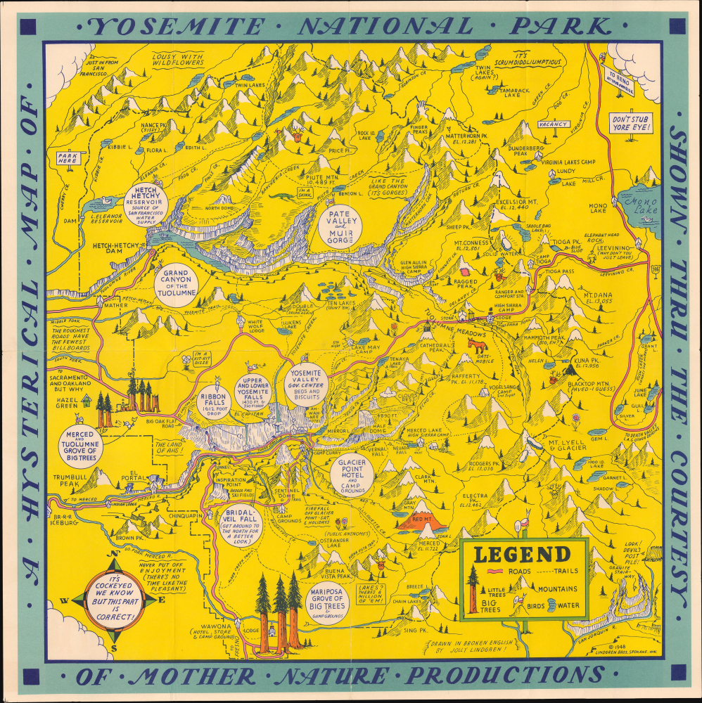
A Hysterical Map of Yosemite National Park shown through the Courtesy of Mother Nature Productions.
1948 (dated) 16 x 16 in (40.64 x 40.64 cm)
1948 (dated) 16 x 16 in (40.64 x 40.64 cm)
Description
This is the Lindgren Brothers 1849 Hysterical Map of Yosemite National Park, accompanied by its original mailer. This is one of the rarest Jolly Lindgren pictorial maps, published late in their career.
They emerged in the Interwar Period (1918 - 1939), an era defined by the breakdown of social structure, widespread disillusionment, the Great Depression, industrialization, and breakneck technological advances. In the United States, spurred by the ease of movement brought about by the automobile, infrastructure investment by New Deal programs, escapism into nature, and affordability, a nationwide love affair with our National Parks emerged - and remains.
The Lindgrens capitalized on this unique situation to introduce an affordable, mailable souvenir - the Hysterical Map. Both visually striking and funny, the Hysterical Map could be framed and displayed as a happy memento or folded and mailed to friends and family. The Lindgrens made maps of most of the Great National Parks, as well as other points of interest, though they kept a broad focus on the Western United States. Hysterical Maps remained in production until about 1954.Yosemite National Park, established in 1890, is one of the earliest national parks in the United States and a cornerstone of the American conservation movement. Located in California's Sierra Nevadas, the park is renowned for its dramatic granite cliffs, waterfalls, giant sequoias, and diverse ecosystems. Its protection was inspired by the advocacy of naturalist John Muir, whose writings helped convince Congress to preserve the area. Yosemite Valley was first protected in 1864 when President Abraham Lincoln signed the Yosemite Grant, marking the first time the federal government set aside land for public enjoyment and preservation. The area later became a national park under federal administration, laying the groundwork for the National Park System.
We invite readers to read our evolving cartobibliography of Lindgren Brothers maps here: Hysterical Maps of the Lindgren Brothers: A Cartobibliography
A Closer Look
Coverage centered loosely on Half Dome, and includes the Yosemite Valley, including Yosemite Valley, and the Muir Gorge. It extends east to encompass Mono Lake and south to the Mariposa Grove and the San Joaquin River. The borders of the park appear as a dashed line. The whole is rich with Jolly Lindgren's famous 'cockeyed' humor: Double Peak (Drunk Again), clouds incoming from San Francisco, Ragged Peak with a Patch, (Public Anenomes), etc.Unlike most Lindgren National Park maps, here a week-long itinerary is proposed,- 1st Night: Merced Lake High Sierra Camp
- 2nd Night: Vogelsang Camp
- 3rd Night: High Sierra Camp Lodge near Dana Fork
- 4th Night: Glen Aulin High Sierra Camp
- 5th Night: Lake May Camp
- 6th Night: A Wahnee Hotel
Lindgren Brothers Hysterical Maps
Starting in 1932, the Lindgren Brothers of Spokane, Washington, began issuing medium-format pictorial maps, mostly of national parks, which they dubbed 'Hysterical.' The maps were doubtless influenced by the comparable work of American mapmakers Jo Mora and Harrison Godwin, as well as international figures like MacDonald Gill. Lindgren maps were simply illustrated with primary colors and lighthearted content, meant to get a laugh or at least a raised eyebrow.They emerged in the Interwar Period (1918 - 1939), an era defined by the breakdown of social structure, widespread disillusionment, the Great Depression, industrialization, and breakneck technological advances. In the United States, spurred by the ease of movement brought about by the automobile, infrastructure investment by New Deal programs, escapism into nature, and affordability, a nationwide love affair with our National Parks emerged - and remains.
The Lindgrens capitalized on this unique situation to introduce an affordable, mailable souvenir - the Hysterical Map. Both visually striking and funny, the Hysterical Map could be framed and displayed as a happy memento or folded and mailed to friends and family. The Lindgrens made maps of most of the Great National Parks, as well as other points of interest, though they kept a broad focus on the Western United States. Hysterical Maps remained in production until about 1954.Yosemite National Park, established in 1890, is one of the earliest national parks in the United States and a cornerstone of the American conservation movement. Located in California's Sierra Nevadas, the park is renowned for its dramatic granite cliffs, waterfalls, giant sequoias, and diverse ecosystems. Its protection was inspired by the advocacy of naturalist John Muir, whose writings helped convince Congress to preserve the area. Yosemite Valley was first protected in 1864 when President Abraham Lincoln signed the Yosemite Grant, marking the first time the federal government set aside land for public enjoyment and preservation. The area later became a national park under federal administration, laying the groundwork for the National Park System.
Publication History and Census
This map was drawn by Jolly Lindgren and published by Lindgren Brothers of Spokane, Washington. It is among the rarest Lindgren maps, and also among the latest, being published in 1948. We note an example at the David Rumsey collection.We invite readers to read our evolving cartobibliography of Lindgren Brothers maps here: Hysterical Maps of the Lindgren Brothers: A Cartobibliography
Cartographer
Lindgren Brothers (1928 – 1971) was a Spokane, Washington, based printer known for issuing humorous souvenir auto decals, maps, and posters. The firm was founded as a sign-painting company by Hjalmer 'Jolly' Lindgren (1895 - September 1952) and his brother Oscar 'Ott' Lindgren (1893 - 1967), born in Wisconsin to Swedish immigrants. Neither brother had middle names when they went off to fight in World War I (1914 - 1818), but as the government required it, they adopted Jolly and Ott, which stuck with them for life. Jolly was in charge of the art department and Ott was in charge of the business aspects of the firm. The company began as printers and sign makers, and also became innovators in silkscreen printing, and as the Great Depression deepened, Jolly began producing 'hysterical maps'. He declared at the time, ‘What this country needs now is something to put a smile on people's faces.' The maps are graphically interesting and intended, as the titles suggest, to amuse. The brothers focused on producing maps of popular tourist attractions, and the great national parks of the West were an obvious choice. They produced maps of Yellowstone, the Grand Canyon, Glacier, Zion, Bryce Canyon and others through the early 1940s. Following a hiatus during World War II (1939 - 1945), the company began producing car decals, some of which were simplified versions of the ‘hysterical maps'. The company sold more than ten million decals in a good year. In 1949, the company was renamed the Lindgren-Turner Company when their traveling salesman, Theodore 'Ted' Turner, Jr. (1902 - 1989), who had been with the firm since 1930, became a partner. Jolly died unexpectedly at 57 while visiting his daughter in Boise, Idaho. The firm continued under his brother, Oscar. William Shigeo Terao (1915 - 1990), who was hired after World War II by the Lindgrens and eventually became the firm's art director, created two more hysterical maps following Jolly's death. The company's last great success, after the decal market had become too competitive, was a sign that read 'No Trespassing, Survivors will be Prosecuted'. The signs became a massive success, eventually being sold in every Woolworth's department store nationwide - all 2,228 locations. Ott died in 1967 at the age of 74, leaving Turner as the last member of the original team. He, in turn, sold the firm to the Emblem Manufacturing Company based in Los Angeles, in February 1971 and he and his wife moved to New Mexico three years later to be closer to their daughter. Turner wrote a history of the Lindgren-Turner Company during his retirement and died at the age of 87 in 1989. More by this mapmaker...
Condition
Very good. Original fold lines. Accompanies original branded mailer.
References
Clinton (IMCOS #125) pp. 27-39. Hornsby, S. J., Picturing America: The Golden Age of Pictorial Maps, p. 58. Rumsey 8798.000.