1949 Mora Pictorial Map of Yosemite National Park, California
Yosemite-mora-1949$1,000.00

Title
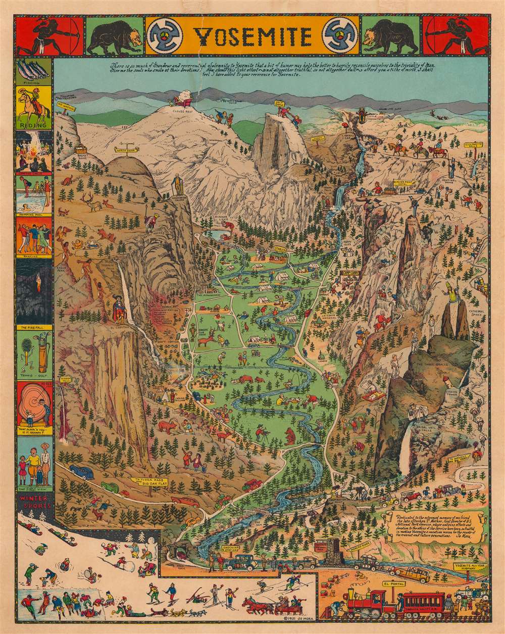
Yosemite.
1949 (dated) 18 x 14 in (45.72 x 35.56 cm)
1949 (dated) 18 x 14 in (45.72 x 35.56 cm)
Description
This is a 1949 Jo Mora pictorial map of Yosemite National Park in California. The map centers on Yosemite Valley and identifies several of the granite peaks that surround the valley, including Half Dome and El Capitan. Most of these are topped by comical illustrations of their names. A Spanish conquistador, for example, stands atop El Capitan, a cloud lounges in an easy chair at the summit of Clouds Rest (the highest peak around Yosemite Valley), and George Washington appears at the top of Washington Column. A bride in her wedding gown and veil peers over Bridalveil Falls, while a bishop precariously straddles Cathedral Spires. Vernal Falls, Nevada Falls, and Yosemite Falls are all illustrated and labeled.
The valley itself, as well as the granite heights surrounding it, is filled with tourists enjoying their time in the park. People are illustrated picnicking, camping, fishing, swimming in the river, feeding deer, and fleeing bears who have decided to help themselves to their picnic! Another visitor is taking a photographic portrait for a couple of bears. Still others appear on horseback or hiking the steep trails. Cars filled with awe-struck admirers of the landscape travel along the meandering roads toward campsites and lodges. A border featuring vignettes of activities at the park, including swimming, a campfire circle, horseback riding, winter sports, and fishing, is situated along the left side. A text box in the lower right corner bears a dedication to Mora's friend Stephen T. Mather, the first Director of the U.S. National Park Service.
The valley itself, as well as the granite heights surrounding it, is filled with tourists enjoying their time in the park. People are illustrated picnicking, camping, fishing, swimming in the river, feeding deer, and fleeing bears who have decided to help themselves to their picnic! Another visitor is taking a photographic portrait for a couple of bears. Still others appear on horseback or hiking the steep trails. Cars filled with awe-struck admirers of the landscape travel along the meandering roads toward campsites and lodges. A border featuring vignettes of activities at the park, including swimming, a campfire circle, horseback riding, winter sports, and fishing, is situated along the left side. A text box in the lower right corner bears a dedication to Mora's friend Stephen T. Mather, the first Director of the U.S. National Park Service.
Publication History and Census
This map was created by Jo Mora and first published in 1931 in black and white. At least two other colored editions were published in 1941 and 1949, respectively, with the current example corresponding to 1949, based on the addition of the sign that reads 'To Tioga Pass and Big Oak Flat'. On both the 1931 and 1941 editions, the sign reads simply 'To Big Oak Flat'.Cartographer
Joseph 'Jo' Jancito Mora (October 22, 1876 – October 10, 1947) was an Uruguayan born artist active in California during the first half of the 20th century. Mora immigrated to California as a young man. He studied art in Boston and, after graduating, worked there briefly before relocating to California. In cartographic circles Mora is known for pioneering the 20th century pictorial map. In a series he referred to as his 'cartes,' published between in 1926 and 1942, Mora developed a pictorial style that combined cartography with colorful cartoonish image of local figures, folklore, history, and natural wonders. His earliest maps were commissioned by the Hotel Del Monte and included California's Playground and The Seventeen Mile Drive. As he matured as a cartographer, his work became increasingly dense, often packed with tiny figures, each expressive of some aspect of regional life. Mora, often called the 'Renaissance man of the West' also worked as an illustrator, muralist, sculptor, photographer, and writer. His masterpiece is considered to be the Father Serra Cenotaph, a bronze and marble sculpture at the Memorial Chapel in El Carmelo Mission, Carmel, California. His map work included Monterey Penninsula (1927), and Seventeen Mile Drive (1927), California (1927), Grand Canyon (1931), Yosemite (1931), Yellowstone (1936), Carmel-By-The-Sea (1942), California (1945) (large and small versions), Map of Los Angeles (1942), among others. More by this mapmaker...
Condition
Good. Mounted on heavy linen. Closed tear extending three-and-three-quarters (3.75) inches into printed area from top margin professionally repaired. Light cracking.