1902 Underwood and Underwood Map of Yosemite Valley, California
Yosemite-underwoodunderwood-1902$200.00
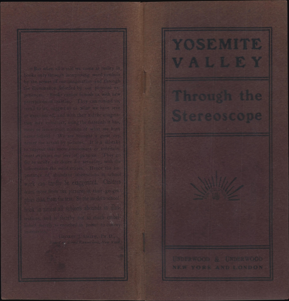

Title
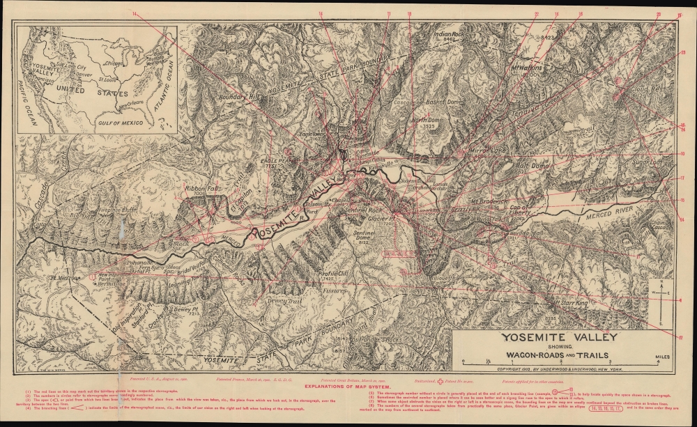
Yosemite Valley Showing Wagon-Roads and Trails.
1902 (dated) 10.75 x 18 in (27.305 x 45.72 cm) 1 : 47700
1902 (dated) 10.75 x 18 in (27.305 x 45.72 cm) 1 : 47700
Description
A highly detailed topographic map of Yosemite Valley published by Underwood and Underwood in 1902 as part of the booklet Yosemite Valley through the Stereoscope.
In July 1861, Watkins ventured to Yosemite with two cameras, one stereoscopic and the other being a mammoth-plate camera (using 18 by 22 inch glass plates). When he returned to San Francisco, Watkins had more than 130 images, which were quickly brought to New York City and displayed in 1862, to public astonishment. Watkins' photographs have been credited with convincing the U.S. Congress to protect the valley two years later and remain among the most iconic images of Yosemite ever captured. A train of photographers, including Eadweard Muybridge and Ansel Adams, followed in Watkins' footsteps, deploying improved technologies to attempt ever-grander images of the valley's stunning landscapes.
A Closer Look
A topographic map of the valley and its surroundings, noting peaks with their elevations, waterfalls, cliffs, hiking trails, wagons roads, and several small settlements and camps. The major wagon roads, alluded to in the title, are Big Oak Flat Road, Glacier Point Road, Wawona Road (not labelled), and the Coulterville Road (not labeled). Major landmarks such as El Capitan, Cathedral Rocks, Bridal Veil Falls, Glacier Point, North Dome, and more are also labeled. A small inset map of the United States appears at top-left, demonstrating the location of Yosemite within California and within the country as a whole. Red overprint indicates the location and perspective of the stereograph photographs in the accompanying booklet, while red text at bottom provides a full guide for using the map in conjunction with the photographs.Yosemite State Park?
The Yosemite State Park Boundary present here is perplexing to a modern observer, but this was a legacy of the original legislation and agreements established to protect the area, in which the most majestic part of the Yosemite Valley was established as a federal grant (later a national park) while the surrounding area and Mariposa Grove were set aside as a California State Park. In 1903, shortly after this map's publication, President Theodore Roosevelt made a consequential visit to Yosemite. While there, he met with John Muir, who helped convince Roosevelt that dividing Yosemite between state and federal control was problematic and inefficient. Upon returning to Washington, Roosevelt successfully advocated for the Yosemite Recession Bill, which he signed in June 1906, placing the entire Yosemite Valley and Mariposa Grove under federal protection.Photographing Yosemite
Yosemite captured the imagination of nearly all the early Americans who visited it, resulting soon afterward in travelogues and paeons to the area's natural beauty, as well as attempts to photograph it. The first photographer to capture Yosemite was Charles Leander Weed (1824 - 1903) in 1859, who displayed them in San Francisco the same year, increasing public interest in the region. Weed's work greatly influenced Carleton Watkins (1829 - 1916), who unquestionably became the most influential early photographer of the valley. A childhood friend of Collis Huntington (1821 - 1900), who went on to become one of the wealthiest men in California, Watkins moved to California soon after the Gold Rush with no knowledge of or experience with photography. Falling into the profession rather accidentally after moving to San Francisco, Watkins proved adept at capturing compelling scenes with Daguerreotype technology, including stereoviews, which produced two nearly identical images which could be placed side-by-side to mimic the illusion of depth and three-dimensionality.In July 1861, Watkins ventured to Yosemite with two cameras, one stereoscopic and the other being a mammoth-plate camera (using 18 by 22 inch glass plates). When he returned to San Francisco, Watkins had more than 130 images, which were quickly brought to New York City and displayed in 1862, to public astonishment. Watkins' photographs have been credited with convincing the U.S. Congress to protect the valley two years later and remain among the most iconic images of Yosemite ever captured. A train of photographers, including Eadweard Muybridge and Ansel Adams, followed in Watkins' footsteps, deploying improved technologies to attempt ever-grander images of the valley's stunning landscapes.
Roads to and through Yosemite
Soon after the Yosemite Valley became well-known for its natural beauty in the mid-19th century, efforts were made to establish wagon roads to the valley. Initially, these followed Native American routes. By the late 1860s, plans were put into place to expand existing dirt trails (the Coulterville Road) and build an entirely new road (the Big Oak Flat Road), allowing access to Yosemite Valley from the west. Both projects ran into technical, financial, and political obstacles but were driven by competition against each other and the popular demand for such a route. Both roads were completed in 1874 within a month of each other (neither made much money despite charging tolls since travelers could always choose the other route if it was less expensive). The following year, a road further south from Mariposa was also constructed. Nevertheless, these stagecoach roads took two days from the nearest cities and were dangerous, not least because of highway robbers. The Southern Pacific Railroad had built a partial line to Yosemite Valley, but still relied on stagecoaches for most of the journey. Thus, there was a strong argument to be made for constructing a railroad to the valley, which was completed in the first decade of the 20th century as the Yosemite Valley Railroad, terminating at El Portal, just to the west of the area seen here. This project proved even more challenging than the construction of stagecoach roads, but was successful once operations began in 1907. However, by 1918 the Glacier Point Road seen here had been paved, signaling the coming dominance of private automobiles.Publication History and Census
This map was printed by the 'The M-N Works' (quite possibly the New York-based Matthews-Northrup Works) and published by Underwood and Underwood in 1902 as part of Charles Quincy Turner's booklet Yosemite Valley through the Stereoscope. The map is not independently cataloged in the OCLC, while the booklet appears in the holdings of about twenty-five institutions in the OCLC (some listings co-mingle digital and physical examples, making a precise census difficult).Cartographer
Matthews-Northrup Works (fl. c. 1895 - 1930) were a Buffalo, New York based, in their own words, "writing, designing, engraving, printing, [and] binding" firm. The firm was founded by James Newson Matthews (November 21, 1828 - December 20, 1888) as the J. N. Matthews Company. William Phelps Northrup (April 2, 1850 - February 2, 1929) later joined the company as an apprentice and then partner, at which point the firm was reincorporated as the Matthews-Northrup Works. The Matthews-Northrup Works rose to prominence as publishers and printers of railroad maps, with dozens to their credit. When James died, his shares were inhered by George Edward Matthews (1855 - 1910), who ran the business until his death in 1910. Also in 1910, they famously redesigned the cover of National Geographic Magazine. Despite some six previous cover changes in just 21 years, the Matthews-Northrup layout proved so popular that it was used for nearly 50 years. The firm can also take credit for the Winchell typeface, designed in 1903 under E. E. Winchell's tenure as art director. Curiously, the partners of Matthews-Northrup maintained an unusual affectation in which only the officers of the company could wear beards or mustaches. In this same spirit, the firm also had its own private social club, the Fellowcraft Club, where the all-male employees could relax, play pool, drink and dine. Matthews-Northrup maintained offices on Washington Street, Buffalo, where they were based, as well as Madison Square, New York City, Garden Tower, Boston, and the Citizens Building in Cleveland. More by this mapmaker...
Source
Turner, C. Q., Yosemite Valley through the Stereoscope, (New York: Underwood and Underwood) 1902.
Condition
Good. Light wear along original folds. Some loss along fold junction at left.
References
Entire booklet - OCLC 936902976 (co-mingles digital and physical examples), 59557080, 774536537.