This item has been sold, but you can get on the Waitlist to be notified if another example becomes available, or purchase a digital scan.
1930 U.S.G.S. Map of Yosemite National Park Glaciers
YosemiteGlaciers-usgs-1930$75.00

Title
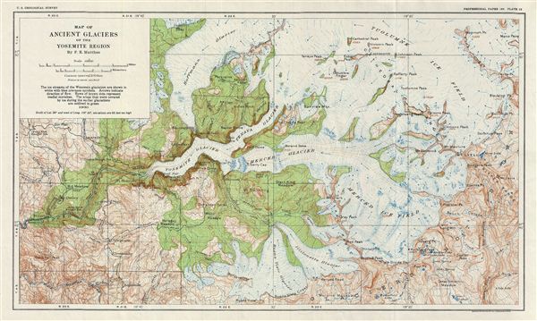
Map of Ancient Glaciers of the Yosemite Region By F. E. Matthes.
1930 (dated) 11.5 x 18.5 in (29.21 x 46.99 cm)
1930 (dated) 11.5 x 18.5 in (29.21 x 46.99 cm)
Description
A fine example of Francois e. Matthes' 1930 geological survey map of the spectacular Ancient Glaciers of the Yosemite Valley, California. Centered on Liberty Cap, the map depicts the ice streams of the Wisconsin glaciation and covers from Mammoth peak to the south fork of the Merced River. Throughout countless well known Yosemite sites are noted, including old Inspiration point, Pinoche Peak Trail, and Half Dome, as well as various peaks, meadows, trails, mountain passes, rivers and creeks. The glaciers in the Yosemite formed over a million years ago and as they moved down, they carved the rocks into the U-shaped valley we know today. The map is color coded and shows the direction of the flow of the glaciers. This particular map was published as plate 39 by the United States Geological Survey in 1930 as part of the Geological History of the Yosemite Valley.
Cartographer
The Office of the Coast Survey (later the U.S. Geodetic Survey) (1807 - present), founded in 1807 by President Thomas Jefferson and Secretary of Commerce Albert Gallatin, is the oldest scientific organization in the U.S. Federal Government. Jefferson created the "Survey of the Coast," as it was then called, in response to a need for accurate navigational charts of the new nation's coasts and harbors. The first superintendent of the Coast Survey was Swiss immigrant and West Point mathematics professor Ferdinand Hassler. Under the direction of Hassler, from 1816 to 1843, the ideological and scientific foundations for the Coast Survey were established. Hassler, and the Coast Survey under him developed a reputation for uncompromising dedication to the principles of accuracy and excellence. Hassler lead the Coast Survey until his death in 1843, at which time Alexander Dallas Bache, a great-grandson of Benjamin Franklin, took the helm. Under the leadership A. D. Bache, the Coast Survey did most of its most important work. During his Superintendence, from 1843 to 1865, Bache was steadfast advocate of American science and navigation and in fact founded the American Academy of Sciences. Bache was succeeded by Benjamin Pierce who ran the Survey from 1867 to 1874. Pierce was in turn succeeded by Carlile Pollock Patterson who was Superintendent from 1874 to 1881. In 1878, under Patterson's superintendence, the U.S. Coast Survey was reorganized as the U.S. Coast and Geodetic Survey (C & GS or USGS) to accommodate topographic as well as nautical surveys. Today the Coast Survey is part of the National Oceanic and Atmospheric Administration or NOAA. More by this mapmaker...
Source
Matthes, F. E., Geologic History of the Yosemite Valley, (Washington, USGS) 1930.
Condition
Very good. Original fold lines visible. Blank on verso.