
1886 Norris Wooden Geography Game Zylo-Karta

This item has been sold.
New, Unique, Interesting, Instructive and Beneficial Zylo-Karta Games.
'Very popular in the leading homes of Washington, D.C., including the 'White House,' and in the homes of cultured, refined and Christian people in all parts of the country.'
Choose a Collection:
This Item
Enquire
'Very popular in the leading homes of Washington, D.C., including the 'White House,' and in the homes of cultured, refined and Christian people in all parts of the country.'
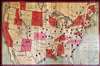
The Zylo-Karta, an unusual 1886 rolling wooden game board map published by William R. Norris. The novel game, supposedly a sensation in the 1880s, reaching even the White House, offers a unique approach to teaching geography.A Closer Look
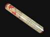
The name 'Zylo-Karta' literally means wooden map. It is printed on wooden tambour slats that roll for storage. The game board is pierced with about 100 square holes to accommodate 'city pins', wooden pegs printed with city names, population, and other data - these are not present. The game is thus intended to teach politics and geography. The game is promoted asVery popular in the leading homes of Washington, D.C., including the 'White House,' and in the homes of cultured, refined and Christian people in all parts of the country.We wonder how much time Grover Cleveland had for playing 'Zylo-Karta'?
On December 20, the following small advertisement appeared in the New York Times,
ZYLO-KARTA.
A NOVEL EXHIBITION ON FOURTEENTH-STREET.
A window at 44 West Fourteenth Street is now attracting throngs of people. In it are seated several persons engaged in playing the new game Zylo-Karta. This might be described as geographical chess. It is really a series of games, consisting of 97 blocks and a map of the United States. Each State is marked to separate coloring, and each block fits into a hole representing a city. Several games may be played on the Zylo-Karta board, adapted to the intellect of a child or to that of a skilled chess player. W.R. Norris of Schenectady, N.Y., the inventor and manufacturer of Zylo-Karta, gives free instruction in the games this week at his place on Fourteenth Street. Hundreds of people saw the games played yesterday, and Mr. Norris, who merely exhibited them experimentally, is now obliged to arrange for a large sale after the holidays. His invention is a delightful holiday gift.
Publication History and Census
The map bears a patent date of June 13, 1883. We are aware of earlier versions of the game. One dated roughly 1884, bears the title Norris' Map of the United States of America together with adjacent portions of the Dominion of Canada and the United States of Mexico. Another, dated 1885, is titled Norris' Cyclopaedic Map of the United States of America. All examples are scarce.Condition
Very good. Game board only. No pieces.