
Carteret, Philip Seigneur of Trinity

Philip Carteret, Seigneur of Trinity (January 22, 1733 - July 21 1796) was a British naval officer and explorer who participated in two of the Royal Navy's circumnavigation expeditions in 1764–66 and 1766–69. He served as a lieutenant aboard HMS Dolphin under Byron during his voyage of circumnavigation from June 1764 to May 1766. Later that year he was made commander and given the command of HMS Swallow to circumnavigate the world, as supporting HMS Dolphin under the command of Samuel Wallis. The two ships were separated after passing through the Strait of Magellan, but Carteret continued his circumnavigation aboard Swallow. During the voyage he discovered both Pitcairn Island and the Carteret Islands, which were subsequently named after him. In 1767, he discovered a new archipelago inside Saint George's Channel between New Ireland and New Britain Islands, and rediscovered the Solomon Islands first sighted by the Spaniard Álvaro de Mendaña in 1568, and the Juan Fernández Islands first discovered by Juan Fernández in 1574.
Early maps of features in the western Pacific.
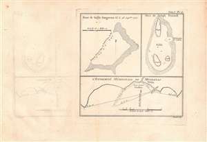
Banc de sable dangereux Vû le 28 Septbre. 1767; Isles de Joseph Freewell; l'extremité méridionale de Mindanao.
$125.00
Acquire
- Digital Map Information
- Suitable for large format printing
- DPI: 600
- File Size: 16.03 MB
- File Type: ZIP / TIFF
- ICC color profile embedded
- Delivered instantly via download link
Three maps on a single sheet. The map detailas geographic features encountered in the western Pacific during a 1766 - 1769 British voyage of circumnavigation captained by Philip Carteret. They were engraved by Robert Benard and published in the 1774 French translation of John Hawkesworth's An Account of the Voyages…, a very popular work which helped publicize British discoveries in the Pacific. (more details)
Named for Selkirk, inspiration for Robinson Crusoe.
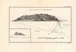
Vue du Côté N.O. de Masafuero.
$150.00
Acquire
- Digital Map Information
- Suitable for large format printing
- DPI: 600
- File Size: 14.84 MB
- File Type: ZIP / TIFF
- ICC color profile embedded
- Delivered instantly via download link
This 1774 view and chart details Más Afuera Island (now Alejandro Selkirk Island), encountered on a 1766 - 1769 British voyage of circumnavigation captained by Philip Carteret. It was engraved by Robert Benard and published in the 1774 French translation of John Hawkesworth's An Account of the Voyages…, a very popular work which helped publicize British discoveries in the Pacific. (more details)
Volcanoes and violence in the Solomons.
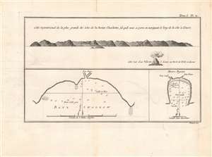
Cote Septentrional de la plus grande des Isles de la Reine Charlotte / Baye Swallow / Havre Byron.
$100.00
Acquire
- Digital Map Information
- Suitable for large format printing
- DPI: 600
- File Size: 15.46 MB
- File Type: ZIP / TIFF
- ICC color profile embedded
- Delivered instantly via download link
This is a nice example of Philip Carteret's 1774 view and chart of the largest of the Queen Charlotte Islands (Nendö Island) in the Santa Cruz Islands, now part of the Solomon Islands (not to be confused with Queen Charlotte Islands in Southern Alaska, or the Queen Charlotte Island now known as Nukutavake in the Tuamotu Archipelago of French Polynesia). It was published in the French translation of John Hawkesworth's wildly successful An Account of the Voyages…. (more details)
The Solomon Islands, Rediscovered and Renamed by Carteret
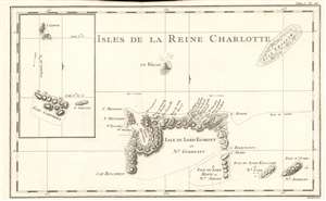
Isles De La Reine Charlotte.
$200.00
Acquire
- Digital Map Information
- Suitable for large format printing
- DPI: 600
- File Size: 5.46 MB
- File Type: ZIP / TIFF
- ICC color profile embedded
- Delivered instantly via download link
This is a 1774 map of the Solomon Islands, renamed by Carteret after his 'rediscovery' of the islands during his calamitous 1767 journey around the world. The map is beautifully engraved, with topography shown pictorially, and showning predominant winds. The map shows the track of HMS Swallow through the islands; there is a volcanic island shown centrally - this is Tinakula island, an island stratovolcano which last erupted in 2012 and whose earliest recorded eruption dates to the Álvaro de Mendaña expediion of 1595 . (more details)
Circumnavigators visit Paradise.
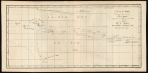
Carte des Isles découvertes aux environs d'Otahiti, dans plusieurs Voyages faits autour du Monde Par les Capitaines Byron, Wallis, Carteret et Cook en 1765, 1767, 1769.
$400.00
Acquire
- Digital Map Information
- Suitable for large format printing
- File Size: 8.64 MB
- File Type: ZIP / TIFF
- ICC color profile embedded
- Delivered instantly via download link
This is a 1774 map showing the explorations of Captains Cook, Byron, Wallis, and Carteret in the vicinity of Tahiti and the Society Islands from 1765 to 1769. The chart extends from the Scilly Islands in the west to Whitsunday Island in the east and from Tepoto Island in the north to Oheiroa in the south. Each of the circumnavigators' tracks is shown as they tacked through the islands. Tahiti, Bora Bora, Otaha, Marma, Ulietea, and other islands are named and shown. These voyages represented the first recorded European contacts with many of these remote places. (more details)