
This item below is out of stock, but another example (left) is available. To view the available item, click "Details."
Details
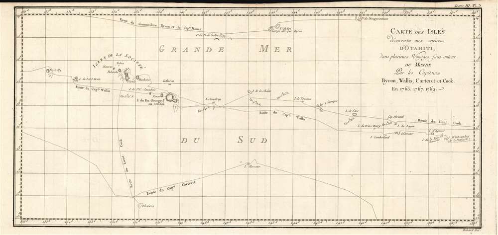
1774 Benard/ Hawkesworth Map of the Society Islands and Tahiti
$400.00
1774 Benard/ Hawkesworth Map of the Society Islands and Tahiti
OtahitiDecouverts-benard-1774$175.00

Title
Carte Des Isles Decouvertes Aux Environs D'Otahiti, dans Plusieurs Voyages Faits Autour Du Monde Par Les Capitaines Byron, Wallis, Carteret et Cook. En 1765, 1767,1769.
1774 (undated) 9.25 x 20 in (23.495 x 50.8 cm) 1 : 4400000
1774 (undated) 9.25 x 20 in (23.495 x 50.8 cm) 1 : 4400000
Description
This is a 1774 map showing the explorations of Captains Cook, Byron, Wallis and Carteret in the vicinity of Tahiti and the Society Islands from 1765 to 1769. The chart extends from the Scilly Islands in the west to Whitsunday Island in the east, and from Tepoto Island in the north to Oheiroa in the south. Each of the circumnavigators' tracks are shown as they tacked through the islands. Tahiti, Bora Bora, Otaha, Marma, Ulietea, and other islands are named and shown. These voyages represented the first recorded European contacts with many of these remote places.
Byron
Byron's scurvy-ridden flotilla passed well north of most of the archipelago, arriving at Tepoto, a paradisiacal island, only to be warned off at the beach by islanders brandishing five-meter pikes. A frustrated Byron would name the place 'Disappointment Island,' as it appears on this chart. (Not to be mistaken with the similarly named island south of New Zealand.)Wallis and Carteret, 1767
Though hey set out together, the tracks of the Wallis' Dolphin and Carteret's Swallow diverged as they entered the Pacific, never to rejoin. Dolphin, stocked with an abundant supply of sauerkraut, had enjoyed a relatively easy trans-Pacific voyage, and were fortunate in being able to perform a thorough survey of the islands here. During this journey, Wallis made the first European discovery of Tahiti. Swallow's journey, on the other hand, was like Byron's characterized mainly by scurvy and unfriendly natives. More than half Carteret's crew died on the voyage. His track largely missed the Society Islands, as is reflected on the chart here.Cook, 1769
The great explorer Cook's first Pacific voyage was undertaken specifically in order to observe the 1769 transit of Venus from Tahiti. His track from the Strait of Le Maire had led southwest to sixty degrees latitude south after rounding Cape Horn - this, in order to find evidence of the legendary Terra Australis Incognita. Finding none, Cook then sailed northwest - explaining why his approach to Tahiti was from the south, rather than the east.Friendly Natives
Among Cook's observations on Tahiti was that of the rampant venereal disease on the island, which had not been evident during HMS Dolphin's 1767 visit. Captain Wallis would later deny the blame for this affliction, laying it rather at the feet of the French: Bougainville, specifically.Publication History and Census
This map was engraved by Robert Bénard for the 1774 French edition of James Hawkesworth's Relation des voyages entrepris par ordre de Sa Majeste britannique actuellement regnante, an account of Cook's voyages. The separate engraving appears to be neglected by institutional collections, appearing only in the National Library of Australia. The full text is well represented in institutional collections.CartographerS
Robert Bénard (1734 - c. 1785) was a French engraver. Born in Paris, Bénard is best known for supplying a significant number of plates (at least 1,800) for the Encyclopédie published by Diderot and Alembert. He also is remembered for his work with the Académie des Sciences, most notably the Descriptions des Arts et Métiers More by this mapmaker...
John Hawkesworth (c. 1715 - November 16, 1773) was an English born writer and editor born London. Hawkesworth, who is said to have been self educated, succeeded Samuel Johnson as the parliamentary debate compiler for "Gentleman's Magazine". He was a deeply religious and moral map who brilliant defense of morality earned him an LL. D degree from the Archbishop of Canterbury. Hawkesworth went on to publish a series of scholarly books and essays including a 12 volume edition of Jonathan Swift's work. In 1772 Hawkesworth was commissioned by the Admiralty to compile and edit James Cook's journals. The resultant work An Account of the Voyages undertaken ... for making discoveries in the Southern Hemisphere was one of the first ethnographic account of the South Seas and was widely published in England and abroad. Though highly influential, Hawkesworth's work received heavy criticism from scholars who claim that he liberally altered much of the text in the name of morality. Learn More...
Philip Carteret, Seigneur of Trinity (January 22, 1733 - July 21 1796) was a British naval officer and explorer who participated in two of the Royal Navy's circumnavigation expeditions in 1764–66 and 1766–69. He served as a lieutenant aboard HMS Dolphin under Byron during his voyage of circumnavigation from June 1764 to May 1766. Later that year he was made commander and given the command of HMS Swallow to circumnavigate the world, as supporting HMS Dolphin under the command of Samuel Wallis. The two ships were separated after passing through the Strait of Magellan, but Carteret continued his circumnavigation aboard Swallow. During the voyage he discovered both Pitcairn Island and the Carteret Islands, which were subsequently named after him. In 1767, he discovered a new archipelago inside Saint George's Channel between New Ireland and New Britain Islands, and rediscovered the Solomon Islands first sighted by the Spaniard Álvaro de Mendaña in 1568, and the Juan Fernández Islands first discovered by Juan Fernández in 1574. Learn More...
Captain James Cook (7 November 1728 - 14 February 1779) is a seminal figure in the history of cartography for which we can offer only a cursory treatment here. Cook began sailing as a teenager in the British Merchant Navy before joining the Royal Navy in 1755. He was posted in America for a time where he worked Samuel Holland, William Bligh, and others in the mapping of the St. Lawrence River and Newfoundland. In 1766 Cook was commissioned to explore the Pacific and given a Captaincy with command of the Endeavour. What followed were three historic voyages of discovery, the highlights of which include the first European contact with eastern Australia, the discovery of the Hawaiian Islands (among many other Polynesian groups), the first circumnavigation of New Zealand, some of the first sightings of Antarctica, the first accurate mapping of the Pacific Northwest, and ultimately his own untimely death at the hands of angry Hawaiians in 1779. The influence of Cook work on the mapping and exploration of the Pacific cannot be understated. Learn More...
Source
Hawkesworth, John Relation des voyages entrepris par ordre de Sa Majeste britannique actuellement regnante. (Paris : Chez Saillant et Nyon) 1774
Condition
Very good condition. Margin close at top but complete. No mends or stains.
References
OCLC 224556555.