1774 Benard / Carteret View of the Santa Cruz Islands, Solomon Islands
SantaCruzIslands-benard-1774$100.00

Title
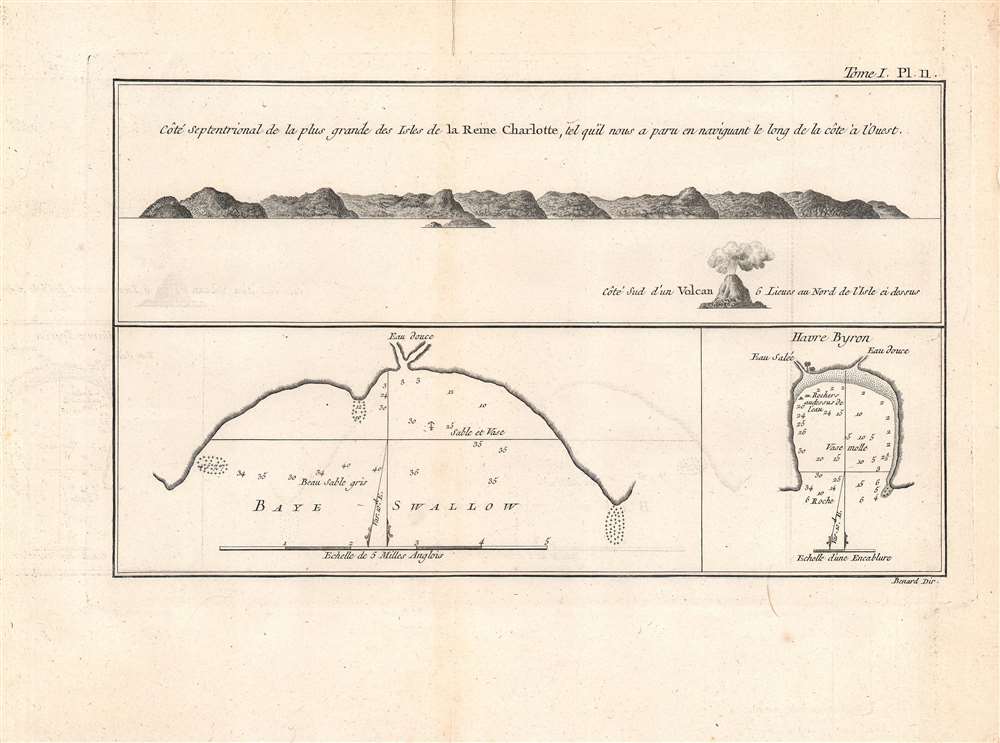
Cote Septentrional de la plus grande des Isles de la Reine Charlotte / Baye Swallow / Havre Byron.
1774 (undated) 6.5 x 11 in (16.51 x 27.94 cm)
1774 (undated) 6.5 x 11 in (16.51 x 27.94 cm)
Description
This is a nice example of Philip Carteret's 1774 view and chart of the largest of the Queen Charlotte Islands (Nendö Island) in the Santa Cruz Islands, now part of the Solomon Islands (not to be confused with Queen Charlotte Islands in Southern Alaska, or the Queen Charlotte Island now known as Nukutavake in the Tuamotu Archipelago of French Polynesia). It was published in the French translation of John Hawkesworth's wildly successful An Account of the Voyages….
Although not noted here, Carteret named Nendö as 'Lord Egmont's Island,' though the Spanish who had briefly established a colony there nearly two centuries before had named it 'Santa Cruz.' When Carteret sent a party ashore to seek water and examine the island, the party's leader offended the native inhabitants and a scuffle ensued resulting in several deaths. Carteret was therefore unable to use the island for badly needed food and water for his weary and mostly sick crew.
A Closer Look
This set of a view and two charts are based on sketches by Philip Carteret, who led British circumnavigation expedition ins 1764 - 66 and 1766 - 69. The view at top shows the north side of Nendö Island in profile, along with a volcano to the north of the island. The charts are rich with information, including soundings, anchorages, hazards, variations, nature of the ocean floor at various points, and sources of fresh water.Although not noted here, Carteret named Nendö as 'Lord Egmont's Island,' though the Spanish who had briefly established a colony there nearly two centuries before had named it 'Santa Cruz.' When Carteret sent a party ashore to seek water and examine the island, the party's leader offended the native inhabitants and a scuffle ensued resulting in several deaths. Carteret was therefore unable to use the island for badly needed food and water for his weary and mostly sick crew.
Publication History and Census
This view was based on a drawing by Philip Carteret and was engraved by Robert Benard. It appeared as Plate 11 in Volume 1 of Relation des voyages entrepris par ordre de Sa Majesté Britannique, actuellement regnante, pour faire des découvertes dans l'hémisphère méridional, a 1774 French translation of the English-language book An Account of the Voyages… published the previous year by John Hawkesworth. The map is only independently cataloged in the holdings of the National Library of Australia, while the English-language original ('The North side of the largest of Queen Charlotte's Islands… / Swallow's Bay / Byron Harbor') is held by the University of British Columbia and the David Rumsey Historical Map Collection. Hawkesworth's entire text is more widely distributed in institutional holdings, though somewhat less so in the French translation.CartographerS
Robert Bénard (1734 - c. 1785) was a French engraver. Born in Paris, Bénard is best known for supplying a significant number of plates (at least 1,800) for the Encyclopédie published by Diderot and Alembert. He also is remembered for his work with the Académie des Sciences, most notably the Descriptions des Arts et Métiers More by this mapmaker...
Philip Carteret, Seigneur of Trinity (January 22, 1733 - July 21 1796) was a British naval officer and explorer who participated in two of the Royal Navy's circumnavigation expeditions in 1764–66 and 1766–69. He served as a lieutenant aboard HMS Dolphin under Byron during his voyage of circumnavigation from June 1764 to May 1766. Later that year he was made commander and given the command of HMS Swallow to circumnavigate the world, as supporting HMS Dolphin under the command of Samuel Wallis. The two ships were separated after passing through the Strait of Magellan, but Carteret continued his circumnavigation aboard Swallow. During the voyage he discovered both Pitcairn Island and the Carteret Islands, which were subsequently named after him. In 1767, he discovered a new archipelago inside Saint George's Channel between New Ireland and New Britain Islands, and rediscovered the Solomon Islands first sighted by the Spaniard Álvaro de Mendaña in 1568, and the Juan Fernández Islands first discovered by Juan Fernández in 1574. Learn More...
John Hawkesworth (c. 1715 - November 16, 1773) was an English born writer and editor born London. Hawkesworth, who is said to have been self educated, succeeded Samuel Johnson as the parliamentary debate compiler for "Gentleman's Magazine". He was a deeply religious and moral map who brilliant defense of morality earned him an LL. D degree from the Archbishop of Canterbury. Hawkesworth went on to publish a series of scholarly books and essays including a 12 volume edition of Jonathan Swift's work. In 1772 Hawkesworth was commissioned by the Admiralty to compile and edit James Cook's journals. The resultant work An Account of the Voyages undertaken ... for making discoveries in the Southern Hemisphere was one of the first ethnographic account of the South Seas and was widely published in England and abroad. Though highly influential, Hawkesworth's work received heavy criticism from scholars who claim that he liberally altered much of the text in the name of morality. Learn More...
Source
Hawkesworth, John, Relation des voyages entrepris par ordre de Sa Majeste britannique actuellement regnante, (Paris: Chez Saillant et Nyon) 1774.
Condition
Good. Repaired wormhole in top margin. Offsetting present at left and right-center.
References
Rumsey 3403.014 (English edition). OCLC 495306817.