
Cellarius, Andreas

Andreas Cellarius (1596 - 1665) was a Dutch-German cartographer, mathematician, and astronomer. He was born in Neuhausen (now a part of Worms), and was educated in Heidelberg. Cellarius, being Protestant, may have left Heidelberg in 1618, at the onset of the Thirty Years' War, or slightly later, in 1622, when the city fell to Catholics. His activities are unclear at this time but based on his later works it is conjectured he spent time in Poland where he may have taken work as a military engineer. In 1625. he married Catharina Eltemans in Amsterdam, where he taught Latin. After a brief stay in The Hague, the family moved to Hoorn. From 1637 until his death he was rector of the Hoorn Latin School. Today Cellarius is best known for his Harmonia Macrocosmica of 1660, a major celestial atlas, published in Amsterdam by Johannes Janssonius.
Van Santen's matchless coloring heightened with lavish gold gilt.
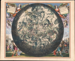
Haemisphaerium Stellatum Boreale cum Subiecto Haemisphaerio Terrestri.
$15,000.00
Acquire
- Digital Map Information
- Suitable for large format printing
- Full resolution TIFF file
- ICC color profile embedded
- Delivered instantly via download link
An exemplar regium of Andreas Cellarius's 1661 celestial map of the northern constellations with astounding Dirk Jansz Van Santen color. This chart stands out as an exemplary piece from a chart series long known for lavish presentation due both to fine engraving and the extraordinary colorwork of Van Santen. (more details)
Brahe's Model with Van Santen's matchless coloring heightened with lavish gold.
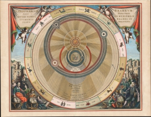
Planisphaerium Braheum Sive Structura Mundi Totius Ex Hypothesi Tychonis Braehi In Plano Delineata.
$15,000.00
Acquire
- Digital Map Information
- Suitable for large format printing
- Full resolution TIFF file
- ICC color profile embedded
- Delivered instantly via download link
An exemplar regium of Andreas Cellarius' 1661 celestial chart depicting the Solar system after the fascinating model of Tycho Brahe, embellished with astounding Dirk Jansz Van Santen color and gilt illumination. (more details)
Copernicus Centers the Sun.
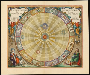
Planisphaerium Copernicanum Sive Systema Universi Totius Creati Ex Hypothesi Copernicana in Plano Exhibitum.
$4,500.00
Acquire
- Digital Map Information
- Suitable for large format printing
- File Size: 27.24 MB
- File Type: ZIP / TIFF
- ICC color profile embedded
- Delivered instantly via download link
This beautiful work is Andreas Cellarius' celestial chart, in its 1708 Valk and Schenk edition, illustrating the solar system theorized by Nicolaus Copernicus in the 16th century. It is among the most vivid and unambiguous depictions of the heliocentric solar system produced in the 17th century. (more details)
Visualizing the Celestial Sphere.

Situs Terrae Circulis Coelestibus Circundatae.
$1,800.00
Acquire
- Digital Map Information
- Suitable for large format printing
- DPI: 600
- File Size: 62.91 MB
- File Type: ZIP / TIFF
- ICC color profile embedded
- Delivered instantly via download link
This beautiful work is Andreas Cellarius' celestial chart, in its 1708 Valk and Schenk edition, illustrating the position of the Earth within the celestial sphere divided into its circles. Its lush, baroque presentation - filled with clouds, putti, and muses - frames a useful visual glossary illustrating terminology important both to the astronomer and to the geographer. (more details)