This item has been sold, but you can get on the Waitlist to be notified if another example becomes available, or purchase a digital scan.
1660 / 1661 Andreas Cellarius Astrological Chart
TypusAspectuum-cellarius-1660$1,250.00

Title
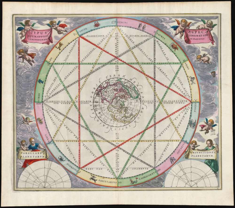
Typus Aspectuum Oppositionum et Conjunctionum Etz In Planetis.
1660 (undated) 17 x 20 in (43.18 x 50.8 cm)
1660 (undated) 17 x 20 in (43.18 x 50.8 cm)
Description
This beautiful work is Andreas Cellarius' 1660 astrological chart, in its second 1661 edition with beautiful original color. The work illustrates how planetary positions affect the 'humors', and thus human behavior.
A Closer Look
Around the circumference of the chart are the signs of the Zodiac; a network of lines indicates various relationships between those astrological signs and the bodily humours thought to govern personality. When consulted in conjunction with the observed positions of the planets at a given time, astrologers used charts of this type to derive insights into the human condition. The chart's primary focus, the 'Opposition Aspect,' refers to the effect of two planets being across the Zodiac wheel from one another (their energies, therefore, being at odds with one another). The chart's subordinate diagrams in the lower corners illustrate the importance of the observer's position relative to the planets and the idea of planetary conjunction.A Beautifully Decorated Work
At the center of the chart is a polar projection of the northern hemisphere, showing a mapping of the north contemporary to the production of this piece: the Asian coast is pre-Witsen, and at North America's west coast is a prominent California-as-an-island. Cellarius' lush, baroque presentation frames the chart, with a sky filled with putti and other figures displaying the chart's title cartouche banners, as well as the labels for the chart's two subordinate diagrams in the lower corners. Two of the putti brandish astrological charts.Publication History and Census
This engraving was executed for Jan Jansson, who in 1660 first published Cellarius' Harmonia Macrocosmica. Jansson produced two editions of the book in 1660 and 1661; these editions are distinguishable by the plate numbers engraved for the 1661 edition. Amsterdam publishers Gerard Valk and Pieter Schenk acquired the plates and republished Cellarius' work in 1708, having added their own imprint and privilege to the plates. The present example - with the plate number but without the Valk and Schenk imprint - belongs to the 1661 edition.CartographerS
Andreas Cellarius (1596 - 1665) was a Dutch-German cartographer, mathematician, and astronomer. He was born in Neuhausen (now a part of Worms), and was educated in Heidelberg. Cellarius, being Protestant, may have left Heidelberg in 1618, at the onset of the Thirty Years' War, or slightly later, in 1622, when the city fell to Catholics. His activities are unclear at this time but based on his later works it is conjectured he spent time in Poland where he may have taken work as a military engineer. In 1625. he married Catharina Eltemans in Amsterdam, where he taught Latin. After a brief stay in The Hague, the family moved to Hoorn. From 1637 until his death he was rector of the Hoorn Latin School. Today Cellarius is best known for his Harmonia Macrocosmica of 1660, a major celestial atlas, published in Amsterdam by Johannes Janssonius. More by this mapmaker...
Jan Jansson or Johannes Janssonius (1588 - 1664) was born in Arnhem, Holland. He was the son of a printer and bookseller and in 1612 married into the cartographically prominent Hondius family. Following his marriage he moved to Amsterdam where he worked as a book publisher. It was not until 1616 that Jansson produced his first maps, most of which were heavily influenced by Blaeu. In the mid 1630s Jansson partnered with his brother-in-law, Henricus Hondius, to produce his important work, the eleven volume Atlas Major. About this time, Jansson's name also begins to appear on Hondius reissues of notable Mercator/Hondius atlases. Jansson's last major work was his issue of the 1646 full edition of Jansson's English Country Maps. Following Jansson's death in 1664 the company was taken over by Jansson's brother-in-law Johannes Waesberger. Waesberger adopted the name of Jansonius and published a new Atlas Contractus in two volumes with Jansson's other son-in-law Elizée Weyerstraet with the imprint 'Joannis Janssonii haeredes' in 1666. These maps also refer to the firm of Janssonius-Waesbergius. The name of Moses Pitt, an English map publisher, was added to the Janssonius-Waesbergius imprint for maps printed in England for use in Pitt's English Atlas. Learn More...
Source
Cellarius, A., Atlas Coelestis seu Harmonia Macrocosmica, (Amsterdam: Valk and Schenk) 1708.
The Atlas Coelestis; Seu Harmonia Macrocosmica is an important celestial atlas by Andreas Cellarius first published in Amsterdam by Jan Jansson in 1660. Not only is this the only celestial atlas published in Amsterdam before the 19th century, it is also the most decorative celestial atlas ever produced. The atlas was lavishly illustrated in baroque ethic and contained 29 extraordinary charts. The first 21 constitute a historical survey of cosmological theories, illustrating the motions of the sun and planets according to Claudius Ptolemy, Nicolaus Copernicus, and Tycho Brahe. The subsequent 8 plates are constellation and planetary charts. Although originally conceived of as a two volume set, the second volume never materialized. Despite criticism by prominent contemporary astronomers the first volume proved immensely popular and went through three printings, 1600, 1601, and 1666. In 1694 the Jansson plates were sold to Gerard Valk and Petrus Schenk who produced a similarly lavish edition in 1708.
Condition
Excellent. Few printers' creases, else fine with superb original color.
References
OCLC 165109930. McLaughlin, G., The Mapping of California as an Island: An Illustrated Checklist, Celestial chart checklist #4, state not recorded but 1661.