This item has been sold, but you can get on the Waitlist to be notified if another example becomes available, or purchase a digital scan.
1708 Cellarius / Valk and Schenk Celestial Map of the Geocentric Solar System
ScenographiaPtolemy-cellariusvalk-1708$1,600.00

Title
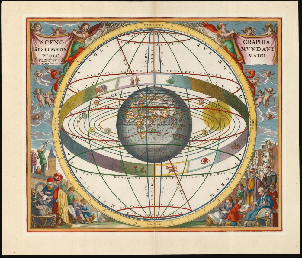
Scenographia Systematis Mundani Ptolemaici.
1708 (undated) 17 x 20 in (43.18 x 50.8 cm)
1708 (undated) 17 x 20 in (43.18 x 50.8 cm)
Description
This beautiful work is Andreas Cellarius' celestial chart, in its 1708 Valk and Schenk edition, illustrating the geocentric solar system theorized by the 2nd-century astronomer Claudius Ptolemy. One of Cellarius' most visually engaging celestial charts, it centers on a beautifully engraved hemisphere and depicts the orbits around it of the Moon, Mercury, Venus, the Sun, Mars, Jupiter, and Saturn. Surrounding the orbiting planets is the celestial sphere, divided into circles. Cellarius' lush, baroque presentation frames the chart with a sky filled with putti while on the ground, scholars, astronomers, and their students measure the sky and confer over books and globes.
Lavish Engraving
This is among the most visually engaging of Cellarius' celestial charts: surrounding the globe, planets, and the sun is a stylized armillary sphere, upon which are visible seven of the 12 signs of the Zodiac with their symbols: Taurus, Gemini, Cancer, Capricorn, Sagittarius, Scorpio, and Libra.One of Four Models
Cellarius' Harmonia Macrocosmica contained diagrams illustrating the conflicting models of the solar system in play during the 17th century. It includes not only the most modern theories of the solar system but also historical ones. A classical model of the Solar System identified each of the planets with its corresponding classical deity; the present one presented the 2nd-century model of Ptolemy. One explained the Copernican Sun-centered system, and Tycho Brahe's compromise model was also included.Dividing the Celestial Sphere
The whole of the Solar System is framed with an illustration of the concept of the celestial sphere and its primary divisions, or circles. This was a primary astronomical concept. The oldest branch of astronomy - spherical or positional astronomy - was based on the observation of the apparent movement of objects over time in relation to the Earth. The celestial sphere - an abstract sphere with the Earth at its center - was a conceptual tool that allowed astronomers to divide the sky into coordinates analogous to how geographers divided the globe (much of the terminology is the same). While positional astronomy was applied to both religion and astrology in antiquity, it retained utility for both timekeeping and navigation. So Cellarius' chart here was not a portrayal of an antiquated system of astronomical thought but rather described essential terms useful to any astronomer, whether they were applying them to the ancient astronomy of Ptolemy or the modern models of Tycho Brahe or Copernicus.A State-of-the-Art Depiction of the Globe
The diagram surrounds a depiction of the globe that reflects the current geographical knowledge when the chart was engraved. The globe's positioning focuses on the old world: Europe, Africa, and Asia. To the east, the islands of the Pacific are just visible but are cast in shadow; the Americas do not appear. The imagined Terra Australis Incognita can be seen at the South Pole. It does not seem to be coincidental that the part of the world depicted on the globe includes all of what was known to Claudius Ptolemy in the 2nd-century.Publication History and Census
This engraving was executed for Jan Jansson, who in 1660 first published Cellarius' Harmonia Macrocosmica. Jansson produced two editions of the book in 1660 and 1661; these editions are distinguishable by the plate numbers engraved for the 1661 edition. Amsterdam publishers Gerard Valk and Pieter Schenk acquired the plates and republished Cellarius' work in 1708, having added their own imprint and privilege to the plates. Separate examples of Cellarius' charts appear on the market from time to time. We see eight examples of this plate listed in OCLC, five of which correspond to this 1708 edition.CartographerS
Andreas Cellarius (1596 - 1665) was a Dutch-German cartographer, mathematician, and astronomer. He was born in Neuhausen (now a part of Worms), and was educated in Heidelberg. Cellarius, being Protestant, may have left Heidelberg in 1618, at the onset of the Thirty Years' War, or slightly later, in 1622, when the city fell to Catholics. His activities are unclear at this time but based on his later works it is conjectured he spent time in Poland where he may have taken work as a military engineer. In 1625. he married Catharina Eltemans in Amsterdam, where he taught Latin. After a brief stay in The Hague, the family moved to Hoorn. From 1637 until his death he was rector of the Hoorn Latin School. Today Cellarius is best known for his Harmonia Macrocosmica of 1660, a major celestial atlas, published in Amsterdam by Johannes Janssonius. More by this mapmaker...
Gerard Valk (September 30, 1652 - October 21, 1726) (aka. Valck, Walck, Valcke), was a Dutch engraver, globe maker, and map publisher active in Amsterdam in the latter half of the 17th century and early 18th century. Valk was born in Amsterdam where his father, Leendert Gerritsz, was a silversmith. He studied mathematics, navigation, and cartography under Pieter Maasz Smit. Valk and moved to London in 1673, where he studied engraving under Abraham Blooteling (or Bloteling) (1634 - 1690), whose sister he married, and later worked for the map sellers Christopher Browne and David Loggan. Valke and Blooteling returned to Amsterdam in 1680 and applied for a 15-year privilege, a kind of early copyright, from the States General, which was granted in 1684. In 1687, he established his own firm in Amsterdam in partnership with Petrus (Pieter) Schenk, who had just married his sister, Agata. They published under the imprint of Valk and Schenk. Also, curiously in the same year Valk acquired the home of Jochem Bormeester, also engraver and son-in-law of art dealer Clement De Jonghe. Initially Valk and Schenk focused on maps and atlases, acquiring the map plates of Jodocus Hondius and Jan Jansson in 1694. Later, in 1701 they moved into the former Hendrick Hondius (the younger) offices where they began producing globes. Valk and Schenk soon acquired the reputation of producing the finest globes in the Netherlands, a business on which they held a near monopoly for nearly 50 years. In 1702, Valk joined the Bookseller's Guild of which he was promptly elected head. Around the same time, Gerard introduced his son, Leonard, who was married to Maria Schenk, to the business. Leonard spearheaded the acquisition of the map plates of Frederick de Wit in 1709. Nonetheless, Leonard was nowhere near as sophisticated a cartographer or businessman as his father and ultimately, through neglect, lost much the firm's prestige. After his death, the firm was taken over by his widow Maria. Learn More...
Petrus Schenk (Pieter Schenck) the Elder (December 26, 1660 - 1711) was a Dutch engraver, globe maker, and map publisher active in Amsterdam and Leipzig in the latter half of the 17th century. Schenk, was born in Elberfield, Germany. He moved in Amsterdam in 1675, becoming the apprentice to Gerard Valk (Valck). In 1687, Schenk married Agatha Valk, Gerard Valk's sister and went into partnership with his brother-in-law under the imprint of 'Valk and Schenk'. Initially they focused on maps and atlases, acquiring the map plates of Jan Jansson and Jodocus Hondius in 1694. Later, in 1701 they moved into the former Hondius offices where they began producing globes. Valk and Schenk quickly became known for producing the best globes in the Netherlands, a business on which they held a near monopoly for nearly 50 years. Schenk's three sons, Pieter Schenk the Younger, Jan Schenk, and Leonard Schenk, all became engravers in their own right. Pieter Schenk the Younger inherited the business and ran his father's shop in Leipzig. His daughter, Maria Schenk, married Leonard Valk, the son of Gerard Valk, and continued to run the Valk and Schenk map engraving workshop in Amsterdam. Learn More...
Source
Cellarius, A., Atlas Coelestis seu Harmonia Macrocosmica, (Amsterdam: Valk and Schenk) 1708.
The Atlas Coelestis; Seu Harmonia Macrocosmica is an important celestial atlas by Andreas Cellarius first published in Amsterdam by Jan Jansson in 1660. Not only is this the only celestial atlas published in Amsterdam before the 19th century, it is also the most decorative celestial atlas ever produced. The atlas was lavishly illustrated in baroque ethic and contained 29 extraordinary charts. The first 21 constitute a historical survey of cosmological theories, illustrating the motions of the sun and planets according to Claudius Ptolemy, Nicolaus Copernicus, and Tycho Brahe. The subsequent 8 plates are constellation and planetary charts. Although originally conceived of as a two volume set, the second volume never materialized. Despite criticism by prominent contemporary astronomers the first volume proved immensely popular and went through three printings, 1600, 1601, and 1666. In 1694 the Jansson plates were sold to Gerard Valk and Petrus Schenk who produced a similarly lavish edition in 1708.
Condition
Very good. One marginal mend well away from printed image, else excellent.
References
OCLC 866805370.