This item has been sold, but you can get on the Waitlist to be notified if another example becomes available, or purchase a digital scan.
1708 Cellarius / Valk and Schenk Celestial Map according to Ptolemy
PlanispherePtolemy-cellariusvalk-1708$3,000.00

Title
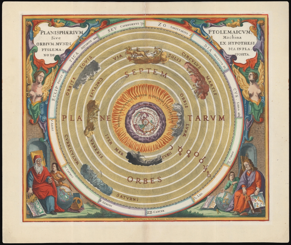
Planisphaerium Ptolemaicum, sive Machina Orbium Mundi Ex Hypothesi Ptolemaica in Plano Disposita.
1708 (undated) 17.25 x 20.75 in (43.815 x 52.705 cm)
1708 (undated) 17.25 x 20.75 in (43.815 x 52.705 cm)
Description
This beautiful work is Andreas Cellarius' celestial chart, in its 1708 Valk and Schenk edition, illustrating the geocentric solar system imagined by Claudius Ptolemy in the 2nd century, and which remained the standard model of the universe until the 16th century and the discoveries of Nicolas Copernicus. It is among the most beautiful depictions of the Earth-centered solar system produced in the 17th century.
Flanking the chart, below the cartouches, are a pair of voluptuous winged busts, perhaps intended to invoke sculpture of the classical period with which Ptolemy's astronomy was contemporary. Two scholars are seated in the lower corners - tentatively identified as Ptolemy himself at the right and Aristotle of Stagira at the left - each surrounded by geographers' books, globes, and instruments. Both attend to young students, sharing their antiquated knowledge. In sharp contrast with the polar projection on the chart itself, the maps and globes cluttering the astronomer's studies do not appear to depict anywhere in particular: if anything, they communicate to the reader that their geography is, at best, wrong.
A Closer Look
At the center of the chart is the Earth, depicted in a north polar projection. It is situated within an elemental realm - 'The world under the moon comprising the four elements'. This is represented by the Earth and surrounding circles of clouds and fire. Around this focal point are the concentric circular orbits of the moon, Mercury, and Venus; beyond this, the Sun in itsorbit, followed by Mars, Jupiter, and Saturn. Each planet is depicted not as a sphere but as a chariot driven by its respective classical deity. Thus, the Ptolemaic model is expressed not in the context of scientific observation but shrouded in myth. Bordering the chart are the twelve signs of the Zodiac, each with its astrological symbol.Flanking the chart, below the cartouches, are a pair of voluptuous winged busts, perhaps intended to invoke sculpture of the classical period with which Ptolemy's astronomy was contemporary. Two scholars are seated in the lower corners - tentatively identified as Ptolemy himself at the right and Aristotle of Stagira at the left - each surrounded by geographers' books, globes, and instruments. Both attend to young students, sharing their antiquated knowledge. In sharp contrast with the polar projection on the chart itself, the maps and globes cluttering the astronomer's studies do not appear to depict anywhere in particular: if anything, they communicate to the reader that their geography is, at best, wrong.
One of Four Models
Cellarius' Harmonia Macrocosmica contained diagrams illustrating the conflicting models of the Solar System in play during the 17th century. It includes not only the most modern theories of the Solar System but also historical ones. A classical model of the Solar System identified each of the planets with its corresponding classical deity; another presented the 2nd-century model of Ptolemy (the present work). One explained the Copernican Sun-centered system. The final is Tycho Brahe's compromise model.Publication History and Census
This engraving was executed for Jan Jansson, who in 1660 first published Cellarius' Harmonia Macrocosmica. Jansson produced two editions of the book in 1660 and 1661, which are distinguishable by the plate numbers engraved for the 1661 edition. Amsterdam publishers Gerard Valk and Pieter Schenk acquired the plates and republished Cellarius' work in 1708, having added their own imprint and privilege to the plates. Separate examples of Cellarius' charts appear on the market from time to time. We see ten examples of this plate listed in OCLC, five of which correspond to this 1708 edition.CartographerS
Andreas Cellarius (1596 - 1665) was a Dutch-German cartographer, mathematician, and astronomer. He was born in Neuhausen (now a part of Worms), and was educated in Heidelberg. Cellarius, being Protestant, may have left Heidelberg in 1618, at the onset of the Thirty Years' War, or slightly later, in 1622, when the city fell to Catholics. His activities are unclear at this time but based on his later works it is conjectured he spent time in Poland where he may have taken work as a military engineer. In 1625. he married Catharina Eltemans in Amsterdam, where he taught Latin. After a brief stay in The Hague, the family moved to Hoorn. From 1637 until his death he was rector of the Hoorn Latin School. Today Cellarius is best known for his Harmonia Macrocosmica of 1660, a major celestial atlas, published in Amsterdam by Johannes Janssonius. More by this mapmaker...
Gerard Valk (September 30, 1652 - October 21, 1726) (aka. Valck, Walck, Valcke), was a Dutch engraver, globe maker, and map publisher active in Amsterdam in the latter half of the 17th century and early 18th century. Valk was born in Amsterdam where his father, Leendert Gerritsz, was a silversmith. He studied mathematics, navigation, and cartography under Pieter Maasz Smit. Valk and moved to London in 1673, where he studied engraving under Abraham Blooteling (or Bloteling) (1634 - 1690), whose sister he married, and later worked for the map sellers Christopher Browne and David Loggan. Valke and Blooteling returned to Amsterdam in 1680 and applied for a 15-year privilege, a kind of early copyright, from the States General, which was granted in 1684. In 1687, he established his own firm in Amsterdam in partnership with Petrus (Pieter) Schenk, who had just married his sister, Agata. They published under the imprint of Valk and Schenk. Also, curiously in the same year Valk acquired the home of Jochem Bormeester, also engraver and son-in-law of art dealer Clement De Jonghe. Initially Valk and Schenk focused on maps and atlases, acquiring the map plates of Jodocus Hondius and Jan Jansson in 1694. Later, in 1701 they moved into the former Hendrick Hondius (the younger) offices where they began producing globes. Valk and Schenk soon acquired the reputation of producing the finest globes in the Netherlands, a business on which they held a near monopoly for nearly 50 years. In 1702, Valk joined the Bookseller's Guild of which he was promptly elected head. Around the same time, Gerard introduced his son, Leonard, who was married to Maria Schenk, to the business. Leonard spearheaded the acquisition of the map plates of Frederick de Wit in 1709. Nonetheless, Leonard was nowhere near as sophisticated a cartographer or businessman as his father and ultimately, through neglect, lost much the firm's prestige. After his death, the firm was taken over by his widow Maria. Learn More...
Petrus Schenk (Pieter Schenck) the Elder (December 26, 1660 - 1711) was a Dutch engraver, globe maker, and map publisher active in Amsterdam and Leipzig in the latter half of the 17th century. Schenk, was born in Elberfield, Germany. He moved in Amsterdam in 1675, becoming the apprentice to Gerard Valk (Valck). In 1687, Schenk married Agatha Valk, Gerard Valk's sister and went into partnership with his brother-in-law under the imprint of 'Valk and Schenk'. Initially they focused on maps and atlases, acquiring the map plates of Jan Jansson and Jodocus Hondius in 1694. Later, in 1701 they moved into the former Hondius offices where they began producing globes. Valk and Schenk quickly became known for producing the best globes in the Netherlands, a business on which they held a near monopoly for nearly 50 years. Schenk's three sons, Pieter Schenk the Younger, Jan Schenk, and Leonard Schenk, all became engravers in their own right. Pieter Schenk the Younger inherited the business and ran his father's shop in Leipzig. His daughter, Maria Schenk, married Leonard Valk, the son of Gerard Valk, and continued to run the Valk and Schenk map engraving workshop in Amsterdam. Learn More...
Source
Cellarius, A., Atlas Coelestis seu Harmonia Macrocosmica, (Amsterdam: Valk and Schenk) 1708.
The Atlas Coelestis; Seu Harmonia Macrocosmica is an important celestial atlas by Andreas Cellarius first published in Amsterdam by Jan Jansson in 1660. Not only is this the only celestial atlas published in Amsterdam before the 19th century, it is also the most decorative celestial atlas ever produced. The atlas was lavishly illustrated in baroque ethic and contained 29 extraordinary charts. The first 21 constitute a historical survey of cosmological theories, illustrating the motions of the sun and planets according to Claudius Ptolemy, Nicolaus Copernicus, and Tycho Brahe. The subsequent 8 plates are constellation and planetary charts. Although originally conceived of as a two volume set, the second volume never materialized. Despite criticism by prominent contemporary astronomers the first volume proved immensely popular and went through three printings, 1600, 1601, and 1666. In 1694 the Jansson plates were sold to Gerard Valk and Petrus Schenk who produced a similarly lavish edition in 1708.
Condition
Excellent. Marginal mend at bottom centerfold not impacting printed image, else a fine example. Beautiful hand color, heightened with gold.
References
OCLC 866805332.