
Montanus, Arnoldus

Arnoldus Montanus (c. 1625 - 1683) was a Dutch scholar, publisher, schoolmaster and author active in Amsterdam during the latter half of the 17th century. Montanus is a Latinized form of van den Berg or van Bergen. He studied theology at Leiden University and was ordained a minister in 1653. In 1667 he became headmaster of the Latin School of Schoonhoven, where he died in 1683. Most of Montanus's work was published in conjunction with engraver Jacob van Meurs and focused on travel narratives to Asia and the Americas. His most famous book, De Nieuwe en Onbekende Weereld, contains what is arguably the first view of New York City, the New Amsterdam. His other works offer up some of the earliest known descriptions of China and Japan. Much of Montanus' work was translated and published in English by John Ogilby.
Early French Settlement in Florida.
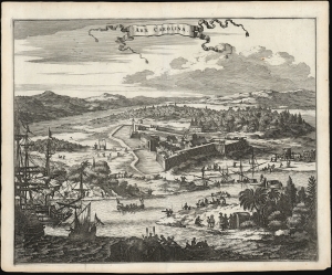
Arx Carolina.
$750.00
Acquire
- Digital Map Information
- Suitable for large format printing
- File Size: 13.88 MB
- File Type: ZIP / TIFF
- ICC color profile embedded
- Delivered instantly via download link
This is a beautifully realized 1671 Arnoldus Montanus view of Arx Carolina, or Fort Caroline, situated on the present-day St. John's River, in the vicinity of Jacksonville, Florida. It portrays the French Huguenot fort, imagined as it was before its 1565 destruction by the Spanish. (more details)
The Dutch Sack Olinda.
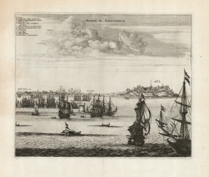
Olinda de Phernambuco.
$350.00
Acquire
- Digital Map Information
- Suitable for large format printing
- DPI: 600
- File Size: 32.76 MB
- File Type: ZIP / TIFF
- ICC color profile embedded
- Delivered instantly via download link
This is a 1671 Arnold Montanus view of the 1630 Dutch attack and capture of Olinda, the Portuguese capital of the captaincy of Pernambuco in Brazil. This establishment of a Dutch foothold in Brazil represented a high point in the globally fought Dutch-Portuguese War (1602 - 1654). The Dutch victory was short-lived as Brazilian 'New Holland' would only last until 1654. Nevertheless, the event was celebrated in Dutch histories, hence Montanus' inclusion of this image in his De Nieuwe en Onbekende Weereld and its concurrent printing in Ogilby's America. (more details)
Oldest European City in the United States.
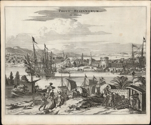
Pagus Hispanorum in Florida.
$850.00
Acquire
- Digital Map Information
- Suitable for large format printing
- File Size: 11.4 MB
- File Type: ZIP / TIFF
- ICC color profile embedded
- Delivered instantly via download link
This is a beautifully realized Arnoldus Montanus/John Ogilby view of the Spanish settlement of St. Augustine, Florida, the oldest European city within the bounds of what would be the United States. St. Augustine was founded by Pedro Menendez in 1565 to protect the northernmost frontier of the Spanish Empire on America's east coast and to project Spanish power over the trade route passing from the Gulf of Mexico through the passage between Florida and the Bahamas. (more details)
Among the First Views of Colonial Mexico City.
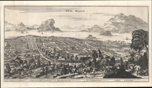
Nova Mexico.
$600.00
Acquire
- Digital Map Information
- Suitable for large format printing
- File Size: 22.63 MB
- File Type: ZIP / TIFF
- ICC color profile embedded
- Delivered instantly via download link
A rare and impressive view of Mexico City from John Ogilby's 1671 America. This is one of the first representations of Mexico City as a Spanish colonial center. (more details)
Key Fort in Dutch Brazil.
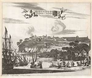
Castrum Mauritij ad Ripam Fluminis S. Francisci.
$475.00
Acquire
- Digital Map Information
- Suitable for large format printing
- DPI: 600
- File Size: 26.03 MB
- File Type: ZIP / TIFF
- ICC color profile embedded
- Delivered instantly via download link
This is a 1673 Arnold Montanus view of the Dutch defenses at Fort Maurits, controlling access to Brazil's Rio São Francisco. It shows the fort atop the bluffs overlooking the São Francisco. On the shore, traders from sailing ships and river sloops meet sugar plantationers and their slaves hauling barrels of sugar or molasses. (more details)