This item has been sold, but you can get on the Waitlist to be notified if another example becomes available, or purchase a digital scan.
1673 Montanus of Guiana, Venezuela and El Dorado
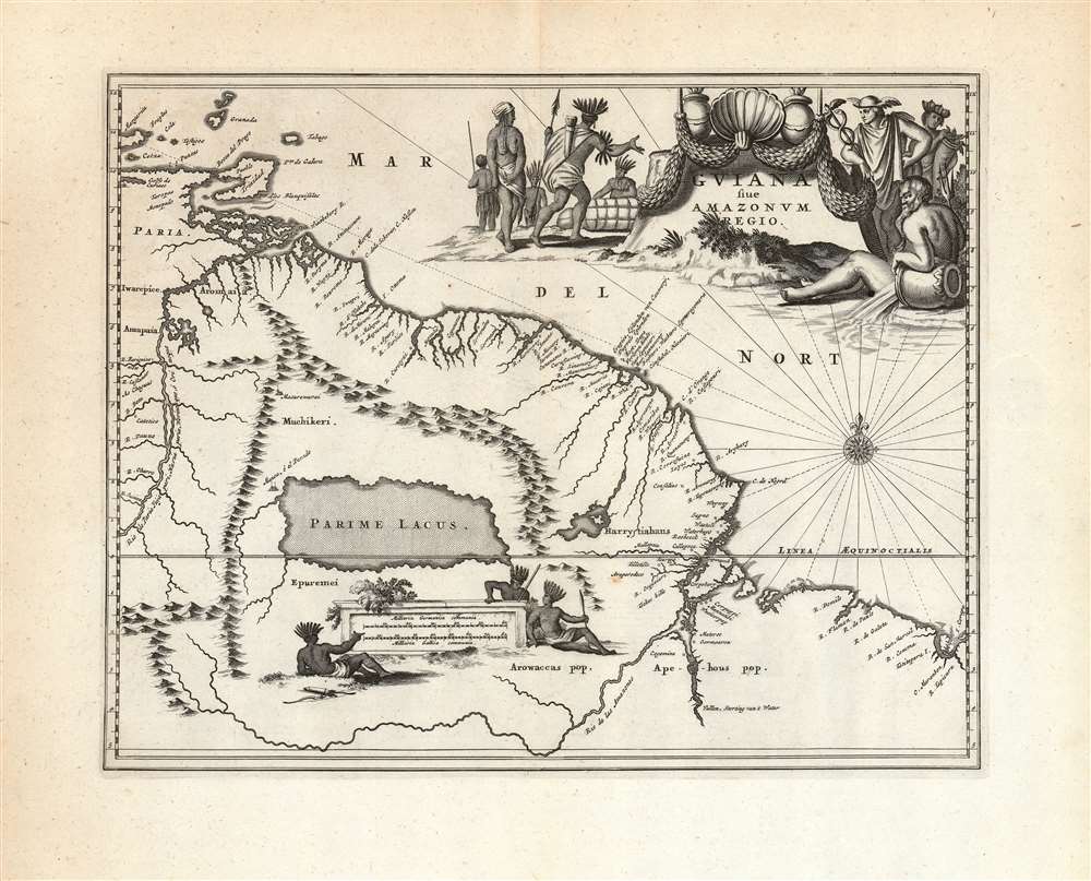
Guiana-montanus-1673$175.00

Title
Guiana sive Amazonum Regio.
1673 (undated) 11.25 x 14.25 in (28.575 x 36.195 cm) 1 : 6900000
1673 (undated) 11.25 x 14.25 in (28.575 x 36.195 cm) 1 : 6900000
Description
This beautiful engraving is a 1673 Arnold Montanus map of the northwestern parts of South America, including Lake Parima (Parime Lacus), revealing the hoped-for route to El Dorado. Coverage embraces from Isla Margarita and the Orinoco Delta eastward as far as Tampico and southwards as far as the Amazon River. Geographically, the map is a faithful copy of a map of the same title engraved by Jodocus Hondius Jr. in 1629, and published by the Blaeu and Hondius firms throughout the 17th century. This whole lineage of maps derives from Hessel Gerritz' seminal Guaiana ofte de Provincien tusschen Rio de las Amazonas ende Rio de Yuiapari ofte Orinoque, a map based equally on Gerritz' own travels to the West Indies and the firm belief of travelers and geographers alike in the existence of El Dorado. This example appeared in Montanus' 1673 Unbekannte Neue Welt, having been engraved by Montanus for John Ogilby's America in 1671 (there is no alteration to the plate between these two issues, and no clear distinction to be made between them).
El Dorado?
This region of South America generated considerable European interest in the early 17th century following the publication of Sir Walter Raleigh's fascinating Discovery of the Large, Rich, and Beautiful EMPIRE Of GUIANA. Raleigh's expedition traveled down the Orinoco River in search of the Kingdom of El Dorado. Today we know that El Dorado did not exist but was rather an amalgam of very real tribal traditions and the European lust for gold. Nonetheless, in the 16th century, tales of El Dorado were common conversation along the port cities of the Spanish Main. Having explored a considerable distance down the Orinoco, Raleigh's expedition found itself mired in a remote tribal village at the onset of the rainy season. While waiting for an opportunity to return north, a trading delegation arrived. At this time the dominate trading empire in the Amazon were the Manoa, who, though based near modern day Manaus, pursued trade routes from the foothills of the Andes to the Amazon and Orinoco Deltas. While the rainy season prevented Raleigh from moving forward, for the Manoa it had the opposite effect. The heavy rains inundated the vast Parima flood plain creating a great inland sea, consequently opening an important trade connection between the Amazon and Orinoco Rivers. When the Manoa arrived, Raleigh and his men noticed that they had various golden trinkets for sale. This was apparently enough for Raleigh to deduce that they must indeed be from the hidden kingdom of El Dorado. When Raleigh asked where the traders came from, the locals, with no common language with which to engage Raleigh, could only explain that they traveled across a great water and were from Manoa. Raleigh's presumptuous narrative inspired many early cartographers to map this massive lake, with the city of El Dorado or Manoa on its shores, in the unexplored lands between the Orinoco and Amazon River basins.Evocative and Decorative
Despite its execution in a smaller folio format than the Blaeu and Hondius maps, Montanus' iteration of the Gerritz map displays more decorative flourish. Below the expanse of Parime Lacus, three native warriors rest around a plinth displaying the map scales. In the upper right is an elaborate allegorical title cartouche: natives gather bundles of goods and present them to Hermese (he with the Caduceus and winged helmet, patron of communication and commerce.) Behind this figure, and in shadow, is a version of the goddess of Fortune, in a nautical aspect with a crown made of ships' prows. She contemplatively holds in her arms a cornucopia, signifying the prosperity to be hoped for in the commercial domination of the sea. Seated before the cartouche is a deification of the rivers, probably specifically the Amazon, signified by the old man's ever-overflowing water jar.Publication History and Census
This view was engraved by Montanus for inclusion in John Ogilby's 1671 America and was used again by Montanus for his Unbekannte Neue Welt in 1673. Thirteen examples of Montanus' book are cataloged by institutional collections. Despite only five separate examples of this map being listed in OCLC, they appear on the market from time to time.CartographerS
Arnoldus Montanus (c. 1625 - 1683) was a Dutch scholar, publisher, schoolmaster and author active in Amsterdam during the latter half of the 17th century. Montanus is a Latinized form of van den Berg or van Bergen. He studied theology at Leiden University and was ordained a minister in 1653. In 1667 he became headmaster of the Latin School of Schoonhoven, where he died in 1683. Most of Montanus's work was published in conjunction with engraver Jacob van Meurs and focused on travel narratives to Asia and the Americas. His most famous book, De Nieuwe en Onbekende Weereld, contains what is arguably the first view of New York City, the New Amsterdam. His other works offer up some of the earliest known descriptions of China and Japan. Much of Montanus' work was translated and published in English by John Ogilby. More by this mapmaker...
Jodocus Hondius II (1594 – 1629) was a Dutch engraver, cartographer and publisher. The elder son of the cartographer Jodocus Hondius, Jodocus took over the business after father died in 1612, co-running the business with his brother Henricus II. He was an accomplished engraver, to the extent that upon his death Willem Blaeu would purchase thirty-four of Hondius' plates to be included in his new atlases. Learn More...
Hessel Gerritsz (1581 – September 4, 1632) was a Dutch engraver, cartographer, and publisher active in Amsterdam during the late 16th and early 17th centuries, among the most preeminent Dutch geographers of the 17th century. He was born in Assum, a town in northern Holland in 1581. As a young man he relocated to Alkmaar to accept an apprenticeship with Willem Jansz Blaeu (1571-1638). He followed Blaeu to Amsterdam shortly afterwards. By 1610 he has his own press, but remained close to Blaeu, who published many of his maps. In October of 1617 he was appointed the first official cartographer of the Vereenigde Oost-Indische Compagnie (Dutch East Indian Company) or VOC. This strategic position offered him unprecedented access to the most advanced and far-reaching cartographic data of the Dutch Golden Age. Unlike many cartographers of his period, Gerritsz was more than a simple scholar and showed a true fascination with the world and eagerness to learn more of the world he was mapping in a practical manner. In 1628 he joined a voyage to the New World which resulted in the production of his seminal maps, published by Joannes de Laet in his 1630 Beschrijvinghe van West-Indien; these would be aggressively copied by both the Blaeu and Hondius houses, and long represented the standard followed in the mapping of the new world. Among his other prominent works are a world map of 1612, a 1613 map of Russia by the brilliant Russian prince Fyodor II Borisovich Godunov (1589 – 1605), a 1618 map of the pacific that includes the first mapping of Australia, and an influential 1630 map of Florida. Gerritsz died in 1632. His position with the VOC, along with many of his printing plates, were taken over by Willem Janszoon Blaeu. Learn More...
Source
Montanus, A., Die Nieuwe en Onbekende Weereld, (Amsterdam) 1673.
Condition
Very good. Some wear at centerfold with no loss; else excellent with a sharp strike and generous margins.
References
OCLC 644451615.