This item has been sold, but you can get on the Waitlist to be notified if another example becomes available, or purchase a digital scan.
1671 Montanus Map of Brazil
Brazil-montanus-1671$187.50

Title
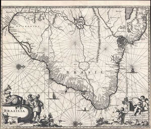
Brasilia.
1671 (undated) 11.5 x 14 in (29.21 x 35.56 cm) 1 : 13850000
1671 (undated) 11.5 x 14 in (29.21 x 35.56 cm) 1 : 13850000
Description
This is a 1671 Arnoldus Montanus map of Brazil. Oriented toward the west, the map depicts the region from the Rio de la Plata to Guiana and the Atlantic Ocean and from two mythical lakes (Lake Parima and Lake Xarayes) to the Atlantic Ocean. As was common for maps of South America from this time, the coast is mapped in detail, with myriad labeled locations along the Brazilian coast and numerous small rivers emptying into the ocean. However, unlike many other contemporary maps of this region, and innumerable others that came after, Montanus does not attempt to connect the Paraguay River with the Amazon. Instead, he has depicted an apocryphal mountain range across northern Brazil, effectively separating the two major rivers.
The Laguna de Xarayes
The mythical Laguna de Xarayes, labeled as the Puerto de los Reyes (The Doorway of the Kings) is illustrated here as the northern terminus, or source, of the Paraguay River. The Xarayes, a corruption of 'Xaraies' meaning 'Masters of the River', were an indigenous people occupying what are today parts of Brazil's Matte Grosso and the Pantanal. When Spanish and Portuguese explorers first navigated up the Paraguay River, as always in search of El Dorado, they encountered the vast Pantanal flood plain at the height of its annual inundation. Understandably misinterpreting the flood plain as a gigantic inland sea, they named it after the local inhabitants, the Xaraies. The Laguna de los Xarayes almost immediately began to appear on early maps of the region and, at the same time, to take on a legendary quality. Later missionaries and chroniclers, particularly Díaz de Guzman, imagined an island in this lake and curiously identified it as an 'Island of Paradise,'
Lake Parima
The mythical Lake Parima, depicted in Guiana, is associated with the English adventurer Sir Walter Raleigh's search for El Dorado. Believing El Dorado to lie in the northern part of the Amazon, Raleigh sailed down the Orinoco River just before the onset of the rainy season. Reaching a remote tribal village, Raleigh noted canoes arriving bearing gold, silver, and other treasures. Asked where the gold came from, the natives replied, 'Manoa', the term for the tribe to which the river traders belonged. Manoa, the natives claimed, could be reached following a long river voyage southward to a Great Lake, called Parima. Raleigh and his associates immediately associated Manoa and Lake Parima with the golden kingdom of El Dorado, though they never visited the city or lake. Subsequent maps, including this one, mapped El Dorado and Lake Parima in this location for several hundred years. Both Raleigh and the natives were describing an actual event known to occur annually in the region. Rains would annually swell the Amazon and Orinoco river systems creating a linkage in the Rupununu flood plain, which, during heavy rains, can resemble a massive lake. The Manoa were a large and populous trading nation active in pre-colonial days whose vast empire, based in the Amazon Basin, extended form the Andes to the Orinoco. Sadly, the Manoa and many of the other populous South American indigenous nations noted by the earliest explores to the region vanished, brought low by European epidemics.
Featuring a decorative title cartouche in the lower left corner, and a scale cartouche in the lower right corner, this map was published by Montanus in his Die Nieuwe en Onbekende Weereld in 1671. Exquisitely engraved and a beautifully clean impression, this map would make a wonderful addition to any collection.
The Laguna de Xarayes
The mythical Laguna de Xarayes, labeled as the Puerto de los Reyes (The Doorway of the Kings) is illustrated here as the northern terminus, or source, of the Paraguay River. The Xarayes, a corruption of 'Xaraies' meaning 'Masters of the River', were an indigenous people occupying what are today parts of Brazil's Matte Grosso and the Pantanal. When Spanish and Portuguese explorers first navigated up the Paraguay River, as always in search of El Dorado, they encountered the vast Pantanal flood plain at the height of its annual inundation. Understandably misinterpreting the flood plain as a gigantic inland sea, they named it after the local inhabitants, the Xaraies. The Laguna de los Xarayes almost immediately began to appear on early maps of the region and, at the same time, to take on a legendary quality. Later missionaries and chroniclers, particularly Díaz de Guzman, imagined an island in this lake and curiously identified it as an 'Island of Paradise,'
...an island [of the Paraguay River] more than ten leagues [56 km] long, two or three [11-16 km] wide. A very mild land rich in a thousand types of wild fruit, among them grapes, pears and olives: the Indians created plantations throughout, and throughout the year sow and reap with no difference in winter or summer, ... the Indians of that island are of good will and are friends to the Spaniards; Orejón they call them, and they have their ears pierced with wheels of wood ... which occupy the entire hole. They live in round houses, not as a village, but each apart though keep up with each other in much peace and friendship. They called of old this island Land of Paradise for its abundance and wonderful qualities.
Lake Parima
The mythical Lake Parima, depicted in Guiana, is associated with the English adventurer Sir Walter Raleigh's search for El Dorado. Believing El Dorado to lie in the northern part of the Amazon, Raleigh sailed down the Orinoco River just before the onset of the rainy season. Reaching a remote tribal village, Raleigh noted canoes arriving bearing gold, silver, and other treasures. Asked where the gold came from, the natives replied, 'Manoa', the term for the tribe to which the river traders belonged. Manoa, the natives claimed, could be reached following a long river voyage southward to a Great Lake, called Parima. Raleigh and his associates immediately associated Manoa and Lake Parima with the golden kingdom of El Dorado, though they never visited the city or lake. Subsequent maps, including this one, mapped El Dorado and Lake Parima in this location for several hundred years. Both Raleigh and the natives were describing an actual event known to occur annually in the region. Rains would annually swell the Amazon and Orinoco river systems creating a linkage in the Rupununu flood plain, which, during heavy rains, can resemble a massive lake. The Manoa were a large and populous trading nation active in pre-colonial days whose vast empire, based in the Amazon Basin, extended form the Andes to the Orinoco. Sadly, the Manoa and many of the other populous South American indigenous nations noted by the earliest explores to the region vanished, brought low by European epidemics.
Featuring a decorative title cartouche in the lower left corner, and a scale cartouche in the lower right corner, this map was published by Montanus in his Die Nieuwe en Onbekende Weereld in 1671. Exquisitely engraved and a beautifully clean impression, this map would make a wonderful addition to any collection.
Cartographer
Arnoldus Montanus (c. 1625 - 1683) was a Dutch scholar, publisher, schoolmaster and author active in Amsterdam during the latter half of the 17th century. Montanus is a Latinized form of van den Berg or van Bergen. He studied theology at Leiden University and was ordained a minister in 1653. In 1667 he became headmaster of the Latin School of Schoonhoven, where he died in 1683. Most of Montanus's work was published in conjunction with engraver Jacob van Meurs and focused on travel narratives to Asia and the Americas. His most famous book, De Nieuwe en Onbekende Weereld, contains what is arguably the first view of New York City, the New Amsterdam. His other works offer up some of the earliest known descriptions of China and Japan. Much of Montanus' work was translated and published in English by John Ogilby. More by this mapmaker...
Source
Montanus, A., Die Nieuwe en Onbekende Weereld, (Amsterdam) 1671.
Condition
Very good. Close margins, trimmed to neat line. Even overall toning. Blank on verso.
References
OCLC 46662922.