
Palmer, William I. (I. Palmer, W. Palmer)

William I. Palmer (March 4, 1739 - November 1812) was a British engraver, gun engraver, mapmaker, and globe maker active in London in the late 18th century. Palmer was born in London, the son of William Palmer Sr., a pants maker. He was apprenticed to the goldsmith and engraver John Pine in 1753. When Pine died in 1757, his apprenticeship was transferred to the prominent engraver Richard William Seale (1703 - 1762). Palmer flourished under Seale's guidance, marring Mary Seale, his master's youngest daughter in 1762. In that same year, he took over Seale's workshop, becoming a prominent engraver in his own right. From 1780 to 1790 he partnered with the globe maker John Newton (1758 - 1844). After 1790 he separated from Newton, partnered with his son, John Palmer, establishing the imprint of William and John Palmer. He notable engraved some of the charts for the official account of Cook's voyages, as well as charts for William Faden, Robert Sayer, Alexander Dalrymple, Laurie and Whittle, and Robert Wilkinson. Palmer is also known in gun collecting and furniture circles for his fine metal engraving work, which can be seen on John Channon furniture, among others.
Palmer, William I. is also known as: I. Palmer, W. Palmer
Legendary 'Lost' Cook Chart.
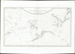
Chart of the N.W. Coast of America and the N.E. Coast of Asia, Explored in the Years 1778 and 1779.
$8,500.00
Acquire
- Digital Map Information
- Suitable for large format printing
- File Size: 17.45 MB
- File Type: ZIP / TIFF
- ICC color profile embedded
- Delivered instantly via download link
This is the suppressed 1784 first edition of Henry Roberts and Captain James Cook's legendary 'Lost Map', issued separately by London publisher William Faden. This is the first map to illustrate the discoveries of Samuel Herne on the Coppermine River. The chart was censured due to the political machinations of the powerful Hudson Bay Company, which had a sustained interest in keeping Herne's voyage secret as it disproved the notion that an inland water route might connect the Hudson Bay with the Pacific, thus threatening the HBC's stock value. (more details)
Ethan Allen's brother Ira: Mapping his way out of jail.
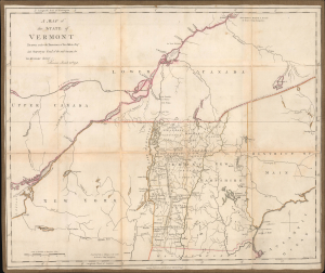
A Map of the State of Vermont Drawn under the Direction of Ira Allen Esq.
$7,500.00
Acquire
- Digital Map Information
- Suitable for large format printing
- Full resolution TIFF file
- ICC color profile embedded
- Delivered instantly via download link
A remarkable 1798 Ira Allen map of Vermont, northern New England, New York, and southern Canada, engraved in London during Allen's detention by British authorities. Although titled simply A Map of the State of Vermont, it is less a conventional state map than a calculated political and commercial argument. Allen, the younger brother of Ethan Allen, emphasizes Vermont's strategic position between the Hudson-Champlain corridor and the St. Lawrence River, illustrates his proposed canal into British Canada, and presents the young state as both the natural center of a potentially lucrative international trade network and a vulnerable frontier requiring military protection. (more details)