
Palmer, William (sold) (I. Palmer, W. Palmer)

William I. Palmer (March 4, 1739 - November 1812) was a British engraver, gun engraver, mapmaker, and globe maker active in London in the late 18th century. Palmer was born in London, the son of William Palmer Sr., a pants maker. He was apprenticed to the goldsmith and engraver John Pine in 1753. When Pine died in 1757, his apprenticeship was transferred to the prominent engraver Richard William Seale (1703 - 1762). Palmer flourished under Seale's guidance, marring Mary Seale, his master's youngest daughter in 1762. In that same year, he took over Seale's workshop, becoming a prominent engraver in his own right. From 1780 to 1790 he partnered with the globe maker John Newton (1758 - 1844). After 1790 he separated from Newton, partnered with his son, John Palmer, establishing the imprint of William and John Palmer. He notable engraved some of the charts for the official account of Cook's voyages, as well as charts for William Faden, Robert Sayer, Alexander Dalrymple, Laurie and Whittle, and Robert Wilkinson. Palmer is also known in gun collecting and furniture circles for his fine metal engraving work, which can be seen on John Channon furniture, among others.
Palmer, William (sold) is also known as: I. Palmer, W. Palmer
The first official map of Cook's voyages.
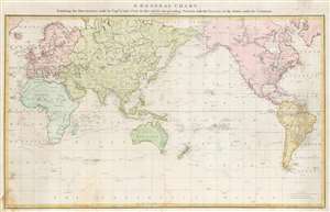
A General Chart: Exhibiting the Discoveries made by Captn. James Cook in this and his two preceding Voyages; with the Tracks of the Ships under his Command.
sold
- Digital Map Information
- Suitable for large format printing
- DPI: 600
- File Size: 28.22 MB
- File Type: ZIP / TIFF
- ICC color profile embedded
- Delivered instantly via download link
An attractive full original color example of Henry Robert's 1784 map of the world drawn to exhibit Captain James' Cook's voyages. This is the official chart of the voyages, published with the official account, and when it was issued, was the most sophisticated map of the world yet introduced, exhibiting heretofore unknown discoveries in the high arctic, and elsewhere. Coverage, as the title suggests, is expansive, underscoring the extensiveness of Cook's voyages ranging from the polar extremes to the Equator and circumnavigate the globe. The tracks of all three voyages are noted, with dating identifying important moments and annotations in Cook's journals. (more details)
The most decorative world map of the 19th century.
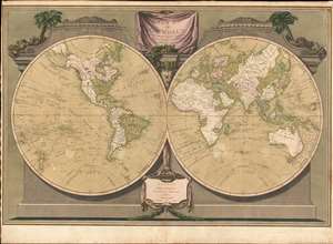
A New Map of the World, with Captain Cook's Tracks, His Discoveries and those of the Other Circumnavigators.
sold
- Digital Map Information
- Suitable for large format printing
- Full resolution TIFF file
- ICC color profile embedded
- Delivered instantly via download link
Possibly the most decorative 19th century double-hemisphere world map, this is Laurie and Whittle's New Map of the World with Captain Cook's Tracks. The map presents the eastern and western hemisphere, set in a striking architectural border with the hemispheres adorned by a pediment identifying the Old and New World. A drape-style title cartouche adorns the top of the map and is surrounded by palms trees, native costumes, and weaponry. On the map itself, the routes of Captain Cook's three voyages, as well as the routes of other circumnavigators are noted. (more details)