1784 Cook / Roberts 'Lost Cook Chart' of the North Pacific: Alaska, Siberia, Canada
LostChartCook-roberts-1784$8,500.00


Title
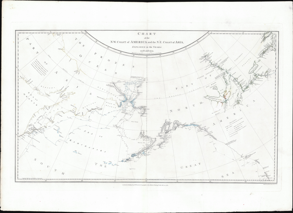
Chart of the N.W. Coast of America and the N.E. Coast of Asia, Explored in the Years 1778 and 1779.
1784 (dated) 15.5 x 26.5 in (39.37 x 67.31 cm)
1784 (dated) 15.5 x 26.5 in (39.37 x 67.31 cm)
Description
This is the suppressed 1784 first edition of Henry Roberts and Captain James Cook's legendary 'Lost Map', issued separately by London publisher William Faden. This is the first map to illustrate the discoveries of Samuel Herne on the Coppermine River. The chart was censured due to the political machinations of the powerful Hudson Bay Company, which had a sustained interest in keeping Herne's voyage secret as it disproved the notion that an inland water route might connect the Hudson Bay with the Pacific, thus threatening the HBC's stock value.
The chart was drawn by Henry Roberts, chief cartographic officer on Cook's Third Voyage. Roberts initially created the chart for the official atlas accompanying the published narrative of Cook's final expedition (A Voyage to the Pacific Ocean..., London, 1784). Due to economic pressure, political suppression, and editorial disagreements, Robert's chart was excluded from that publication. Nonetheless, the plate was acquired by William Faden and published independently - as here.
Herne, accompanied by a group of Chipewyan guides led by Matonabbee and 8 of his wives, who were used as 'beasts of burden,' traveled overland from Hudson Bay near Fort Prince of Wales (Churchill, Manitoba) to Great Slave Lake, then north along the Coppermine River to the Arctic Ocean. The expedition proved conclusively that no inland water route connected the Hudson Bay to the Pacific, an idea long promulgated by the Hudson Bay Company to pump their stock price.
In 1777, the ships visited Tonga and Tahiti before sailing north, encountering the Hawaiian Islands for the first time in January 1778. During the summer of 1778, the crew charted the American Northwest Coast, stopping at Nootka and Prince William Sounds, and exploring Cook Inlet. After a failed attempt at finding a western entrance to the hoped-for Northwest Passage, the ships moved west, passed the Aleutians, and reached the Asian coastline. They returned to Hawai'i in January 1779.
Initially welcomed at Kealakekua Bay, the crew was later met with hostility after they returned due to a damaged mast. During a dispute over a stolen boat, Cook and 4 marines were killed, along with 16 Hawaiians.
Clerke assumed command and secured Cook's remains for burial at sea. He then continued north, reading the Bering Strait before being turned back by ice floes. Clerke himself died in Kamchatka in August 1779. Command passed to John Gore, who brought the ships back to England in October 1780.
Roberts' chart includes an array of significant features absent from the official map, such as the Coppermine River, for the first time in print, and evidence negating a Northwest Passage via Hudson Bay. The map's commercial sensitivity may explain the omission, especially given the Hudson's Bay Company's interests.
The connection between Roberts' map and Faden's publication wasn't widely recognized until 1985, when the British Library acquired a proof. Faden acquired the plate from Roberts and published the map just a month after the release of the official Cook atlas. The map contains 14 Alaskan toponyms missing from the official chart, including Bald Head, Cape Denbigh, and Cape Darby in Norton Sound.
Faden released a revised edition in 1794, engraved by Louis Stanislas D'Arcy de la Rochette, incorporating more detail from Russian expeditions, whalers' reports, and George Vancouver's surveys in the Pacific Northwest.
A Closer Look
Centered loosely on the Bearing Strait, coverage embraces from the Seat of Okotsk in Siberia to Hudson Bay. The map provides a detailed view of both charted and uncharted territories along the North Pacific coasts of Asia and North America, tracking Cook's voyages from 1778 - 1779.The chart was drawn by Henry Roberts, chief cartographic officer on Cook's Third Voyage. Roberts initially created the chart for the official atlas accompanying the published narrative of Cook's final expedition (A Voyage to the Pacific Ocean..., London, 1784). Due to economic pressure, political suppression, and editorial disagreements, Robert's chart was excluded from that publication. Nonetheless, the plate was acquired by William Faden and published independently - as here.
Samuel Herne Content
Roberts' version of the map is significantly more comprehensive than the one published in the official atlas. Besides Cook's discoveries, this chart is significant as the first printed map to feature Samuel Hearne's (1745 - 1792) expedition to the Coppermine River in the Canadian Arctic. Hearne, the first European to reach the Arctic Ocean overland through Canada (1770 - 1772), documented the coastline and named the Coppermine River. While his maps and journal were not published until 1795, this map reflects information derived from a circa 1772 manuscript held by the Hudson's Bay Company.Herne, accompanied by a group of Chipewyan guides led by Matonabbee and 8 of his wives, who were used as 'beasts of burden,' traveled overland from Hudson Bay near Fort Prince of Wales (Churchill, Manitoba) to Great Slave Lake, then north along the Coppermine River to the Arctic Ocean. The expedition proved conclusively that no inland water route connected the Hudson Bay to the Pacific, an idea long promulgated by the Hudson Bay Company to pump their stock price.
Cook's Third and Final Voyage
Cook's Third Voyage focused on locating the Northwest Passage. Cook commanded the Resolution and was accompanied by Charles Clerke on the Discovery. The expedition left Plymouth in July 1776, rounded the Cape of Good Hope, and called at Tasmania and New Zealand before heading into the central Pacific.In 1777, the ships visited Tonga and Tahiti before sailing north, encountering the Hawaiian Islands for the first time in January 1778. During the summer of 1778, the crew charted the American Northwest Coast, stopping at Nootka and Prince William Sounds, and exploring Cook Inlet. After a failed attempt at finding a western entrance to the hoped-for Northwest Passage, the ships moved west, passed the Aleutians, and reached the Asian coastline. They returned to Hawai'i in January 1779.
Initially welcomed at Kealakekua Bay, the crew was later met with hostility after they returned due to a damaged mast. During a dispute over a stolen boat, Cook and 4 marines were killed, along with 16 Hawaiians.
Clerke assumed command and secured Cook's remains for burial at sea. He then continued north, reading the Bering Strait before being turned back by ice floes. Clerke himself died in Kamchatka in August 1779. Command passed to John Gore, who brought the ships back to England in October 1780.
The Lost Chart: Contravorsey and Supression
After Cook's death, the publication of the official account became contentious. Two factions emerged: the cartographers (Roberts and James King) and the institutional authorities (Sir Joseph Banks, Alexander Dalrymple, Lord Keppel, and others). Helen Wallis, in Publication of Cook's Journals: Some New Sources and Assessments, comments,The maps and engravings were a major source of disagreement between the editors and the committee whose proceedings seem to have become more arbitrary with the succession of Keppel as First Lord. Banks and Webber [the voyage artist] supervised the engraving of the drawings while Alexander Dalrymple (none other) 'at Lord Sandwich's desire,' had direction of the charts and coastal views, with the exception of the general chart. Under the sole direction of the Admiralty this was being prepared by Lieutenant Henry Roberts, who had served as master's mate in the Resolution under William Bligh.King recounted in a letter to Dr. John Douglas (July 25, 1782):
I was received coldly, perhaps owing to my having desired the engraver of the Genl. map not to proceed with it till further enquiry should be made whether the original plan of it should be altered in the way it was by Mr.Dalrymple... Sir Joseph then waited on Lord Keppel... the consequence was that his Lordship left the entire direction of the engraving of Mr. Webbers drawings as well as of the maps to him, upon which Sir Jos. summoned Mr. Roberts to lay before him the state of the Genl. map; desired him to give the drawings to him and told him that he had nothing further to do with it; as he should make what alterations in it he pleased, and be responsible for the propriety of those alterations and for its being engraved; Mr. Roberts finds himself very strangely treated by Sir Jos. and refused for the present complying with Sir Jos. request.King's later letter to Douglas (December 13, 1783) adds:
Upon finding that it was the declared intention of Sir Jos and Mr. Dalrymple to introduce tracts and alterations in this Genl. map which would rest upon Mr. Dalrymples authority only and that the motives for which, were to contradict some oppinions (sic) given by C. Cook, I begged Lord Duncannon would show Lord Keppel a few lines I wrote of the state of the publication, and that I took it for granted his Lordship would not authorise any alterations in maps without my being consulted. When I sent this to Lord Duncannon I did not know of the power that Lord Keppel had given Sir Jos. The answer I received was, that Lord Keppel could not recede from the promise he had given Sir Jos. When Mr. Roberts found that I was too insignificant to be consulted in these matters, he declared he would have nothing further to do with the map, as long as it was to be altered at the pleasure of those who had used him so ill, and who even told him, that it was not to be considered as a map of his drawing.
The [Dalrymple] and Sir Jos. are determined to have their Polar map and not mine, and to have none of the Hudson Bay Companies discoveries inserted...Hellen Wallis continues,
This shows that the 'Chart of the NW Coast of America and NE Coast of Asia' was the design of Dalrymple in collaboration with Banks, and explains the omission of any interior details of North America and of the name King George's Sound.
Roberts' chart includes an array of significant features absent from the official map, such as the Coppermine River, for the first time in print, and evidence negating a Northwest Passage via Hudson Bay. The map's commercial sensitivity may explain the omission, especially given the Hudson's Bay Company's interests.
The connection between Roberts' map and Faden's publication wasn't widely recognized until 1985, when the British Library acquired a proof. Faden acquired the plate from Roberts and published the map just a month after the release of the official Cook atlas. The map contains 14 Alaskan toponyms missing from the official chart, including Bald Head, Cape Denbigh, and Cape Darby in Norton Sound.
Faden released a revised edition in 1794, engraved by Louis Stanislas D'Arcy de la Rochette, incorporating more detail from Russian expeditions, whalers' reports, and George Vancouver's surveys in the Pacific Northwest.
Publication History and Census
This map was drawn by Henry Roberts and engraved by William Palmer in London in 1784. It was first published, as here, by William Faden on July 24, 1784. A second edition, published in 1794, was re-engraved by Louis Stanislas D'Arcy de la Rochette, incorporating more detail from Russian expeditions, whalers' reports, and George Vancouver's surveys in the Pacific Northwest. This is the first and rarest state.CartographerS
Captain James Cook (7 November 1728 - 14 February 1779) is a seminal figure in the history of cartography for which we can offer only a cursory treatment here. Cook began sailing as a teenager in the British Merchant Navy before joining the Royal Navy in 1755. He was posted in America for a time where he worked Samuel Holland, William Bligh, and others in the mapping of the St. Lawrence River and Newfoundland. In 1766 Cook was commissioned to explore the Pacific and given a Captaincy with command of the Endeavour. What followed were three historic voyages of discovery, the highlights of which include the first European contact with eastern Australia, the discovery of the Hawaiian Islands (among many other Polynesian groups), the first circumnavigation of New Zealand, some of the first sightings of Antarctica, the first accurate mapping of the Pacific Northwest, and ultimately his own untimely death at the hands of angry Hawaiians in 1779. The influence of Cook work on the mapping and exploration of the Pacific cannot be understated. More by this mapmaker...
Henry Roberts (1756 - August 25, 1796) was a British naval officer, cartographer, and explorer active in the second half of the 18th century. He was born in Shoreham-by-Sea, West Sussex, England and baptized on March 17, 1757. Roberts first went to sea in 1771/2 when he was just 16. Roberts is best known for serving with Captain James Cook's on both his second and third voyages of discovery as a master's mate and lieutenant on the H.M.S. Resolution and then on the H.M.S. Discovery. During his time with Cook, Roberts was charged with organizing and maintaining hydrographic and cartographic data under Cook's instruction. After Cook's death and Robert's return to England, he spent the subsequent several years (1781 - 1784) compiling maps for the posthumous atlas of Cook's voyages. His most important map is arguably Cook's 'Lost Chart,' a map of the north Atlantic published by William Faden containing more detailed information related to the Cook voyage as well as the first publication of Herne's discoveries along the Coppermine River. From, 1784 to 1788 he commanded the H.M.S. Speedwell in an effort to curb smuggling int eh English Channel. He the process he apprehended several famous smugglers, including the notorious Pye Happs. In 1789 Roberts was appointed commander of a newly built H.M.S. Discovery and commissioned to follow-up on Cook's work with a. new circumnavigation of discovery. Unfortunately, the Nootka Crises (1789), a political dispute between the Spain, Great Britain, and the United States, derailed the proposed voyage. When the Nootka Crises was resolved, and the voyage reinstituted, Roberts was passed over for command in favor of George Vancouver. Roberts, instead, was sent to the Jamaica in the West Indies as commander of the H.M.S. Undaunted, where he died of Yellow Fever. Vancouver named Point Roberts on the northern tip of Washington State in his honor. Learn More...
William Faden (July 11, 1749 - March 21, 1836) was a Scottish cartographer and map publisher of the late 18th century. Faden was born in London. His father, William MacFaden, was a well-known London printer and publisher of The Literary Magazine. During the Jacobite Rebellion (1745 - 1746), MacFaden changed his family name to Faden, to avoid anti-Scottish sentiment. Faden apprenticed under the engraver James Wigley (1700 - 1782), attaining his freedom in 1771 - in the same year that Thomas Jefferys Sr. died. While Thomas Jefferys Sr. was an important and masterful mapmaker, he was a terrible businessman, and his son, Jefferys Jr., had little interest in building on his father's legacy. MacFaden, perhaps recognizing an opportunity, purchased his son a partnership in the Jefferys firm, which subsequently traded as 'Faden and Jefferys'. Jefferys Jr. also inherited Jefferys Sr.'s title, 'Geographer to the King and to the Prince of Wales'. With little interest in cartography or map publishing, Jefferys Jr. increasingly took a back seat to Faden, and by 1776, he had withdrawn from day-to-day management, although he retained his financial stake. The American Revolutionary War (1775 - 1783) proved to be a boom for the young 'Geographer to the King', who leveraged existing materials and unpublished manuscript maps to which he had access via his official appointment to publish a wealth of important maps, both for official use and the curious public - this period of prosperity laid the financial underpinning for Faden, who by 1783, at the end of the war, acquired full ownership of the firm and removed the Jefferys imprint. In 1801, he engraved and published the first maps for the British Ordnance Survey. By 1822, Faden published over 350 maps, atlases, and military plans. He retired in 1823, selling his plates to James Wyld Sr. Faden died in 1836. Learn More...
William Palmer (March 4, 1739 - November 1812) was a British engraver, gun engraver, mapmaker, and globemaker active in London in the late 18th century. Palmer was born in London, the son of William Palmer Sr., a pants maker. He was apprenticed to the goldsmith and engraver John Pine in 1753. When Pine died in 1757, his apprenticeship was transferred to the prominent engraver Richard William Seale (1703 - 1762). Palmer flourished under seal's guidance, marring Mary Seale, his master's youngest daughter in 1762. In that same year, he took over Seale's workshop, becoming a prominent engraver in his own right. From 1780 to 1790 he partnered with the globe maker John Newton (1758 - 1844). After 1790 he separated from Newton, partnered with his son, John Palmer, establishing the imprint of William and john Palmer. He notable engraved some of the charts for the official account of Cook's voyages, as well as charts for William Faden, Robert Sayer, Alexander Dalrymple, Laurie and Whittle, and Robert Wilkinson. Palmer is also known in gun collecting and furniture circles for his fine metal engraving work, which can be seen on John Channon furniture, among others. Learn More...
Condition
Vert good. Slight foxing. Edge wear. Measurements reflect printed area, full sheet size is 21.5 x 29.75 in. The present example has some inexplicable coloring in in the vicinity of Great Slave Lake (Arathapescow Lake), which looks like possible aborted attempt to update the map, but no other examples exhibit these changes.
References
Campbell, T., 'A Cook Mystery Solved', The Map Collector, #32 (1985), p. 37. Wagner, H. R., The Cartography of the Northwest Coast of America to the Year 1800, #700. Wallis, H., 'Publication of Cook's Journals: Some New Sources and Assessments,' Pacific Studies 1, no. 2 (1978), pages 163-194.