
Sharbau, Henry

Henry Sharbau, (fl. 1870-1906) was a lithographer active in London and Edinburgh. While nothing is known of his early training, it is likely that his early years were spent with the navy: his earliest known works of the 1870s were on charts produced by the Hydrographic Department. The 1880s saw the beginning of a long association with the Royal Geographic Society, and then with the mapmaking firm of W. and A.K. Johnston. Over a hundred works appear in OCLC with Sharbau’s imprint. Interestingly, the British Naval Lists reveal a Frederic Henry Sharbau (1867-1963!!!) working as a cartographer and draughtsman starting about 1907 and lasting into the 20s. Perhaps this Methuselah is a son?
Expanding British influence in Malaya; early mention of Kuala Lumpur.
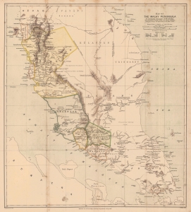
Map of the Malay Peninsula. To accompany the paper of Mr. D.D. Daly...
$1,100.00
Acquire
- Digital Map Information
- Suitable for large format printing
- File Size: 16.98 MB
- File Type: ZIP / TIFF
- ICC color profile embedded
- Delivered instantly via download link
An important map of the Malay Peninsula by Dominic Daniel Daly, lithographed by Edward Weller and published in 1882 in the Proceedings of the Royal Geographical Society. Daly's surveys of portions of the peninsula were the first scientific surveys conducted there. The map depicts the peninsula as British influence over the indigenous sultanates was expanding rapidly, aided by a boom in tin mining. (more details)
Connecting Burma and China by rail - bold but hopeless...
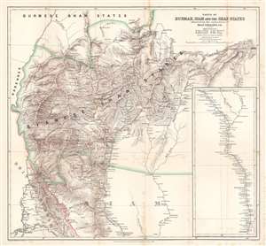
Parts of Burmah, Siam and the Shan States illustrating the explorations of Holt S. Hallett, C.E.
$400.00
Acquire
- Digital Map Information
- Suitable for large format printing
- File Size: 33.9 MB
- File Type: ZIP / TIFF
- ICC color profile embedded
- Delivered instantly via download link
This is an 1886 Henry Sharbau and H. A. Milne map of Burma (Myanmar) and Thailand. The map focuses on northern Thailand (Siam) and the railroad proposed by civil engineer Holt S. Hallett (1841 - 1911) and his associate Archibald Colquhoun (pronounced kuhl-HOON.) It was created to accompany a paper Hallett presented to the Royal Geographical Society. Red lines trace Hallett's explorations,
scouting and surveying the best railroad route. A dashed black and white line illustrated the proposed railway, running south from Kiang Hsen to the map's lower border. An inset along the right illustrates the route's continuation to Bangkok. (more details)
An early trek across southeastern Africa from Cape Town to Lake Malawi.
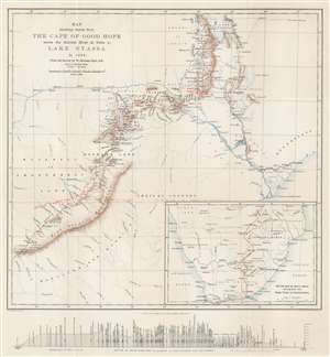
Map showing Route from the Cape of Good Hope across the Zambesi River at Tette to Lake Nyassa in 1884. From the Survey by W. Mantagu Kerr.
$350.00
Acquire
- Digital Map Information
- Suitable for large format printing
- File Size: 12.17 MB
- File Type: ZIP / TIFF
- ICC color profile embedded
- Delivered instantly via download link
This is an 1886 Henry Sharbau map of modern-day Zimbabwe, Mozambique, and Malawai tracing Walter Montagu Kerr's (1852 - 1888) exploration of the region. A thin red line follows Kerr's peregrinations, with towns and native villages labeled along the route. Major settlements including Gubuluwayo, Tette, Mpemba, Blantyre, and Quillimane near the mouths of the Zambezi River. The Zambezi is prominently illustrated, along with numerous smaller rivers. Marshes, mountain ranges, and other physical features are also noted, although very little detail is present in areas distant from Kerr's path. Red lettering marks tsetse fly territory - a serious danger to early explorers. An inset map in the lower right follows Kerr's route from Cape Town to Gubuluwayo. A profile of the 'section of route from Port Elizabeth to Lake Nyassa and Quillimane' is included below the bottom border. (more details)