1886 Sharbau Map of Zimbabwe, Mozambique, and Malawi
GoodHopeLakeNyassa-sharbau-1886$350.00
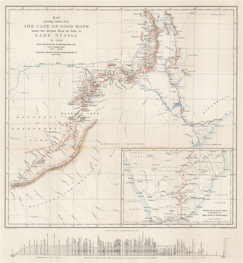

Title
Map showing Route from the Cape of Good Hope across the Zambesi River at Tette to Lake Nyassa in 1884. From the Survey by W. Mantagu Kerr.
1886 (dated) 18.5 x 17.25 in (46.99 x 43.815 cm) 1 : 2400000
1886 (dated) 18.5 x 17.25 in (46.99 x 43.815 cm) 1 : 2400000
Description
This is an 1886 Henry Sharbau map of modern-day Zimbabwe, Mozambique, and Malawai tracing Walter Montagu Kerr's (1852 - 1888) exploration of the region. A thin red line follows Kerr's peregrinations, with towns and native villages labeled along the route. Major settlements including Gubuluwayo, Tette, Mpemba, Blantyre, and Quillimane near the mouths of the Zambezi River. The Zambezi is prominently illustrated, along with numerous smaller rivers. Marshes, mountain ranges, and other physical features are also noted, although very little detail is present in areas distant from Kerr's path. Red lettering marks tsetse fly territory - a serious danger to early explorers. An inset map in the lower right follows Kerr's route from Cape Town to Gubuluwayo. A profile of the 'section of route from Port Elizabeth to Lake Nyassa and Quillimane' is included below the bottom border.
Walter Montagu Kerr (1852 - April 27, 1888)
Walter Montagu Kerr was a British explorer and world traveler. Born in Perth in 1852, Kerr attended Charterhouse School and became an engineer. He worked on the old Tay Bridge for Sir Thomas Bouch for 'some time' before leaving for California in 1873. In California he found work as the Chief Engineer at the Spring Valley Waterworks. In 1874, Kerr moved briefly to New York, before being contracted to survey mines in Mexico. After getting the mines in 'complete working order' and having made several journeys between San Francisco and Mexico for machinery, his health began to fail. This forced a visit England, but not long after he returned to New York, where he began trading on the New York Stock Exchange, where he incidentally became a popular personality. Kerr's health again declined and forced him to sell his business. This turn of events forced (or possibly allowed?) him to turn his attention to exploring Africa. He spent from autumn 1883 through sometime in 1885 traveling from Cape Town to Lake Nyassa (Lake Malawi). His health degraded once again upon his return to England from Africa, but not long after he chose to go to southern Mexico to investigate a parcel of land for a possible colonization. After returning from Mexico, Kerr wanted to mount a solo expedition to Khartoum via Cairo, but he could not get permission to enter Egypt. He decided to change his plans and entered Africa via Zanzibar, leaving England in November 1887. Unfortunately, Kerr was struck down by fever only a few days into the African interior and had to be carried out on a litter. He survived this ordeal and arrived in Cairo on a Messageries Maritimes ship in February. Cairo's climate did not help him improve, so he went to Marseilles and then Hyères, where he died on April 27th.Publication History and Census
This map was drawn by Henry Sharbau and published by Edward Stanford in the Proceedings of the Royal Geographical Society for the Royal Geographical Society in 1886. We note an example cataloged in OCLC which is part of the collection at the British Library. We also note a cataloged example as being part of the collection at the University of Illinois at Urbana Champaign.CartographerS
Henry Sharbau, (fl. 1870-1906) was a lithographer active in London and Edinburgh. While nothing is known of his early training, it is likely that his early years were spent with the navy: his earliest known works of the 1870s were on charts produced by the Hydrographic Department. The 1880s saw the beginning of a long association with the Royal Geographic Society, and then with the mapmaking firm of W. and A.K. Johnston. Over a hundred works appear in OCLC with Sharbau’s imprint. Interestingly, the British Naval Lists reveal a Frederic Henry Sharbau (1867-1963!!!) working as a cartographer and draughtsman starting about 1907 and lasting into the 20s. Perhaps this Methuselah is a son? More by this mapmaker...
Alexander Keith Johnston (December 28, 1804 - July 9, 1871) was a Scottish cartographer and map publisher active in the middle portion of the 19th century. Johnson was born at Kirkhill, near Edinburgh, Scotland. He studied at the University of Edinburgh where he apprenticed as an engraver. Around 1826, in partnership with his brother William, he founded a cartographic printing and engraving firm with the imprint "W. and A. K. Johnston." Johnston made a name for himself in educational geography, publishing numerous maps for use in schools. His brother, William Johnston, eventually left the firm to pursue a career in politics, eventually becoming the Lord Provost of Edinburgh. Alexander's son, who would bear the same name, became a geographer and explorer, suffering an untimely death on the Royal Geographical Society's 1879 expedition to Lake Nyasa. Learn More...
Royal Geographical Society (fl. 1830 - present) is a British Society established in 1830 to promote geographical science and exploration. Originally titled the "Geographical Society of London", the RGS received its royal charter from Queen Victoria in 1859 shortly after absorbing several similar but more regional societies including the African Association, the Raleigh Club and the Palestine Association. The RGS sponsored many of the most important and exciting voyages of exploration ever undertaken, including the exploration of Charles Darwin, David Livingstone, Robert Falcon Scott, Richard F. Burton, John Speke, George Hayward, H. M Stanley, Ernest Shackleton and Sir Edmond Hillary. Today, the RGS remains a leading global sponsor of geographical and scientific studies. The Society is based in Lowther Lodge, South Kensington, London. Learn More...
Source
Kerr, W. M., 'A Journey from Cape Town Overland to Lake Nyassa,' Proceedings of the Royal Geographical Society and Monthly Record of Geography Vol. 8, No. 2 (Feb. 1886) (London: Royal Geographical Society), 1886, pp. 65-87.
Condition
Very good. Exhibits light foxing and wear along original fold lines.
References
OCLC 556556337.