1886 Sharbau and Milne Map of Burma (Myanmar) and Thailand
BurmahSiamShan-sharbaumilne-1886$400.00

Title
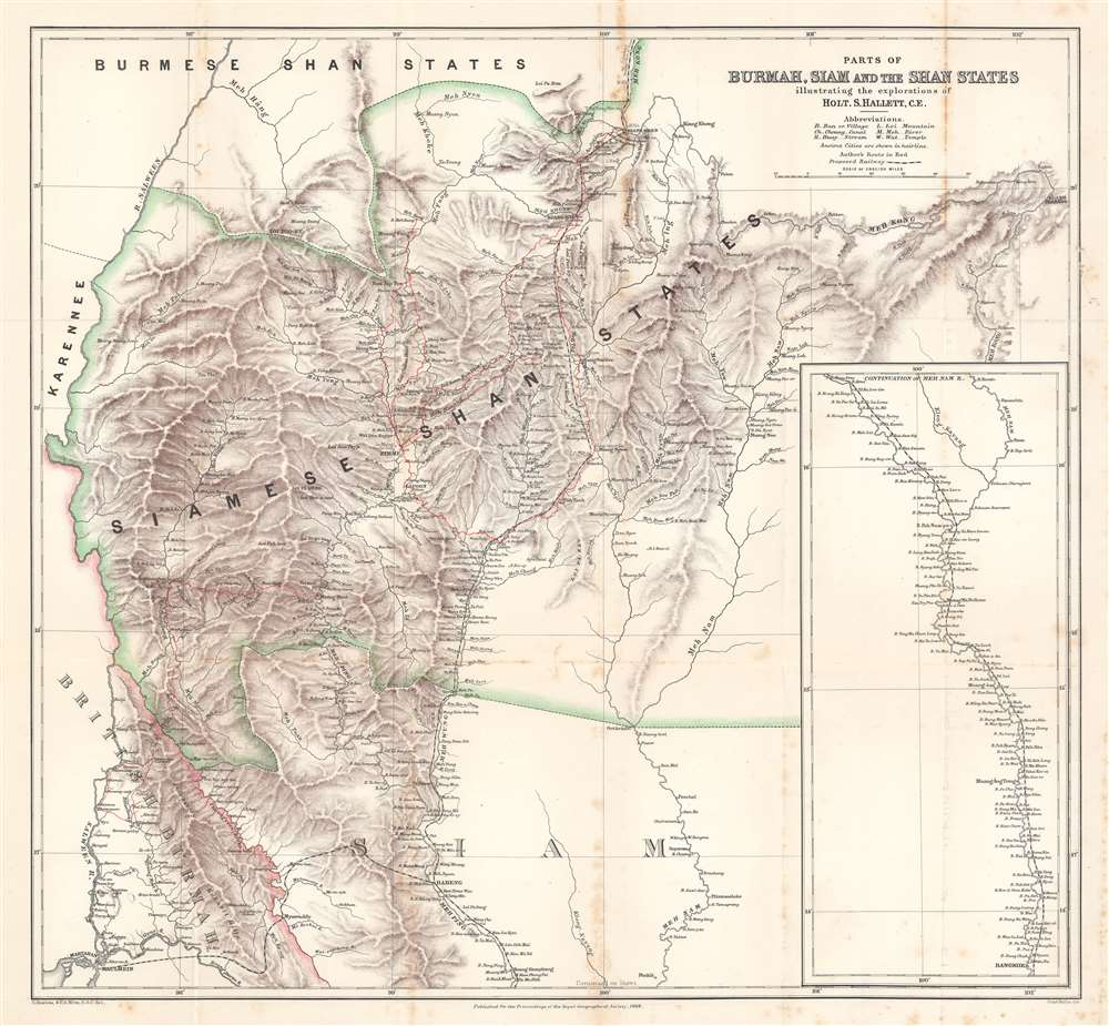
Parts of Burmah, Siam and the Shan States illustrating the explorations of Holt S. Hallett, C.E.
1886 (dated) 22.5 x 24 in (57.15 x 60.96 cm) 1 : 844800
1886 (dated) 22.5 x 24 in (57.15 x 60.96 cm) 1 : 844800
Description
This is an 1886 Henry Sharbau and H. A. Milne map of Burma (Myanmar) and Thailand. The map focuses on northern Thailand (Siam) and the railroad proposed by civil engineer Holt S. Hallett (1841 - 1911) and his associate Archibald Colquhoun (pronounced kuhl-HOON.) It was created to accompany a paper Hallett presented to the Royal Geographical Society. Red lines trace Hallett's explorations,
scouting and surveying the best railroad route. A dashed black and white line illustrated the proposed railway, running south from Kiang Hsen to the map's lower border. An inset along the right illustrates the route's continuation to Bangkok.
The Colquhoun-Hallett Scheme
The opening of Siam in 1855 led to a flood of enterprising westerners angling for concessions. By the 1880s foreign demand for investment in Siam (primarily resource extraction) reached its height. In 1885 the British annexed Northern Burma, which accelerated interest in Siam in hopes of creating a trade route between China and British Burma. In the early 1880s Colquhoun and Hallett began pressuring the Siamese to help finance survey and construction of just such a railroad. The pair continued their efforts through 1890 and canvassed Britain for investment. They spoke to Chambers of Commerce in London, Leeds, Liverpool, and Manchester (among others). In all likelihood, the paper presented to the Royal Geographical Society that included this map was part of the capital campaign. Their railway never came to fruition. An insurgency in the Shan States (northern Thailand) demanded the Siamese government's attention, as well as that of the British colonial government in Mandalay in northern Burma.The Shan States (1885 - 1948)
Occupying a large portion of this map, the Shan States were a collection of kingdoms in British Burma and northern Siam. These states had been independent kingdoms for hundreds of years. Each kingdom had its own agreement to pay tribute to a certain country for protection, either Burma or China. When the British invaded in 1885, this upset the delicate balance and led to years of fighting and insurgency. To this day, the Shan States are in open rebellion against the Myanmar central government.Publication History and Census
This map was created by Henry Sharbau and H.A. Milne to accompany a paper by Holt Samuel Hallett published in the 1886 edition of the Proceedings of the Royal Geographical Society. Three examples are cataloged in OCLC and are part of the institutional collections at Harvard University, the University of Chicago, and Southern Illinois University.CartographerS
Henry Sharbau, (fl. 1870-1906) was a lithographer active in London and Edinburgh. While nothing is known of his early training, it is likely that his early years were spent with the navy: his earliest known works of the 1870s were on charts produced by the Hydrographic Department. The 1880s saw the beginning of a long association with the Royal Geographic Society, and then with the mapmaking firm of W. and A.K. Johnston. Over a hundred works appear in OCLC with Sharbau’s imprint. Interestingly, the British Naval Lists reveal a Frederic Henry Sharbau (1867-1963!!!) working as a cartographer and draughtsman starting about 1907 and lasting into the 20s. Perhaps this Methuselah is a son? More by this mapmaker...
H. A. Milne (fl. 1879 - 1887) was a British draftsman and cartographer. Milne joined the in-house drawing office in 1879 as an assistant to William John Turner. When Turner resigned in 1881 to join W. And A. K. Johnston in Edinburgh, Milne applied for the position but was overlooked in favor of Henry Scharbau (anglicized Sharbau). Milne continued on as Sharbau's assistant until 1887 when the Royal Geographical Society let him go because of ill-health and prolonged absence. Learn More...
Edward Weller (July 1, 1819 - 1884) was a cartographer and engraver based in London. Weller was a nephew of another well-known map publisher Sidney Hall (1788 - 1831), who gave him 50 Pounds to pay his apprenticeship fees. He engraved for many prominent mapmakers and was active enough in the community to be recommended for membership to the Royal Geographical Society in 1851 on the recommendation of John Arrowsmith, among others. He eventually inherited the Sidney Hall map business which led him to follow Arrowsmith as the unofficial geographer to the Royal Geographical Society. Weller was among the first map printers in London to embrace lithography. His best known work appears in Cassell's Weekly Dispatch Atlas, published in monthly segments for subscribers of the 'Weekly Dispatch' newspaper. This collection of maps eventually grew to include much of the known world. Published in various editions from 1855 through the early 1880s. Weller died in May of 1884, leaving behind a successful business and an unhappy widow. His son, Francis Sidney Weller (1849 - 1910), followed in his father's footsteps and continued the family map business. The atlas Mackenzie's Comprehensive Gazetteer of England and Wales was published in 1894 and bore F. S. Weller's signature on the maps. Learn More...
Royal Geographical Society (fl. 1830 - present) is a British Society established in 1830 to promote geographical science and exploration. Originally titled the "Geographical Society of London", the RGS received its royal charter from Queen Victoria in 1859 shortly after absorbing several similar but more regional societies including the African Association, the Raleigh Club and the Palestine Association. The RGS sponsored many of the most important and exciting voyages of exploration ever undertaken, including the exploration of Charles Darwin, David Livingstone, Robert Falcon Scott, Richard F. Burton, John Speke, George Hayward, H. M Stanley, Ernest Shackleton and Sir Edmond Hillary. Today, the RGS remains a leading global sponsor of geographical and scientific studies. The Society is based in Lowther Lodge, South Kensington, London. Learn More...
Source
Hallett, Holt S., 'Exploration Survey for a Railway Connection between India, Siam, and China', Proceedings of the Royal Geographical Society, (London: Royal Geographical Society) 1886.
Condition
Good. Exhibits wear and foxing along original fold lines. Closed tear extending one-half (.5) inch in lower central portion of map in white section below 'Loi Pa Kau'.
References
OCLC 1139537603.