
Waugh, Frederick Coulton

Frederick Coulton Waugh (March 10, 1896 - May 23, 1973) was an American artist, painter, and writer based in Provincetown, MA and later Newburgh, New York. Waugh was born in Conwall, England. He immigrated to the United States in 1907, settling in Philadelphia with his father, maritime painter Frederick Judd Waugh (grandson of portraitist Samuel Waugh). Coulton enrolled in New York's Art Students League where he studied with George Bridgman, Frank Dumond, and John Carlson. In 1916 he took work as a textile designer before moving to Provincetown, in 1918, to open a model ship and hooked rug shop. Coulton is famous for his work in the comic strip Dickie Dare and his book The Comics, a comprehensive study analyzing comic strips and detailing their history. Coulton also taught art and wrote instructional and educational art books and edited home study course art textbooks. A professional sailor, he drew historic ships and created decorative maps. His 'serious' paintings, first displayed at the Hudson Walker Gallery in New York were, according to one writer, 'enough to give his father's admirers the jitters.' In terms of cartography, Waugh is known for producing several pictorial maps including a 'Map of Silk,' Provincetown (1924), Cape Cod (1926), Cape Ann (1927), Old Cape Cod (1930), Long Island, and the Hudson River (1958). He also issued a map of California (1940) in collaboration with his wife, Odin Burvik (aka Mabel Burwick).
Waugh's 2nd Map: Comical historical map of the Cape.
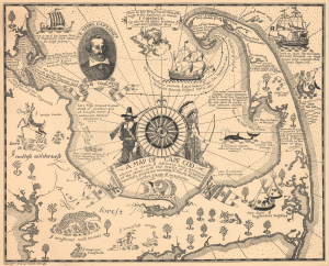
A Map of Cape Cod Wherin is showing ye discovery and ye settlement of the same; with the tracks of ye pilgrims carefully prepared according to Mourts Relation.
$950.00
Acquire
- Digital Map Information
- Suitable for large format printing
- Full resolution TIFF file
- ICC color profile embedded
- Delivered instantly via download link
This is Coulton Waugh's 1926 map of Cape Cod, the second pictorial map issued by Waugh, predated only by his map of Provincetown (1924). Riffing on early modern English cartographers, Waugh's map recounts the history of Cape Cod, in particular the Pilgrims and other early English explorers and settlers. (more details)
Includes historical notes and vignettes of sailing ships and sea monters!
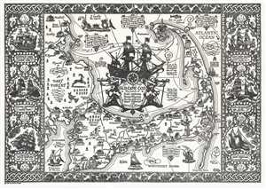
The Map of Old Cape Cod The Land of Bold explorers Heroic Pilgrims Hardy seamen Great fisheries and Famous ships.
$650.00
Acquire
- Digital Map Information
- Suitable for large format printing
- Full resolution TIFF file
- ICC color profile embedded
- Delivered instantly via download link
This is the small format edition of Frederick Coulton Waugh's 1930 pictorial map of Cape Cod, Massachusetts. It covers all of Cape Cod as well as part of the adjacent South Shore including Plymouth, Buzzard Bay, and Duxbury. The map beautifully illustrates and ... (more details)
Impressive deluxe edition of an iconic map.
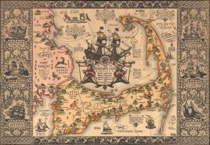
The Map of Old Cape Cod The Land of Bold explorers Heroic Pilgrims Hardy seamen Great fisheries and Famous ships.
$1,300.00
Acquire
- Digital Map Information
- Suitable for large format printing
- File Size: 25.67 MB
- File Type: ZIP / TIFF
- ICC color profile embedded
- Delivered instantly via download link
This is a beautiful example of the 1930 Frederick Coulton Waugh pictorial map of Cape Cod, Massachusetts, here in its deluxe large edition. (more details)