1930 Coulton Waugh Pictorial Map of Cape Cod, Massachusetts
CapeCod-waugh-1930-2$1,300.00

Title
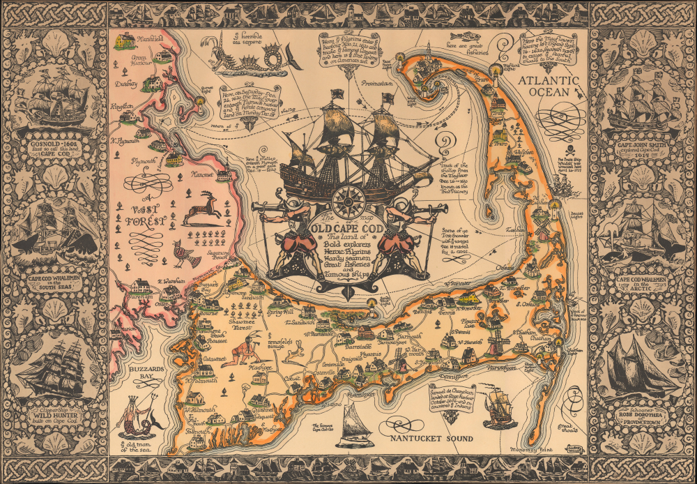
The Map of Old Cape Cod The Land of Bold explorers Heroic Pilgrims Hardy seamen Great fisheries and Famous ships.
1930 (undated) 18 x 26 in (45.72 x 66.04 cm) 1 : 156000
1930 (undated) 18 x 26 in (45.72 x 66.04 cm) 1 : 156000
Description
This is a beautiful example of the 1930 Frederick Coulton Waugh pictorial map of Cape Cod, Massachusetts, here in its deluxe large edition.
A columnist in the local weekly writes about Coulton Waugh and this particular map:
A Closer Look
Coverage embraces Cape Cod as well as part of the adjacent South Shore, including Plymouth, Buzzard Bay, and Duxbury. The map illustrates towns and roads in addition to offering rich vignettes alluding to the region's nautical heritage. These include the 'old man of the sea' in Buzzard Bay, and a 'horrible sea serpent' reported near Cape Anne, among other local folklore. Shipwrecks and historical events are also noted, including the arrival of the Mayflower. The top and bottom borders include illustrations of ships, lighthouses, and other buildings, while the left and right borders include illustrations of Cape Cod's most famous ships.A columnist in the local weekly writes about Coulton Waugh and this particular map:
Coulton Waugh was the son of noted marine painter Frederick Waugh. The two Waughs differed artistically, yet they shared a love of the sea and were on the best of terms personally. Coulton was a professional sailor and made scale drawings of historic ships, designed fabrics, and made decorative maps and charts … Coulton Waugh was considered to have revived, if not originated the art of decorative map making when he exhibited a large map of silk in 1918 at the International Silk Show in New York City. His map of Cape Cod is one of the most decorative ever prepared. The central cartouche shows the Mayflower and two Pilgrims in armor. The border was reproduced from a drawing cut with a knife in the wood-block technique. The top and bottom borders are of a stylized Cape Cod landscape and the sides borders are decorated with the images of six famous ships. The Rose Dorothea appears in the lower right-hand corner.
Publication History and Census
This map was drawn by Colton Waugh and printed in 1930. It is his second map of Cape Cod, following an earlier 1926 pictorial map. It is also the larger deluxe edition of the present map, embellished with rich original color.Cartographer
Frederick Coulton Waugh (March 10, 1896 - May 23, 1973) was an American artist, painter, and writer based in Provincetown, MA and later Newburgh, New York. Waugh was born in Conwall, England. He immigrated to the United States in 1907, settling in Philadelphia with his father, maritime painter Frederick Judd Waugh (grandson of portraitist Samuel Waugh). Coulton enrolled in New York's Art Students League where he studied with George Bridgman, Frank Dumond, and John Carlson. In 1916 he took work as a textile designer before moving to Provincetown, in 1918, to open a model ship and hooked rug shop. Coulton is famous for his work in the comic strip Dickie Dare and his book The Comics, a comprehensive study analyzing comic strips and detailing their history. Coulton also taught art and wrote instructional and educational art books and edited home study course art textbooks. A professional sailor, he drew historic ships and created decorative maps. His 'serious' paintings, first displayed at the Hudson Walker Gallery in New York were, according to one writer, 'enough to give his father's admirers the jitters.' In terms of cartography, Waugh is known for producing several pictorial maps including a 'Map of Silk,' Provincetown (1924), Cape Cod (1926), Cape Ann (1927), Old Cape Cod (1930), Long Island, and the Hudson River (1958). He also issued a map of California (1940) in collaboration with his wife, Odin Burvik (aka Mabel Burwick). More by this mapmaker...
Condition
Very good. Trimmed to neatline.
References
OCLC 41755535. Rumsey 10037.000.