
Cash, John (sold)

John Cash (17?? - 18??) was an Irish architectural draughtsman best known for his collaboration with Robert Pool on a book entitled Views of the Most Remarkable Public Buildings, Monuments, and Other Edifices in the City of Dublin. Cash entered the Dublin Society's School of Drawing in Architecture on April 1, 1773 and by 1777 had submitted the drawing for his and Pool's book to the Dublin Society. Little is known about John Cash, but a record exists of a man by that name marrying Isabella Tudor in a church in Dublin on February 19, 1783.
A detailed city map of Dublin from the late 18th century.
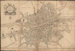
A Plan of Dublin.
sold
- Digital Map Information
- Suitable for large format printing
- DPI: 600
- File Size: 15.91 MB
- File Type: ZIP / TIFF
- ICC color profile embedded
- Delivered instantly via download link
This is a 1780 Robert Pool and John Cash city map or plan of Dublin, Ireland. The map depicts the city from the Royal Hospital to the Marine School and from Eccles Street to a bridge of 'part of the new canal'. Highly detailed, myriad streets are labeled throughout Dublin, some of which are rather small alleys. Numerous buildings are labeled, including Trinity College, the Parliament House, the castle, several hospitals, and St. Stephen's Green. The 'new canal' is illustrated in the lower left corner, with the intended extension of the canal shown by dashed lines. Wards along the city's outskirts are labeled but are left blank. Some intended streets are shown along the right border bur are left unlabeled. (more details)